METAR & TAF 7W4
Current METAR
Observed 11:15Z
K7W4 271115Z AUTO 00000KT 5SM CLR 18/18 A2988 RMK AO1 T01830183
- Wind
- 000° @ 0 kt
- Visibility
- 5 SM
- Temp / Dew
- 18°C / 18°C
- Altimeter
- 29.88 inHg
- Clouds
- CLR
- Density alt
- 845 ft
- Ceiling
- Unlimited
- Rules
- MVFR
Airport info & contacts
Manager on record, flight service, ARTCC, attendance schedule and pattern altitude — published by the FAA and refreshed every 28 days.
Location
- From city
- 0 NM NW
- VFR sectional
- WASHINGTON
- ARTCC
- ZDC · WASHINGTON
- NOTAM facility
- DCA (NOTAM-D)
Airport manager
- Name
- RICHARD HENRY REMPE
- Phone
- 804-550-5794
- Address
- 10267 MATTHEWS GROVE LN., MECHANICSVILLE VA 23116
Flight service · Hours
- FSS DCA
- LEESBURG1-800-WX-BRIEF
- Attendance
- Unattended
Frequencies
Tap any row to copy the frequency to your clipboard.
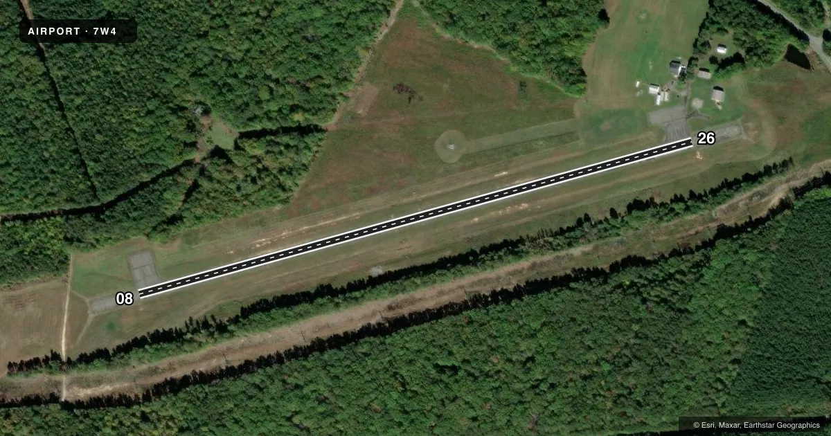
Runways & pattern
Full pagePattern entry · RWY 08
LEFT TRAFFICRunway end performance
| End | TORA | TODA | ASDA | LDA | VGSI | Approach lights | Obstruction |
|---|---|---|---|---|---|---|---|
| 08 | — | — | — | — | — | — | 63', trees, 1011' from thr, 13' R of cntrln, slope 12 |
| 26 | — | — | — | — | — | — | 59', tree, 1022' from thr, 116' R of cntrln, slope 13 |
Declared distances in feet. TORA = takeoff run available, TODA = takeoff distance, ASDA = accelerate-stop, LDA = landing distance.
Airport sketch
Runways drawn to scale from FAA survey coordinates, rendered over satellite imagery. Not for navigation.
Approaches & charts
Services on the field
Fuel grades, oxygen, maintenance, ramp storage and lighting — as declared to the FAA by the airport operator.
Fuel & services
- Fuel
- Not available
- Oxygen (bottled)
- Not available
- Oxygen (bulk)
- Not available
- Airframe repair
- Not available
- Power plant repair
- Not available
Ramp & ground
- Transient storage
- Tie-down
- Landing fee
- No fee published
- Lighting schedule
- SEE RMK
- Beacon schedule
- SS-SR
- Beacon
- White / Green (civil land)(WG)
- Wind indicator
- No
- Segmented circle
- No
Fuel & FBOs
Cheapest 100LL and Jet A on the field and nearby. Always confirm with the FBO before taxi.
Airport notes
Surface conditions, obstructions, local procedures, lighting outages and other notes published with each FAA cycle.
General notes
- DEER ON & INVOF ARPT.
- FOR CD CTC POTOMAC APCH AT 866-640-4124.
Lighting notes
- ACTVT MIRL RY 08/26 - CTAF
Other notes
- VFR ONLY
- CTAF 122.90
- MANAGEREMERGENCY PHONE NUMBER IS: (804) 514-6642
VFR map & nearby airports
VFR sectional. Tap any ICAO chip to open that airport.
Key facts · 7W4
Answer card- ICAO
- 7W4
- Name
- LAKE ANNA
- Location
- BUMPASS, VIRGINIA
- Elevation
- 351.2 ft MSL
- Traffic pattern altitude
- 1,351.2 ft MSL (1,000 AGL)
- Control tower
- Non-towered (use CTAF)
- Total runways
- 1
- Longest runway
- 08/26 · 2,558 ft
- Published ILS approaches
- 0
- Published frequencies
- 3
- Magnetic variation
- 10°
- Current flight rules
- MVFR
- Current wind
- 000° at 0 kt
- Favored runway now
- –
Lake Anna (7W4) is in Bumpass, Virginia. The field elevation is 351.2 ft MSL. It has one runway, 08/26, which is 2,558 ft long and paved. There is no control tower. No ILS approaches are published, so plan for VFR operations only. The published pattern altitude is not listed, so use the current FAA Chart Supplement before you go. The airport remarks also note deer on and near the field. Keep a sharp scan on taxi, takeoff and landing.
Runway 08/26 has medium intensity lights that are activated by using CTAF 122.90. That is useful if you expect a late arrival. Potomac Approach handles clearance delivery and approach or departure services. The published frequencies are CTAF 122.9, Potomac Approach 126.75 and Potomac Approach 307.2. There are no on-field FBOs listed. Call the airport operator or the field directly before arrival if you need fuel or other services. The airport is VFR only, so check weather and ceilings carefully before you launch. For a first-time arrival, the main things to watch are the non-towered pattern, wildlife and the short field length compared with larger paved airports.