METAR & TAF KFDK
Current METAR
Observed 12:47Z
KFDK 271247Z 00000KT 10SM CLR 24/21 A2989
- Wind
- 000° @ 0 kt
- Visibility
- 10 SM
- Temp / Dew
- 24°C / 21°C
- Altimeter
- 29.89 inHg
- Clouds
- CLR
- Density alt
- 1,500 ft
- Ceiling
- Unlimited
- Rules
- VFR
Airport info & contacts
Manager on record, flight service, ARTCC, attendance schedule and pattern altitude — published by the FAA and refreshed every 28 days.
Location
- From city
- 0 NM E
- VFR sectional
- WASHINGTON
- Pattern altitude
- 600 ft AGL · 909 ft MSL
- ARTCC
- ZDC · WASHINGTON
- NOTAM facility
- FDK (NOTAM-D)
Airport manager
- Name
- ANDREW MOORE
- Phone
- 301-600-2201
- Address
- 111 AIRPORT DRIVE EAST, FREDERICK MD 21701
Flight service · Hours
- FSS DCA
- LEESBURG1-800-WX-BRIEF
- Attendance
- 0700-2100++
Frequencies
Tap any row to copy the frequency to your clipboard.
Runways & pattern
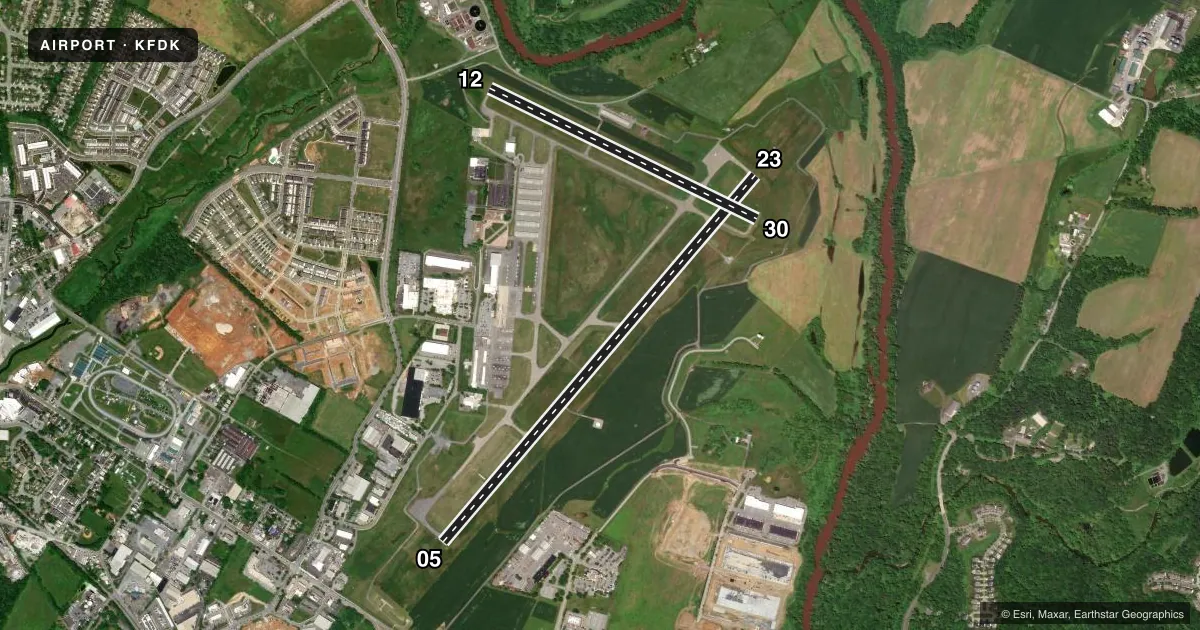
Full pagePattern entry · RWY 05
RIGHT TRAFFIC| Runway | Heading (°M) | Length | Surface | Traffic |
|---|---|---|---|---|
| 05/23 | 32° / 212° | 5,819 ft | ASPH | 05 R |
| 12/30 | 108° / 288° | 3,599 ft | ASPH | 12 R |
Runway end performance
| End | TORA | TODA | ASDA | LDA | VGSI | Approach lights | Obstruction |
|---|---|---|---|---|---|---|---|
| 05 | — | — | — | — | PAPI 4-box left(3°) | — | — |
| 23 | — | — | — | — | PAPI 4-box left(3°) | ODALS | 100', trees, 4859' from thr, 339' R of cntrln, slope 46 |
| 12 | — | — | — | — | PAPI 2-box left(3°) | — | — |
| 30 | — | — | — | — | PAPI 2-box left(4°) | — | — |
Declared distances in feet. TORA = takeoff run available, TODA = takeoff distance, ASDA = accelerate-stop, LDA = landing distance.
Airport sketch
Runways drawn to scale from FAA survey coordinates, rendered over satellite imagery. Not for navigation.
Approaches & charts
ILS · 1
Services on the field
Fuel grades, oxygen, maintenance, ramp storage and lighting — as declared to the FAA by the airport operator.
Fuel & services
- Fuel
- 100LLA
- Oxygen (bottled)
- HIGH/LOW
- Oxygen (bulk)
- Not available
- Airframe repair
- Major
- Power plant repair
- Major
- Other services
- AVNCS,CHTR,INSTR,RNTL,SALES
Ramp & ground
- Transient storage
- Tie-down
- Hangar
- Landing fee
- No fee published
- Customs
- Not available
- Lighting schedule
- SEE RMK
- Beacon schedule
- SS-SR
- Beacon
- White / Green (civil land)(WG)
- Wind indicator
- Lighted
- Segmented circle
- Yes
Fuel & FBOs
Cheapest 100LL and Jet A on the field and nearby. Always confirm with the FBO before taxi.
Airport notes
Surface conditions, obstructions, local procedures, lighting outages and other notes published with each FAA cycle.
General notes
- FOR CD WHEN TWR CLSD CTC POTOMAC APCH 126.9 OR 866-709-4993.
Lighting notes
- ACTVT ODALS RWY 23; REIL RWY 12, 23 & 30; PAPI RWY 23; HIRL RWY 05/23; MIRL RWY 12/30 - CTAF.
Fuel notes
- 100LLSELF SERVE 100LL AVBL H24 WITH CREDIT CARD.
Approach & departure obstructions
- 23-15 FT DEPRESSION 400 FT LONG; 246 FT L OF CNTRLN; PARALLEL TO APCH END.
Other notes
- EXISTED PRIOR TO 1959.
- TPA - 600 AGL HEL, 1100 AGL SNGL AND LGT TWINS, 1600 AGL LRG TWINS AND JETS.
- 1FBO UNATNDD ON CHRISTMAS DAY.
- MANAGEREMERG 301-600-1440
VFR map & nearby airports
VFR sectional. Tap any ICAO chip to open that airport.
Key facts · KFDK
Answer card- ICAO
- KFDK
- Name
- FREDERICK MUNI
- Location
- FREDERICK, MARYLAND
- Elevation
- 308.9 ft MSL
- Traffic pattern altitude
- 908.9 ft MSL (600 AGL)
- Control tower
- Towered · 0700-2100
- Total runways
- 2
- Longest runway
- 05/23 · 5,819 ft
- Published ILS approaches
- 1
- Published frequencies
- 9
- Magnetic variation
- 8°
- Current flight rules
- VFR
- Current wind
- 000° at 0 kt
- Favored runway now
- –
Frederick Muni is in Frederick, Maryland. The field elevation is 308.9 ft MSL. It has two asphalt runways. The longest is 5,819 ft on 05/23. The airport is towered from 0700 to 2100. Outside those hours, use Potomac Approach for clearance delivery on 126.9 or by phone if needed. Runway 23 has the ILS. It also has approach lighting, runway end identifier lights and a PAPI. Runways 05/23 have high intensity lights. Runways 12/30 have medium intensity lights.
Pattern altitude is 600 ft AGL for helicopters. It is 1,100 ft AGL for single-engine and light twin aircraft. Large twin-engine aircraft and jets use 1,600 ft AGL. Signature Aviation is on the field. It carries 100LL and Jet A. Self-serve 100LL is available 24 hours a day with a credit card. One runway note matters here. There is a 15-foot depression near the approach end of runway 23, left of centerline. The airport existed before 1959.
For a first-time arrival, pay attention to the tower hours and the pattern altitudes. If you are coming in after the tower closes, get your clearance and plan your frequency work ahead of time. Check the current FAA Chart Supplement for any current operational notes before you go.