METAR & TAF KGAI
Current METAR
Observed 04:56Z
KGAI 270456Z AUTO 18003KT 10SM SCT050 OVC060 24/21 A2989 RMK AO2 SLP128 T02440206
- Wind
- 180° @ 3 kt
- Visibility
- 10 SM
- Temp / Dew
- 24°C / 21°C
- Altimeter
- 29.89 inHg
- Clouds
- OVC
- Density alt
- 1,785 ft
- Ceiling
- 6,000 ft AGL
- Rules
- VFR
Airport info & contacts
Manager on record, flight service, ARTCC, attendance schedule and pattern altitude — published by the FAA and refreshed every 28 days.
Location
- From city
- 3 NM NE
- VFR sectional
- WASHINGTON
- ARTCC
- ZDC · WASHINGTON
- NOTAM facility
- DCA (NOTAM-D)
Airport manager
- Name
- JUSTIN BOLLUM, C.M.
- Phone
- 301-978-7009
- Address
- 7940 AIRPARK ROAD, SUITE 410, GAITHERSBURG MD 20879
Flight service · Hours
- FSS DCA
- LEESBURG1-800-WX-BRIEF
- Attendance
- MARCH-MAY · 0800-1900
- JUNE-SEPTEMBER · 0800-2000
- OCTOBER-FEBRUARY · 0800-1800
Frequencies
Tap any row to copy the frequency to your clipboard.
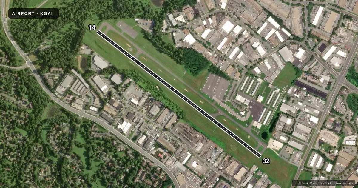
Runways & pattern
Full pagePattern entry · RWY 14
LEFT TRAFFICRunway end performance
| End | TORA | TODA | ASDA | LDA | VGSI | Approach lights | Obstruction |
|---|---|---|---|---|---|---|---|
| 14 | — | — | — | — | PAPI 4-box left(3°) | — | — |
| 32 | — | — | — | — | PAPI 4-box left(3.25°) | — | 27', trees, 952' from thr, 116' R of cntrln, slope 27 |
Declared distances in feet. TORA = takeoff run available, TODA = takeoff distance, ASDA = accelerate-stop, LDA = landing distance.
Airport sketch
Runways drawn to scale from FAA survey coordinates, rendered over satellite imagery. Not for navigation.
Approaches & charts
Services on the field
Fuel grades, oxygen, maintenance, ramp storage and lighting — as declared to the FAA by the airport operator.
Fuel & services
- Fuel
- 100LLA
- Oxygen (bottled)
- Low pressure
- Oxygen (bulk)
- Not available
- Airframe repair
- Minor
- Power plant repair
- Major
- Other services
- AFRT,AVNCS,CHTR,INSTR,RNTL,SALES
Ramp & ground
- Transient storage
- Tie-down
- Hangar
- Landing fee
- No fee published
- Customs
- Not available
- Lighting schedule
- SEE RMK
- Beacon schedule
- SS-SR
- Beacon
- White / Green (civil land)(WG)
- Wind indicator
- No
- Segmented circle
- Yes
Fuel & FBOs
Cheapest 100LL and Jet A on the field and nearby. Always confirm with the FBO before taxi.
Airport notes
Surface conditions, obstructions, local procedures, lighting outages and other notes published with each FAA cycle.
General notes
- NOISE ABATEMENT DEP RWY 32; TURN RIGHT TO AT LEAST 340 DEGS; JETS REFRAIN FROM RWY 32 TAKEOFF BTWN 2300-0700.
- DEER & BIRDS ON & INVOF ARPT.
- HELICOPTERS REFRAIN FM AIR TAXI OVER PAVED PARKING RAMPS.
- RWY 14 HAS 30 FT DOWNSLOPE 75 FT L/R OF CNTRLN AT THR TO 150 FT BOTH SIDES.
- ARPT NOT RECOMMENDED FOR ACFT WITH WINGSPAN IN EXCESS OF 79 FT & GROSS WT IN EXCESS OF 48000 POUNDS.
- SOUTH RAMP NOT RECOMMENDED FOR AIRCRAFT WITH WINGSPAN GREATER THAN 79 FT OR WEIGHT GREATER THAN 40000 LBS.
- BE ALERT SFRA PROCEDURES IN EFFECT.
- PREFERRED CALM WIND RWY 14.
- FOR CD CTC POTOMAC APCH AT 866-429-5882.
- RWY 32 PAPI BAFFLED BYD 5 DEG L OF CRS DUE TO BLDG.
Lighting notes
- ACTVT REIL RWY 14 & 32; MIRL RWY 14/32 - CTAF. PAPI RWY 14 & 32 OPR CONSLY.
Fuel notes
- 100LLFUEL TRUCK AVBL 0800-2000; REQUEST ON 122.85. SELF-SERVE 100LL AVAILABLE WITH CREDIT CARD.
Approach & departure obstructions
- 14RWY 14, 47 FT TREES, 169 FT R, 195 FT FM THR.
- 32RWY 32 HAS +15 FT RIDGE PARALLEL TO RWY 155 FT L; +6FT FENCE PARALLEL TO RWY 180 FT R.
Other notes
- THIS AIRPORT HAS BEEN SURVEYED BY THE NATIONAL GEODETIC SURVEY.
- 1000 FT AGL (1539 FT MSL) TURBINE AND JET 1500 FT AGL (2039 FT MSL) HELICOPTERS 800 FT AGL (1339 FT MSL).
- 2UNATNDD CHRISTMAS DAY. FOR AFT HRS SVC CALL 301-963-8043.
- MANAGEREXT. 1011
VFR map & nearby airports
VFR sectional. Tap any ICAO chip to open that airport.
Key facts · KGAI
Answer card- ICAO
- KGAI
- Name
- MONTGOMERY COUNTY AIRPARK
- Location
- GAITHERSBURG, MARYLAND
- Elevation
- 538.7 ft MSL
- Traffic pattern altitude
- 1,538.7 ft MSL (1,000 AGL)
- Control tower
- Non-towered (use CTAF)
- Total runways
- 1
- Longest runway
- 14/32 · 4,202 ft
- Published ILS approaches
- 0
- Published frequencies
- 5
- Magnetic variation
- 9°
- Current flight rules
- VFR
- Current wind
- 180° at 3 kt
- Favored runway now
- RWY 14
Montgomery County Airpark sits in Gaithersburg, Maryland. Field elevation is 538.7 ft MSL. The airport has one runway, 14/32, which is 4,202 ft long and paved asphalt. There is no control tower. Potomac Approach handles the area on 128.7 and 307.9. Clearance delivery is on 121.6. For IFR clearance delivery, the published contact is Potomac Approach at 866-429-5882.
No ILS approaches are published here. Pattern altitude is not published in the facts, so use the current Chart Supplement before you go. The airport is in special flight rules area procedures, so review the current procedures before arrival. Runway 32 has a noise-sensitive departure note. Jets are asked to avoid runway 32 takeoffs between 2300 and 0700. Runway 32 also has a PAPI that is baffled beyond 5 degrees left of course because of a building. Runway 14 has trees near the threshold. The airport is not recommended for aircraft with wingspan over 79 feet or gross weight over 48,000 pounds.
DC Metro Aviation Services is on the field. It carries 100LL and Jet A. Fuel truck service is available from 0800 to 2000. Self-serve 100LL is also available with credit card. Runway lights on 14 and 32 are CTAF-controlled. The runway end identifier lights and PAPI operate continuously.