METAR & TAF KHGR
Current METAR
Observed 09:53Z
KHGR 270953Z AUTO 09004KT 10SM CLR 19/17 A2986 RMK AO2 SLP116 T01940167 $
- Wind
- 090° @ 4 kt
- Visibility
- 10 SM
- Temp / Dew
- 19°C / 17°C
- Altimeter
- 29.86 inHg
- Clouds
- CLR
- Density alt
- 1,426 ft
- Ceiling
- Unlimited
- Rules
- VFR
Airport info & contacts
Manager on record, flight service, ARTCC, attendance schedule and pattern altitude — published by the FAA and refreshed every 28 days.
Location
- From city
- 4 NM N
- VFR sectional
- WASHINGTON
- ARTCC
- ZDC · WASHINGTON
- NOTAM facility
- HGR (NOTAM-D)
Airport manager
- Name
- NEIL DORAN
- Phone
- 240-313-2764
- Address
- 18434 SHOWALTER RD, HAGERSTOWN MD 21742
Flight service · Hours
- FSS DCA
- LEESBURG1-800-WX-BRIEF
- Attendance
- 0500-2200
Frequencies
Tap any row to copy the frequency to your clipboard.
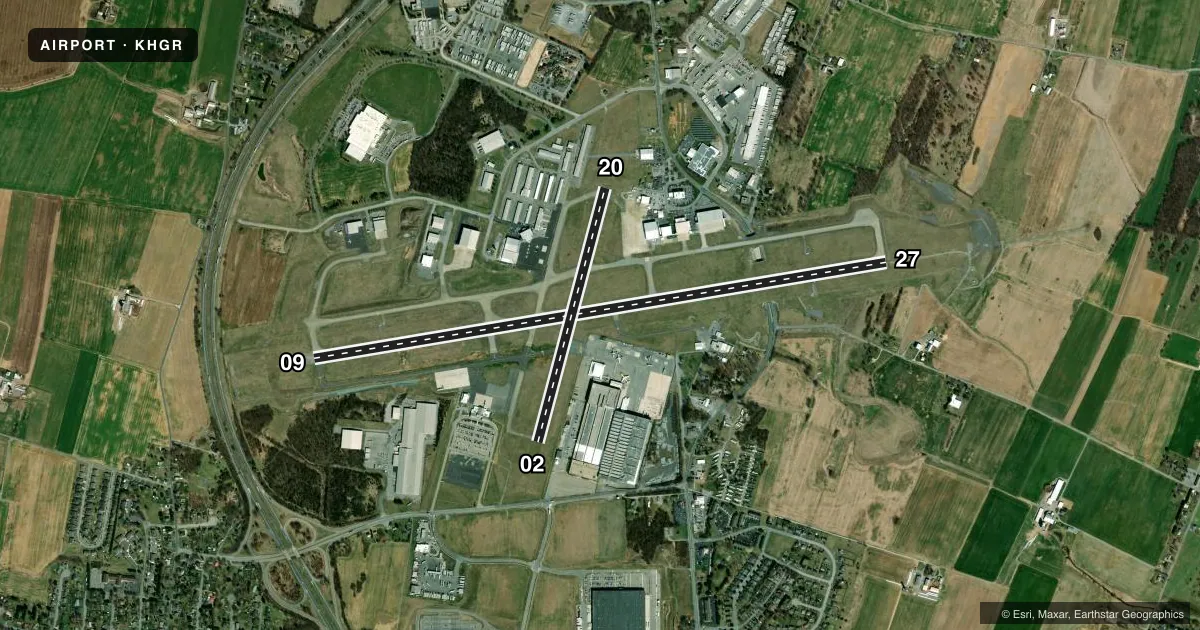
Runways & pattern
Full pagePattern entry · RWY 09
LEFT TRAFFIC| Runway | Heading (°M) | Length | Surface | Traffic |
|---|---|---|---|---|
| 09/27Favored | 70° / 250° | 7,000 ft | ASPH | Standard L |
| 02/20 | 4° / 184° | 3,165 ft | ASPH | Standard L |
Runway end performance
| End | TORA | TODA | ASDA | LDA | VGSI | Approach lights | Obstruction |
|---|---|---|---|---|---|---|---|
| 09 | 7,000' | 7,000' | 7,000' | 7,000' | PAPI 4-box left(3°) | — | — |
| 27 | 7,000' | 7,000' | 7,000' | 7,000' | PAPI 4-box left(3°) | MALSR | — |
| 02 | 3,165' | 3,165' | 3,165' | 3,165' | PAPI 2-box left(4°) | — | — |
| 20 | 3,165' | 3,165' | 3,165' | 3,165' | PAPI 2-box left(4°) | — | — |
Declared distances in feet. TORA = takeoff run available, TODA = takeoff distance, ASDA = accelerate-stop, LDA = landing distance.
Airport sketch
Runways drawn to scale from FAA survey coordinates, rendered over satellite imagery. Not for navigation.
Approaches & charts
ILS · 2
Services on the field
Fuel grades, oxygen, maintenance, ramp storage and lighting — as declared to the FAA by the airport operator.
Fuel & services
- Fuel
- 100LLA
- Oxygen (bottled)
- HIGH/LOW
- Oxygen (bulk)
- HIGH/LOW
- Airframe repair
- Major
- Power plant repair
- Major
- Other services
- AFRT,AMB,AVNCS,CARGO,CHTR,INSTR,SURV
Ramp & ground
- Transient storage
- Tie-down
- Hangar
- Landing fee
- Yes
- Customs
- Not available
- Lighting schedule
- SEE RMK
- Beacon schedule
- SS-SR
- Beacon
- White / Green (civil land)(WG)
- Wind indicator
- Lighted
- Segmented circle
- No
Fuel & FBOs
Cheapest 100LL and Jet A on the field and nearby. Always confirm with the FBO before taxi.
Airport notes
Surface conditions, obstructions, local procedures, lighting outages and other notes published with each FAA cycle.
General notes
- BIRDS ON & INVOF ARPT.
- LOW LEVEL MIL ACFT 10 NM NORTH ON VR708 OPERATING EAST TO WEST.
- ULTRALIGHT ACT 12 NM EAST TO 5000 FT MSL.
- TWY "P" NOT AVBL FOR AIR CARRIER OPS.
- RWY 02 & 20 CLSD WHEN ATCT CLSD.
- FOR CD WHEN ATCT IS CLSD CTC POTOMAC APCH AT 866-709-4993.
- PPR 24 HR PRIOR TO ACES THE MUSEUM APN. FOR MORE INFO CTC MUSEUM MGR AT 240-520-3417.
Lighting notes
- WHEN ATCT CLSD ACTVT MALSR RWY 27; REIL RWY 09; HIRL RWY 09/27 - CTAF.
Fuel notes
- 100LLFUEL AVBL 0500-2200 CALL 301-791-9119. DOD CONTRACT FUEL AVBL.
Runway surface & condition
- 02/20PCR VALUE: 600/F/A/X/T
- 09/27PCR VALUE: 750/F/A/X/T
- 02/20RWY 02/20 NOT AVBL FOR PART 121/PART 380 OPS WITH SKED PAX CARRYING OPS MORE THAN 9 PAX SEATS AND NON-SKED PAX CARRYING OPS MORE THAN 30 PAX SEATS. NO PART 121/PART 380 OPS EXC FOR TAX.
Other notes
- ARFF INDEX C AVBL UPON REQ; CTC AMGR.
- PPR 24 HRS FOR UNSKED ACR OPNS WITH MORE THAN 30 PSGR SEATS CALL AMGR 240-313-2764.
- 1AP UNATTND 2200-0500.
VFR map & nearby airports
VFR sectional. Tap any ICAO chip to open that airport.
Key facts · KHGR
Answer card- ICAO
- KHGR
- Name
- HAGERSTOWN RGNL/RICHARD A HENSON FLD
- Location
- HAGERSTOWN, MARYLAND
- Elevation
- 703.1 ft MSL
- Traffic pattern altitude
- 1,703.1 ft MSL (1,000 AGL)
- Control tower
- Towered · 0700-2200
- Total runways
- 2
- Longest runway
- 09/27 · 7,000 ft
- Published ILS approaches
- 2
- Published frequencies
- 9
- Magnetic variation
- 11°
- Current flight rules
- VFR
- Current wind
- 090° at 4 kt
- Favored runway now
- RWY 09
Hagerstown Regional Airport, also called Richard A. Henson Field, sits in Hagerstown, Maryland. Field elevation is 703.1 ft MSL. The airport has 2 asphalt runways. The longest is 09/27 at 7,000 ft. The tower is open 0700-2200. When the tower is closed, use the published lighting procedures on CTAF for runway 27, runway 09 and the 09/27 high intensity runway lights.
KHGR has 2 ILS approaches. They serve runway ends 09 and 27. Pattern altitude is not published, so verify the current Chart Supplement before you fly. For light piston traffic, plan on the standard 1,000 ft AGL unless the current published data says otherwise.
Rider Jet Center is on the field. It carries 100LL, Jet A and Jet A Prist. Fuel is available from 0500 to 2200. Call ahead if you need current ramp or service details. The airport also notes birds on and near the field. Taxiway P is not available for air carrier operations. Runway 02/20 is not available for certain large passenger operations.
This is a controlled field with Potomac Approach handling clearance delivery when the tower is closed. The airport is unattended from 2200 to 0500. If you are planning a night arrival or a first trip in, get the current Chart Supplement and brief the lighting and airspace before departure.