METAR & TAF W22
Current METAR
Observed 21:55Z
KW22 212155Z AUTO RMK AO2 PWINO
- Wind
- Calm
- Visibility
- —
- Temp / Dew
- —
- Altimeter
- —
- Clouds
- Clear
- Density alt
- —
- Ceiling
- Unlimited
- Rules
- VFR
Airport info & contacts
Manager on record, flight service, ARTCC, attendance schedule and pattern altitude — published by the FAA and refreshed every 28 days.
Location
- From city
- 2 NM W
- VFR sectional
- CINCINNATI
- ARTCC
- ZOB · CLEVELAND
- NOTAM facility
- EKN (NOTAM-D)
Airport manager
- Name
- JENNIFER L. POWERS
- Phone
- 304-472-9437
- Address
- PO BOX 1042, BUCKHANNON WV 26201
Flight service · Hours
- FSS EKN
- ELKINS703-724-42881-800-WX-BRIEF
- Attendance
- MON-FRI · 0700-1700
- SAT · 0700-1200
Frequencies
Tap any row to copy the frequency to your clipboard.
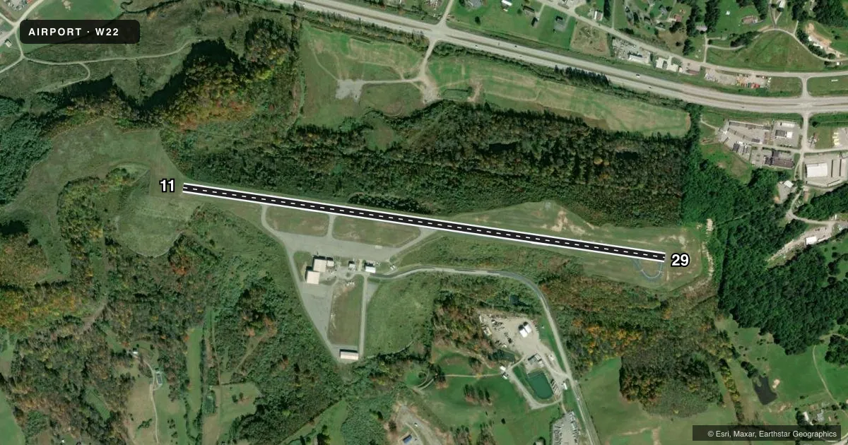
Runways & pattern
Full pagePattern entry · RWY 11
LEFT TRAFFICRunway end performance
| End | TORA | TODA | ASDA | LDA | VGSI | Approach lights | Obstruction |
|---|---|---|---|---|---|---|---|
| 11 | — | — | — | — | — | — | 42', trees, 1175' from thr, 175' R of cntrln, slope 23 |
| 29 | — | — | — | — | PAPI 2-box left(3°) | — | 20', trees, 311' from thr, 138' R of cntrln, slope 5 |
Declared distances in feet. TORA = takeoff run available, TODA = takeoff distance, ASDA = accelerate-stop, LDA = landing distance.
Airport sketch
Runways drawn to scale from FAA survey coordinates, rendered over satellite imagery. Not for navigation.
Approaches & charts
Services on the field
Fuel grades, oxygen, maintenance, ramp storage and lighting — as declared to the FAA by the airport operator.
Fuel & services
- Fuel
- 100LLA
- Oxygen (bottled)
- Not available
- Oxygen (bulk)
- Not available
- Airframe repair
- Not available
- Power plant repair
- Not available
Ramp & ground
- Transient storage
- Tie-down
- Lighting schedule
- SEE RMK
- Beacon schedule
- SS-SR
- Beacon
- White / Green (civil land)(WG)
- Wind indicator
- Lighted
- Segmented circle
- Yes
Fuel & FBOs
Cheapest 100LL and Jet A on the field and nearby. Always confirm with the FBO before taxi.
Airport notes
Surface conditions, obstructions, local procedures, lighting outages and other notes published with each FAA cycle.
General notes
- DEER ON & INVOF ARPT.
- FOR CD CTC CLARKSBURG APCH AT 304-842-2011, WHEN APCH CLSD CTC WASHINGTON CENTER AT 703-771-3479.
Lighting notes
- ACTVT PAPI RWY 29; MIRL RWY 11/29 - CTAF.
Fuel notes
- 100LL100LL 24 HR SELF SVC. FULL SVC DRG ATND HRS. AFTR HRS ON CALL.
- AJET A 24 HR SELF SVC. FULL SVC DRG ATND HRS. AFTR HRS ON CALL.
Approach & departure obstructions
- 2920 FT TREES, 311 FT DSTC, 138 FT L.
Other notes
- THIS AIRPORT HAS BEEN SURVEYED BY THE NATIONAL GEODETIC SURVEY.
- 3UNATNDD MAJ HOL, AFTR HRS ATNDT ON CALL 304-516-1920.
- MANAGERARPT PHYS ADS: 630 AIRPORT RD, BUCKHANNON, WV.
- MANAGERAFTR HRS AMGR CELL 304-516-1920 OR 304-613-7989.
- OWNERARPT AUTHORITY PRESIDENT, MIKE RUFFING.
VFR map & nearby airports
VFR sectional. Tap any ICAO chip to open that airport.
Key facts · W22
Answer card- ICAO
- W22
- Name
- UPSHUR COUNTY RGNL
- Location
- BUCKHANNON, WEST VIRGINIA
- Elevation
- 1,635.1 ft MSL
- Traffic pattern altitude
- 2,635.1 ft MSL (1,000 AGL)
- Control tower
- Non-towered (use CTAF)
- Total runways
- 1
- Longest runway
- 11/29 · 4,201 ft
- Published ILS approaches
- 0
- Published frequencies
- 4
- Magnetic variation
- 8°
- Current flight rules
- VFR
- Current wind
- Calm / unavailable
- Favored runway now
- –
Upshur County Rgnl Airport sits in Buckhannon, West Virginia. Field elevation is 1,635.1 ft MSL. The airport has one runway. Runway 11/29 is 4,201 ft long with an asphalt surface. There is no control tower. CTAF and UNICOM are both 122.8. Clearance delivery goes through Clarksburg Approach when it is open. When approach is closed, use Washington Center. No ILS approaches are published here.
Pattern altitude is not published. Use the standard 1,000 ft AGL pattern unless local procedures or the current Chart Supplement say otherwise. The field is on the higher side for a small regional airport. Plan for the usual performance check on warm days. Deer are reported on and near the airport. There are also 20 ft trees 311 ft from the threshold on the left side of runway 29. Keep that in mind on short final.
Upshur County Regional Airport is the on-field FBO. It carries 100LL, Jet A and Jet A Prist. 100LL is available 24 hours self-serve. Jet A is also available 24 hours self-serve. The runway 29 PAPI is activated. Medium intensity runway lights on 11/29 are controlled by CTAF. After hours service is available by callout. The airport is unattended on major holidays.