METAR & TAF KMPG
KMPG does not publish a METAR.
Showing the nearest reporting station: KHLG (WHEELING OHIO COUNTY) · 18.1 NM away. Conditions at KMPG may differ.
METAR · KHLG
Observed 05:53Z
KHLG 270553Z AUTO 16005KT 3SM BR CLR 19/18 A2990 RMK AO2 SLP119 T01890183 10233 20183 58010
- Wind
- 160° @ 5 kt
- Visibility
- 3 SM
- Temp / Dew
- 19°C / 18°C
- Altimeter
- 29.90 inHg
- Clouds
- CLR
- Density alt
- 2,011 ft
- Ceiling
- Unlimited
- Rules
- MVFR
Airport info & contacts
Manager on record, flight service, ARTCC, attendance schedule and pattern altitude — published by the FAA and refreshed every 28 days.
Location
- From city
- 3 NM S
- VFR sectional
- CINCINNATI
- ARTCC
- ZOB · CLEVELAND
- NOTAM facility
- EKN (NOTAM-D)
Airport manager
- Name
- SUSAN BOARD
- Phone
- 304-845-0200
- Address
- 80 AIRPORT LANE, MOUNDSVILLE WV 26041
Flight service · Hours
- FSS EKN
- ELKINS703-724-42881-800-WX-BRIEF
- Attendance
- 0830-DUSK
Frequencies
Tap any row to copy the frequency to your clipboard.
Runways & pattern
Full pagePattern entry · RWY 24
LEFT TRAFFICRunway end performance
| End | TORA | TODA | ASDA | LDA | VGSI | Approach lights | Obstruction |
|---|---|---|---|---|---|---|---|
| 06 | — | — | — | — | PAPI 2-box right(4°) | — | 213', pline, 5525' from thr, 0' R of cntrln, slope 25 |
| 24 | — | — | — | — | PAPI 2-box right(3°) | — | 128', pline, 5200' from thr, 0' R of cntrln, slope 34 |
Declared distances in feet. TORA = takeoff run available, TODA = takeoff distance, ASDA = accelerate-stop, LDA = landing distance.
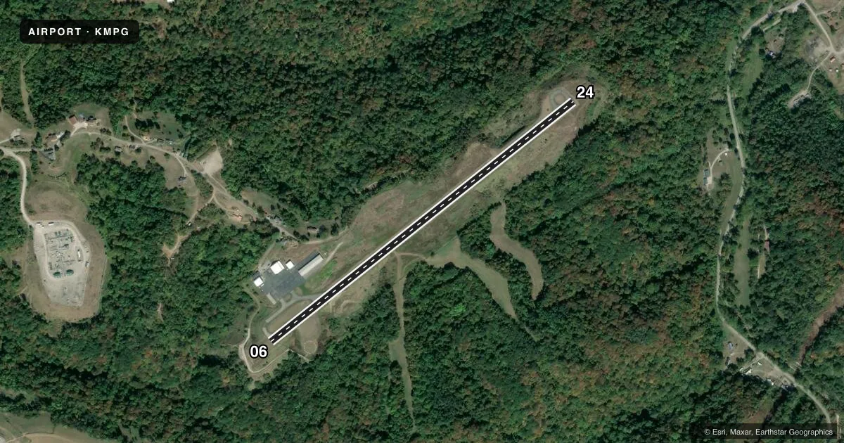
Airport sketch
Runways drawn to scale from FAA survey coordinates, rendered over satellite imagery. Not for navigation.
Approaches & charts
Services on the field
Fuel grades, oxygen, maintenance, ramp storage and lighting — as declared to the FAA by the airport operator.
Fuel & services
- Fuel
- 100LL
- Oxygen (bottled)
- Not available
- Oxygen (bulk)
- Not available
- Airframe repair
- Major
- Power plant repair
- Major
Ramp & ground
- Transient storage
- Tie-down
- Hangar
- Landing fee
- No fee published
- Customs
- Not available
- Lighting schedule
- SEE RMK
- Beacon schedule
- SEE RMK
- Beacon
- White / Green (civil land)(WG)
- Wind indicator
- Lighted
- Segmented circle
- Yes
Fuel & FBOs
Cheapest 100LL and Jet A on the field and nearby. Always confirm with the FBO before taxi.
Airport notes
Surface conditions, obstructions, local procedures, lighting outages and other notes published with each FAA cycle.
General notes
- DEER & BIRDS ON & INVOF ARPT.
- RWY 06/24 SLOPES UP 0.6% FROM SOUTH TO NORTH.
- RWY SAFETY AREA BOTH ENDS HAVE 100 FT DROP-OFFS 200 FT FM THR 0B.
- RWY 24, DUE TO TERRAIN, WINDS MAY BE TURBULENT ON APCH.
- FOR CD CTC CLEVELAND ARTCC AT 440-774-0226.
- TREES IN CLOSE VCNTY OF AWOS & WINDSOCK MAY CAUSE ERRONEOUS READINGS.
Lighting notes
- ACTVT RTG BCN - CTAF.
- ACTVT MIRL RWY 06/24 - CTAF.
Fuel notes
- 100LLSELF SERVE FUEL AVBL 24/7.
Approach & departure obstructions
- 24UNUSBL BYD 7 DEGS LEFT OF CNTRLN.
Other notes
- 1AFTER HRS ATNDT 304-312-1199 (MGR CELL).
VFR map & nearby airports
VFR sectional. Tap any ICAO chip to open that airport.
Key facts · KMPG
Answer card- ICAO
- KMPG
- Name
- MARSHALL COUNTY
- Location
- MOUNDSVILLE, WEST VIRGINIA
- Elevation
- 1,214.6 ft MSL
- Traffic pattern altitude
- 2,214.6 ft MSL (1,000 AGL)
- Control tower
- Non-towered (use CTAF)
- Total runways
- 1
- Longest runway
- 06/24 · 3,301 ft
- Published ILS approaches
- 0
- Published frequencies
- 2
- Magnetic variation
- 8°
- Current flight rules
- MVFR
- Current wind
- 160° at 5 kt
- Favored runway now
- RWY 24
Marshall County Airport sits in Moundsville, West Virginia. Field elevation is 1,214.6 ft MSL. The airport has one runway, 06/24, at 3,301 ft. There is no control tower. Expect CTAF and UNICOM use on 122.7. No ILS approaches are published here. Pattern altitude is not published. Use standard 1,000 ft AGL for light piston operations unless the current Chart Supplement says otherwise.
Marshall County Airport is a small field with some terrain and runway caution items that matter on short final. Runway 06/24 slopes up 0.6 percent from south to north. The remarks also note 100-foot drop-offs near both runway safety areas, 200 feet from threshold 0B. Runway 24 is unusable beyond 7 degrees left of centerline. Winds may be turbulent on approach to runway 24 because of terrain. Deer and birds are reported on and near the airport. Trees near the AWOS and windsock may give misleading readings.
Marshall County Airport, the on-field FBO, carries 100LL. Self-serve fuel is available 24 hours a day, 7 days a week. For after-hours help, the published manager cell is available. For clearance delivery, contact Cleveland ARTCC. If you are planning a first visit, brief the runway slope, the terrain on the 24 end and the lack of published ILS before you go.