METAR & TAF 8G6
8G6 does not publish a METAR.
Showing the nearest reporting station: KHLG (WHEELING OHIO COUNTY) · 17.2 NM away. Conditions at 8G6 may differ.
METAR · KHLG
Observed 16:53Z
KHLG 271653Z 25006KT 10SM FEW027 SCT032 27/20 A2991 RMK AO2 SLP123 T02720200
- Wind
- 250° @ 6 kt
- Visibility
- 10 SM
- Temp / Dew
- 27°C / 20°C
- Altimeter
- 29.91 inHg
- Clouds
- SCT
- Density alt
- 2,911 ft
- Ceiling
- Unlimited
- Rules
- VFR
Airport info & contacts
Manager on record, flight service, ARTCC, attendance schedule and pattern altitude — published by the FAA and refreshed every 28 days.
Location
- From city
- 2 NM S
- VFR sectional
- DETROIT
- ARTCC
- ZOB · CLEVELAND
- NOTAM facility
- CLE (NOTAM-D)
Airport manager
- Name
- MARK MILLER
- Phone
- 740-491-2815
- Address
- 43000 AIRPORT RD, CADIZ OH 43907-9605
Flight service · Hours
- FSS CLE
- CLEVELAND1-800-WX-BRIEF
- Attendance
- MON-SAT · 0900-1700
Frequencies
Tap any row to copy the frequency to your clipboard.
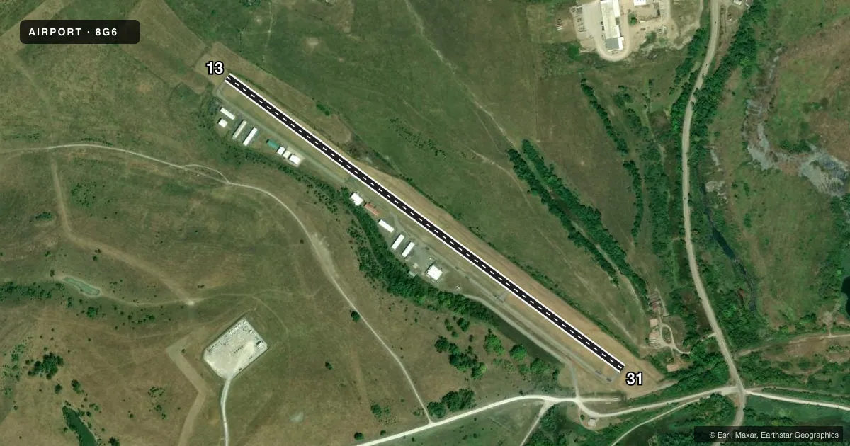
Runways & pattern
Full pagePattern entry · RWY 31
LEFT TRAFFICRunway end performance
| End | TORA | TODA | ASDA | LDA | VGSI | Approach lights | Obstruction |
|---|---|---|---|---|---|---|---|
| 13 | — | — | — | — | PAPI 2-box left(4°) | — | 40', hill, 201' from thr, 118' R of cntrln, slope 0 |
| 31 | — | — | — | — | PAPI 2-box left(4°) | — | 44', trees, 435' from thr, 238' R of cntrln, slope 5 |
Declared distances in feet. TORA = takeoff run available, TODA = takeoff distance, ASDA = accelerate-stop, LDA = landing distance.
Airport sketch
Runways drawn to scale from FAA survey coordinates, rendered over satellite imagery. Not for navigation.
Approaches & charts
Services on the field
Fuel grades, oxygen, maintenance, ramp storage and lighting — as declared to the FAA by the airport operator.
Fuel & services
- Fuel
- 100LL
- Oxygen (bottled)
- Not available
- Oxygen (bulk)
- Not available
- Airframe repair
- Not available
- Power plant repair
- Not available
Ramp & ground
- Transient storage
- Hangar
- Landing fee
- No fee published
- Customs
- Not available
- Lighting schedule
- SEE RMK
- Beacon schedule
- SS-SR
- Beacon
- White / Green (civil land)(WG)
- Wind indicator
- Lighted
- Segmented circle
- No
Fuel & FBOs
Cheapest 100LL and Jet A on the field and nearby. Always confirm with the FBO before taxi.
Airport notes
Surface conditions, obstructions, local procedures, lighting outages and other notes published with each FAA cycle.
General notes
- FOR CD CTC CLEVELAND ARTCC AT 440-774-0226/0490.
- DEER ON & INVOF ARPT.
Lighting notes
- ACTVT PAPI RWY 13 & 31; MIRL RWY 13/31 - CTAF.
Approach & departure obstructions
- 130-40 FT HILL, 0-200 FT DIST, 100 FT L TO 140 FT R.
- 316 FT MOUND, 115-200 FT DIST, 165-250 FT L.
- 13APCH SLP 0:1 TO DTHR DUE TO +40 FT HNGR, 0 FT DIST, 198 FT R.
- 31APCH SLP 0:1 TO DTHR OVR +29 FT TREE, 9 FT DIST, 179 FT R.
Other notes
- PAINT SHOP ON FLD CALL AMGR.
- DTRMN PENDING.
VFR map & nearby airports
VFR sectional. Tap any ICAO chip to open that airport.
Key facts · 8G6
Answer card- ICAO
- 8G6
- Name
- HARRISON COUNTY
- Location
- CADIZ, OHIO
- Elevation
- 1,176.2 ft MSL
- Traffic pattern altitude
- 2,176.2 ft MSL (1,000 AGL)
- Control tower
- Non-towered (use CTAF)
- Total runways
- 1
- Longest runway
- 13/31 · 4,154 ft
- Published ILS approaches
- 0
- Published frequencies
- 2
- Magnetic variation
- 8°
- Current flight rules
- VFR
- Current wind
- 250° at 6 kt
- Favored runway now
- RWY 31
Harrison County Airport sits in Cadiz, Ohio. Field elevation is 1,176.2 ft MSL. The airport has one runway, 13/31, which is 4,154 ft long and asphalt. This is an uncontrolled field. CTAF and UNICOM are both 122.8. No ILS approaches are published.
Pattern altitude is not published. Use the standard 1,000 ft AGL pattern unless the current Chart Supplement says otherwise. The on-field FBO is DESAPI Air Services. It carries AVGAS 100LL. Call (740) 942-2316 before you go if you need current service details.
A few remarks matter here. Deer are reported on and near the airport. Runway 13 has a 40-foot hangar near the approach path. Runway 31 has a 29-foot tree near the approach path. There is also a hill near runway 13 and a mound near runway 31. PAPI is available for both runways. Medium intensity runway lights are activated on CTAF. For clearance delivery, contact Cleveland ARTCC. If you are planning IFR or night work, verify the current Chart Supplement and brief the obstructions carefully before arrival.