METAR & TAF KPHD
Current METAR
Observed 16:53Z
KPHD 271653Z AUTO VRB04KT 10SM FEW035 28/20 A2990 RMK AO2 SLP118 T02830200
- Wind
- VAR @ 4 kt
- Visibility
- 10 SM
- Temp / Dew
- 28°C / 20°C
- Altimeter
- 29.90 inHg
- Clouds
- FEW
- Density alt
- 2,694 ft
- Ceiling
- Unlimited
- Rules
- VFR
Airport info & contacts
Manager on record, flight service, ARTCC, attendance schedule and pattern altitude — published by the FAA and refreshed every 28 days.
Location
- From city
- 2 NM SE
- VFR sectional
- DETROIT
- ARTCC
- ZOB · CLEVELAND
- NOTAM facility
- PHD (NOTAM-D)
Airport manager
- Name
- ERIC HUBBARD
- Phone
- 330-339-6078
- Address
- 1834 E HIGH AVE, NEW PHILADELPHIA OH 44663-3239
Flight service · Hours
- FSS CLE
- CLEVELAND1-800-WX-BRIEF
- Attendance
- MON-FRI · 0730-1700
Frequencies
Tap any row to copy the frequency to your clipboard.
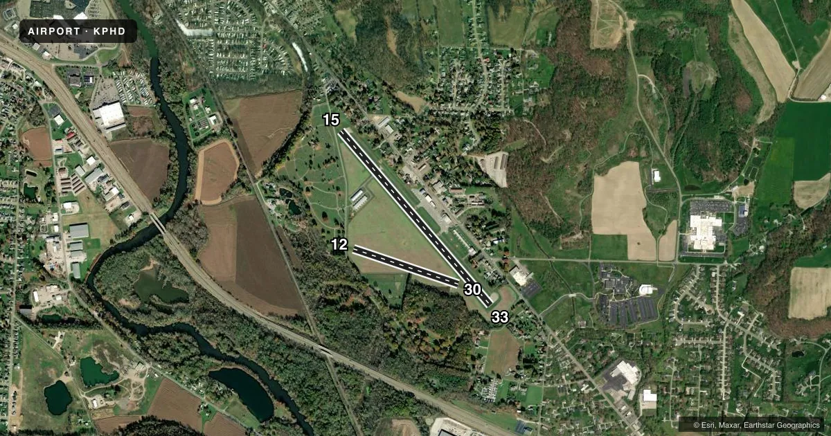
Runways & pattern
Full pagePattern entry · RWY 33
LEFT TRAFFIC| Runway | Heading (°M) | Length | Surface | Traffic |
|---|---|---|---|---|
| 15/33Favored | 131° / 311° | 3,951 ft | ASPH | Standard L |
| 12/30 | 101° / 281° | 1,907 ft | TURF | Standard L |
Runway end performance
| End | TORA | TODA | ASDA | LDA | VGSI | Approach lights | Obstruction |
|---|---|---|---|---|---|---|---|
| 15 | 3,951' | 3,951' | 3,951' | 3,621' | PAPI 4-box right(4°) | — | 15', road, 200' from thr, 9' R of cntrln, slope 0 |
| 33 | 3,951' | 3,951' | 3,634' | 3,634' | PAPI 4-box left(4°) | — | 46', trees, 401' from thr, 170' R of cntrln, slope 4 |
| 12 | 1,907' | 1,907' | 1,907' | 1,758' | — | — | 70', trees, 428' from thr, 80' R of cntrln, slope 6 |
| 30 | 1,907' | 1,907' | 1,758' | 1,758' | — | — | 81', trees, 593' from thr, 170' R of cntrln, slope 7 |
Declared distances in feet. TORA = takeoff run available, TODA = takeoff distance, ASDA = accelerate-stop, LDA = landing distance.
Airport sketch
Runways drawn to scale from FAA survey coordinates, rendered over satellite imagery. Not for navigation.
Approaches & charts
Services on the field
Fuel grades, oxygen, maintenance, ramp storage and lighting — as declared to the FAA by the airport operator.
Fuel & services
- Fuel
- 100LLA
- Oxygen (bottled)
- Not available
- Oxygen (bulk)
- Not available
- Airframe repair
- Major
- Power plant repair
- Major
- Other services
- AVNCS,INSTR,RNTL
Ramp & ground
- Transient storage
- Tie-down
- Hangar
- Landing fee
- No fee published
- Customs
- Not available
- Lighting schedule
- SEE RMK
- Beacon schedule
- SS-SR
- Beacon
- White / Green (civil land)(WG)
- Wind indicator
- Lighted
- Segmented circle
- No
Fuel & FBOs
Cheapest 100LL and Jet A on the field and nearby. Always confirm with the FBO before taxi.
Airport notes
Surface conditions, obstructions, local procedures, lighting outages and other notes published with each FAA cycle.
General notes
- TWY A CLSD WHEN ACFT ON APCH OR DEP; SFC MKG CONFLICT.
- FOR CD CTC CLEVELAND APCH AT 216-352-2323, WHEN APCH CLSD CTC CLEVELAND ARTCC AT 440-774-0223/0490.
Lighting notes
- ACTVT REIL RWY 15 & 33; MIRL RWY 15/33 - 123.3. PAPI RWY 15 & 33 OPR CONSLY.
Approach & departure obstructions
- 15+15 FT ROAD, 0-200 FT DIST, 7-115 FT R; +7 FT FENCE, 0-200 FT DIST, 15 FT L TO 90 FT R; +16 FT BLDG, 168 FT DIST, 237 FT L.
- 33+18-25 TREES, 0-100 FT DIST, 230 FT L.
- 12YELLOW CONES.
- 30YELLOW CONES.
- 33PAPI UNUSBL BYD 5 DEGS LEFT OF CNTRLN.
- 15APCH SLP 1:1 TO DTHR OVR +45 FT TREE, 45 FT DIST, 215 FT L.
Other notes
- PRIOR CDN RQRD.
- 1CLSD MAJOR HOLS; FOR SVC AFT HRS CALL AMGR CELL.
- MANAGERCELL 330-827-0820.
VFR map & nearby airports
VFR sectional. Tap any ICAO chip to open that airport.
Key facts · KPHD
Answer card- ICAO
- KPHD
- Name
- HARRY CLEVER FLD
- Location
- NEW PHILADELPHIA, OHIO
- Elevation
- 894.4 ft MSL
- Traffic pattern altitude
- 1,894.4 ft MSL (1,000 AGL)
- Control tower
- Non-towered (use CTAF)
- Total runways
- 2
- Longest runway
- 15/33 · 3,951 ft
- Published ILS approaches
- 0
- Published frequencies
- 4
- Magnetic variation
- 8°
- Current flight rules
- VFR
- Current wind
- 000° at 4 kt
- Favored runway now
- RWY 33
Harry Clever Fld sits in New Philadelphia, Ohio. Field elevation is 894.4 ft MSL. It has two runways. The longest is runway 15/33 at 3,951 ft. Runway 12/30 is turf and 1,907 ft. There is no control tower. Pattern altitude is not published, so use the standard 1,000 ft AGL for light piston traffic unless the current FAA Chart Supplement says otherwise.
No ILS approaches are published here. Expect to work the field VFR or use other published procedures if they apply to your flight. ProAv is the on-field FBO. It carries 100LL and Jet A. For current service details, call them at (330) 339-6078.
The published remarks matter here. Runway 15 and 33 have runway end identifier lights, medium intensity runway lights and PAPIs that run continuously. Taxiway A is closed when aircraft are on approach or departure. Surface markings conflict, so brief the taxi plan before you move. Runway 15 also has close-in obstacles near the threshold area. Runway 33 has trees near the departure end. The airport is closed on major holidays. For after-hours service, call the airport manager at 330-827-0820. Clearance delivery is through Cleveland Approach when available. If approach is closed, use Cleveland ARTCC per the Chart Supplement.