METAR & TAF 5D6
5D6 does not publish a METAR.
Showing the nearest reporting station: KPHD (HARRY CLEVER FLD) · 19.2 NM away. Conditions at 5D6 may differ.
METAR · KPHD
Observed 06:03Z
KPHD 270603Z AUTO 00000KT 1 3/4SM BR BKN002 18/18 A2991 RMK AO2 VIS 3/4V3 T01830183
- Wind
- 000° @ 0 kt
- Visibility
- 0.75 SM
- Temp / Dew
- 18°C / 18°C
- Altimeter
- 29.91 inHg
- Clouds
- BKN
- Density alt
- 1,947 ft
- Ceiling
- 200 ft AGL
- Rules
- LIFR
Airport info & contacts
Manager on record, flight service, ARTCC, attendance schedule and pattern altitude — published by the FAA and refreshed every 28 days.
Location
- From city
- 5 NM N
- VFR sectional
- DETROIT
- ARTCC
- ZOB · CLEVELAND
- NOTAM facility
- CLE (NOTAM-D)
Airport manager
- Name
- LEE PARSONS
- Phone
- 330-627-5794
- Address
- 5043 KENSINGTON RD NE, CARROLLTON OH 44615-9744
Flight service · Hours
- FSS CLE
- CLEVELAND1-800-WX-BRIEF
- Attendance
- IREG
Frequencies
Tap any row to copy the frequency to your clipboard.
Runways & pattern
Full pagePattern entry · RWY 10
LEFT TRAFFICRunway end performance
| End | TORA | TODA | ASDA | LDA | VGSI | Approach lights | Obstruction |
|---|---|---|---|---|---|---|---|
| 10 | — | — | — | — | — | — | 60', trees, 417' from thr, 0' R of cntrln, slope 6 |
| 28 | — | — | — | — | — | — | 65', trees, 334' from thr, 91' R of cntrln, slope 5 |
Declared distances in feet. TORA = takeoff run available, TODA = takeoff distance, ASDA = accelerate-stop, LDA = landing distance.
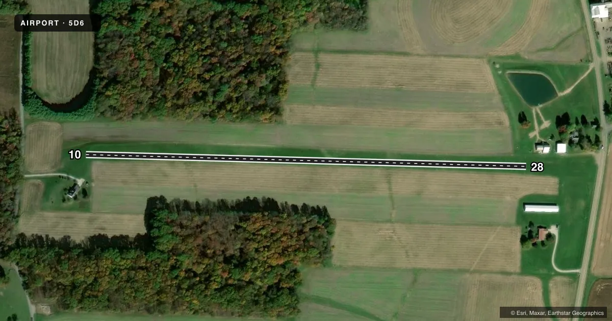
Airport sketch
Runways drawn to scale from FAA survey coordinates, rendered over satellite imagery. Not for navigation.
Approaches & charts
Services on the field
Fuel grades, oxygen, maintenance, ramp storage and lighting — as declared to the FAA by the airport operator.
Fuel & services
- Fuel
- Not available
- Oxygen (bottled)
- Not available
- Oxygen (bulk)
- Not available
- Airframe repair
- Minor
- Power plant repair
- Minor
Ramp & ground
- Transient storage
- Tie-down
- Landing fee
- No fee published
- Customs
- Not available
- Wind indicator
- Yes
- Segmented circle
- No
Fuel & FBOs
Cheapest 100LL and Jet A on the field and nearby. Always confirm with the FBO before taxi.
Airport notes
Surface conditions, obstructions, local procedures, lighting outages and other notes published with each FAA cycle.
General notes
- DEER, BIRDS, & WILDLIFE ON & INVOF ARPT.
- FOR CD CTC CLEVELAND APCH AT 216-352-2323, WHEN APCH CLSD CTC CLEVELAND ARTCC AT 440-774-0223/0490.
Runway surface & condition
- 10/28NO LINE OF SIGHT BTN RWY ENDS.
Approach & departure obstructions
- 10RWY MKD WITH WHITE PANELS FLAT TO THE GND & ORANGE & YELLOW VER SIGNS; THR MKD WITH YELLOW TIRES.
- 28RWY MKD WITH WHITE PANELS FLAT TO THE GND & ORANGE & YELLOW VER SIGNS; THR MKD WITH YELLOW TIRES.
- 28ALSO +25 FT BLDG, 126 FT DIST, 95 FT R, 5:1.
Other notes
- VFR ONLY.
- ROPES NOT PRVDD.
- 10/28UPSLP FM EAST TO WEST; SOFT WHEN WET.
VFR map & nearby airports
VFR sectional. Tap any ICAO chip to open that airport.
Key facts · 5D6
Answer card- ICAO
- 5D6
- Name
- PARSONS
- Location
- CARROLLTON, OHIO
- Elevation
- 1,270 ft MSL
- Traffic pattern altitude
- 2,270 ft MSL (1,000 AGL)
- Control tower
- Non-towered (use CTAF)
- Total runways
- 1
- Longest runway
- 10/28 · 2,570 ft
- Published ILS approaches
- 0
- Published frequencies
- 1
- Magnetic variation
- 7°
- Current flight rules
- LIFR
- Current wind
- 000° at 0 kt
- Favored runway now
- –
Parsons Airport (5D6) is in Carrollton, Ohio. The field elevation is 1,270 ft MSL. It has one runway, 10/28, which is 2,570 ft of turf and the longest runway on the field. The airport is not towered. CTAF is 122.9. No ILS approaches are published, so plan for VFR only as noted in the Chart Supplement.
Pattern altitude is not published. Use the standard 1,000 ft AGL pattern unless the current Chart Supplement or local procedures say otherwise. For this field that works out to about 2,270 ft MSL. The runway headings listed are magnetic. Runway 10 is marked with white panels flat on the ground plus orange and yellow vertical signs. Runway 28 has the same marking style. The threshold on both ends is marked with yellow tires.
There is no on-field FBO listed. Check with the airport operator or the FBO directly by phone before arrival. Published remarks also note deer, birds and other wildlife in the area. Runway 10/28 slopes upward from east to west. It is soft when wet. There is no line of sight between the runway ends. For clearance delivery, contact Cleveland Approach. If approach is closed, use Cleveland ARTCC. A 25-foot building sits near the runway end on the 28 side, so keep that in mind on departure and arrival.