METAR & TAF 38D
38D does not publish a METAR.
Showing the nearest reporting station: KYNG (YOUNGSTOWN/WARREN RGNL) · 20.5 NM away. Conditions at 38D may differ.
METAR · KYNG
Observed 12:51Z
KYNG 271251Z 24004KT 8SM FEW060 SCT140 SCT180 BKN220 21/20 A2991 RMK AO2 SLP120 T02110200 $
- Wind
- 240° @ 4 kt
- Visibility
- 8 SM
- Temp / Dew
- 21°C / 20°C
- Altimeter
- 29.91 inHg
- Clouds
- BKN
- Density alt
- 2,173 ft
- Ceiling
- 22,000 ft AGL
- Rules
- VFR
Airport info & contacts
Manager on record, flight service, ARTCC, attendance schedule and pattern altitude — published by the FAA and refreshed every 28 days.
Location
- From city
- 3 NM N
- VFR sectional
- DETROIT
- ARTCC
- ZOB · CLEVELAND
- NOTAM facility
- CLE (NOTAM-D)
Airport manager
- Name
- VICK SURACI
- Phone
- 724-316-6026
- Address
- 11718 SALEM WARREN RD, SALEM OH 44460-9667
Flight service · Hours
- FSS CLE
- CLEVELAND1-800-WX-BRIEF
- Attendance
- IREG
Frequencies
Tap any row to copy the frequency to your clipboard.
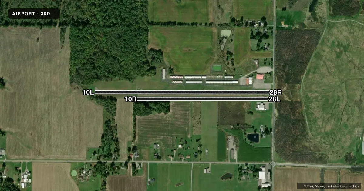
Runways & pattern
Full pagePattern entry · RWY 28R
LEFT TRAFFIC| Runway | Heading (°M) | Length | Surface | Traffic |
|---|---|---|---|---|
| 10L/28RFavored | 83° / 263° | 3,404 ft | ASPH | Standard L |
| 10R/28L | 83° / 263° | 2,550 ft | TURF | Standard L |
Runway end performance
| End | TORA | TODA | ASDA | LDA | VGSI | Approach lights | Obstruction |
|---|---|---|---|---|---|---|---|
| 10L | — | — | — | — | — | — | 40', trees, 460' from thr, 200' R of cntrln, slope 6 |
| 28R | — | — | — | — | — | — | 45', hill, 950' from thr, 200' R of cntrln, slope 16 |
| 10R | — | — | — | — | — | — | 85', trees, 0' from thr, 57' R of cntrln, slope 0 |
| 28L | — | — | — | — | — | — | 35', pole, 89' from thr, 50' R of cntrln, slope 2 |
Declared distances in feet. TORA = takeoff run available, TODA = takeoff distance, ASDA = accelerate-stop, LDA = landing distance.
Airport sketch
Runways drawn to scale from FAA survey coordinates, rendered over satellite imagery. Not for navigation.
Approaches & charts
Services on the field
Fuel grades, oxygen, maintenance, ramp storage and lighting — as declared to the FAA by the airport operator.
Fuel & services
- Fuel
- 100LL
- Oxygen (bottled)
- Not available
- Oxygen (bulk)
- Not available
- Airframe repair
- Not available
- Power plant repair
- Not available
- Other services
- INSTR
Ramp & ground
- Transient storage
- Tie-down
- Hangar
- Landing fee
- No fee published
- Customs
- Not available
- Lighting schedule
- SEE RMK
- Wind indicator
- Lighted
- Segmented circle
- No
Fuel & FBOs
Cheapest 100LL and Jet A on the field and nearby. Always confirm with the FBO before taxi.
Airport notes
Surface conditions, obstructions, local procedures, lighting outages and other notes published with each FAA cycle.
General notes
- DRAG STRIP 3500 FT SE LOOKS LIKE ARPT.
- FOR CD CTC CLEVELAND APCH AT 216-352-2323, WHEN APCH CLSD CTC CLEVELAND ARTCC AT 440-774-0223/0490.
- DEER, BIRDS, & WILDLIFE ON & INVOF ARPT.
- RWY 10R/28L: CTC AMGR FOR TURF CONDS PRIOR TO USE.
- RWY 10L/28R: ONLY 2829 FT AVBL FOR NGT OPS.
- RWY 28R: ACFT ON TURN FM DOWNWIND TO BASE MAY BE OBSC BY TREES IN APCH.
Lighting notes
- ACTVT NSTD LIRL RWY 10L/28R - CTAF.
Fuel notes
- 100LL100LL AVBL H24 SELF SVC VIA CREDIT CARD.
Runway surface & condition
- 10L/28RALL PAVEMENT RSTRD ACFT MAX GWT LESS THAN 8000 LBS.
- 10L/28RNSTD LIRL DUE TO LAYOUT & COLORS; 2829 FT LGTD.
Approach & departure obstructions
- 28RAPCH SLP 15:1 TO DTHR OVR +22 FT ROAD, 80 FT DIST, 125 FT L/R.
- 10LNSTD DUE TO THR MRKGS.
- 28RNSTD DUE TO THR MRKGS.
- 10R+80-85 FT TREES, 0-15 FT DIST, 33-57 FT R.
- 28ROBST CLNC SLOPE 7:1 TO THR OVR 96 FT TREE, 742 FT DIST, 195 FT L.
Other notes
- PRVDD PART 77 APCH SFCS RMN CLEAR OR THR DSPLCD TO PRVD 20:1 CLNC OVR OBS.
- ROPES NOT PRVDD.
- MANAGERCELL.
VFR map & nearby airports
VFR sectional. Tap any ICAO chip to open that airport.
Key facts · 38D
Answer card- ICAO
- 38D
- Name
- SALEM AIRPARK
- Location
- SALEM, OHIO
- Elevation
- 1,162 ft MSL
- Traffic pattern altitude
- 2,162 ft MSL (1,000 AGL)
- Control tower
- Non-towered (use CTAF)
- Total runways
- 2
- Longest runway
- 10L/28R · 3,404 ft
- Published ILS approaches
- 0
- Published frequencies
- 4
- Magnetic variation
- 7°
- Current flight rules
- VFR
- Current wind
- 240° at 4 kt
- Favored runway now
- RWY 28R
Salem Airpark sits in Salem, Ohio. The field elevation is 1,162 ft MSL. It has two runways. The longest is runway 10L/28R at 3,404 ft. There is no control tower. CTAF and UNICOM are both 122.7. Cleveland Approach handles IFR services on 125.5 and 371.875. No ILS approaches are published here.
The pattern altitude is not published. For a light piston aircraft, use the standard 1,000 ft AGL unless the current Chart Supplement or local procedure says otherwise. Salem Airpark has one on-field FBO, Salem Airpark. It carries 100LL. 100LL is also available 24 hours a day through self-serve credit card. The airport sits in a mixed-use area, so watch for deer, birds and other wildlife near the runway. A drag strip lies southeast of the field. It can look like airport pavement from the air.
Runway 10L/28R has nonstandard low-intensity lights that are controlled by CTAF. The pavement is restricted to aircraft under 8,000 lb maximum gross weight. Runway 10R/28L is turf. Check turf condition with the airport manager before you plan to use it. The published remarks also call out obstacle clearance issues near runway 28R. Verify current conditions before arrival, especially if you are planning a short-field or night operation.