METAR & TAF I40
Current METAR
Observed 16:15Z
KI40 271615Z AUTO 28004KT 10SM CLR 28/21 A2994 RMK AO2
- Wind
- 280° @ 4 kt
- Visibility
- 10 SM
- Temp / Dew
- 28°C / 21°C
- Altimeter
- 29.94 inHg
- Clouds
- CLR
- Density alt
- 2,749 ft
- Ceiling
- Unlimited
- Rules
- VFR
Airport info & contacts
Manager on record, flight service, ARTCC, attendance schedule and pattern altitude — published by the FAA and refreshed every 28 days.
Location
- From city
- 3 NM N
- VFR sectional
- DETROIT
- ARTCC
- ZID · INDIANAPOLIS
- NOTAM facility
- CLE (NOTAM-D)
Airport manager
- Name
- MARTY DOBSON
- Phone
- 740-622-2252
- Address
- 24569 AIRPORT RD, COSHOCTON OH 43812-9219
Flight service · Hours
- FSS CLE
- CLEVELAND1-800-WX-BRIEF
- Attendance
- 0900-1700
Frequencies
Tap any row to copy the frequency to your clipboard.
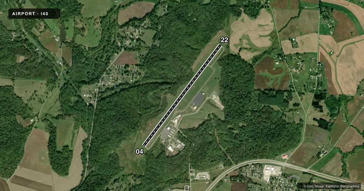
Runways & pattern
Full pagePattern entry · RWY 22
LEFT TRAFFICRunway end performance
| End | TORA | TODA | ASDA | LDA | VGSI | Approach lights | Obstruction |
|---|---|---|---|---|---|---|---|
| 04 | — | — | — | — | PAPI 2-box left(3.5°) | — | — |
| 22 | — | — | — | — | PAPI 4-box right(3°) | — | 21', trees, 378' from thr, 170' R of cntrln, slope 8 |
Declared distances in feet. TORA = takeoff run available, TODA = takeoff distance, ASDA = accelerate-stop, LDA = landing distance.
Airport sketch
Runways drawn to scale from FAA survey coordinates, rendered over satellite imagery. Not for navigation.
Approaches & charts
Services on the field
Fuel grades, oxygen, maintenance, ramp storage and lighting — as declared to the FAA by the airport operator.
Fuel & services
- Fuel
- 100LLA+
- Oxygen (bottled)
- Not available
- Oxygen (bulk)
- Not available
- Airframe repair
- Major
- Power plant repair
- Major
- Other services
- AMB,INSTR
Ramp & ground
- Transient storage
- Tie-down
- Hangar
- Landing fee
- No fee published
- Customs
- Not available
- Lighting schedule
- SEE RMK
- Beacon schedule
- SS-SR
- Beacon
- White / Green (civil land)(WG)
- Wind indicator
- Yes
- Segmented circle
- No
Fuel & FBOs
Cheapest 100LL and Jet A on the field and nearby. Always confirm with the FBO before taxi.
Airport notes
Surface conditions, obstructions, local procedures, lighting outages and other notes published with each FAA cycle.
General notes
- DEER, BIRDS, & OTR WILDLIFE ON & INVOF ARPT.
- GCO AVBL ON FREQ 121.725 INDIANAPOLIS CENTER.
- FOR CD IF UNA VIA GCO CTC INDIANAPOLIS ARTCC AT 317-247-2411.
Lighting notes
- ACTVT REIL RWY 22; MIRL RWY 04/22 - 122.9. PAPI RWY 04 & 22 OPR CONSLY.
Fuel notes
- 100LL100LL & JET A+ AVBL FULL SVC FM TRUCK.
Approach & departure obstructions
- 04+10 BRUSH, 0-150 FT DIST, 105 FT L.
- 22UNUSBL BYD 8 DEGS L OF CRS.
Other notes
- ROPES NOT PRVDD.
- 1FOR SER AFT HRS SEE SIGN IN FBO VESTIBULE FOR CTC INFO.
VFR map & nearby airports
VFR sectional. Tap any ICAO chip to open that airport.
Key facts · I40
Answer card- ICAO
- I40
- Name
- RICHARD DOWNING
- Location
- COSHOCTON, OHIO
- Elevation
- 978.9 ft MSL
- Traffic pattern altitude
- 1,978.9 ft MSL (1,000 AGL)
- Control tower
- Non-towered (use CTAF)
- Total runways
- 1
- Longest runway
- 04/22 · 5,001 ft
- Published ILS approaches
- 0
- Published frequencies
- 2
- Magnetic variation
- 7°
- Current flight rules
- VFR
- Current wind
- 280° at 4 kt
- Favored runway now
- RWY 22
Richard Downing Airport (I40) sits in Coshocton, Ohio. Field elevation is 978.9 ft MSL. The airport has one runway. Runway 04/22 is 5,001 ft long with an asphalt surface. There is no control tower. CTAF and UNICOM are both 123.0. No ILS approaches are published here.
Pattern altitude is not published in the facts, so use the standard 1,000 ft AGL for light piston traffic unless the current FAA Chart Supplement says otherwise. The field has one on-field FBO. Richard Downing Airport carries 100LL and Jet A+ with full service from truck. The published remarks also note runway lighting details. Runway 22 has REILs. Medium intensity runway lights are on 04 and 22. The PAPI on both ends operates continuously. There is also a brush obstruction near the departure end of runway 04. Wildlife is reported on and near the airport, so keep a sharp scan on taxi, takeoff and landing. For clearance delivery if needed, the published remarks point pilots to Indianapolis ARTCC. If you need after-hours help, check the sign in the FBO vestibule for contact information.