METAR & TAF KZZV
Current METAR
Observed 14:53Z
KZZV 271453Z AUTO 28004KT 10SM CLR 23/21 A2994 RMK AO2 SLP131 T02280211 50000
- Wind
- 280° @ 4 kt
- Visibility
- 10 SM
- Temp / Dew
- 23°C / 21°C
- Altimeter
- 29.94 inHg
- Clouds
- CLR
- Density alt
- 2,051 ft
- Ceiling
- Unlimited
- Rules
- VFR
Airport info & contacts
Manager on record, flight service, ARTCC, attendance schedule and pattern altitude — published by the FAA and refreshed every 28 days.
Location
- From city
- 5 NM E
- VFR sectional
- CINCINNATI
- ARTCC
- ZID · INDIANAPOLIS
- NOTAM facility
- ZZV (NOTAM-D)
Airport manager
- Name
- JIM WITTE
- Phone
- 740-452-3625
- Address
- 850 AIRPORT RD, ZANESVILLE OH 43701-0969
Flight service · Hours
- FSS CLE
- CLEVELAND1-800-WX-BRIEF
- Attendance
- MON-FRI · 0800-1800
- SAT-SUN · 1000-1800
Frequencies
Tap any row to copy the frequency to your clipboard.
Runways & pattern
Full pagePattern entry · RWY 34
LEFT TRAFFIC| Runway | Heading (°M) | Length | Surface | Traffic |
|---|---|---|---|---|
| 04/22 | 28° / 208° | 4,999 ft | ASPH | Standard L |
| 16/34Favored | 146° / 326° | 4,998 ft | ASPH | Standard L |
Runway end performance
| End | TORA | TODA | ASDA | LDA | VGSI | Approach lights | Obstruction |
|---|---|---|---|---|---|---|---|
| 04 | — | — | — | — | PAPI 4-box right(3°) | — | 55', trees, 785' from thr, 330' R of cntrln, slope 10 |
| 22 | — | — | — | — | PAPI 4-box left(3°) | — | — |
| 16 | 4,998' | 4,998' | 4,798' | 4,598' | — | — | 35', trees, 850' from thr, 115' R of cntrln, slope 18 |
| 34 | 4,998' | 4,998' | 4,798' | 4,598' | PAPI 4-box left | — | 5', brush, 215' from thr, 55' R of cntrln, slope 3 |
Declared distances in feet. TORA = takeoff run available, TODA = takeoff distance, ASDA = accelerate-stop, LDA = landing distance.
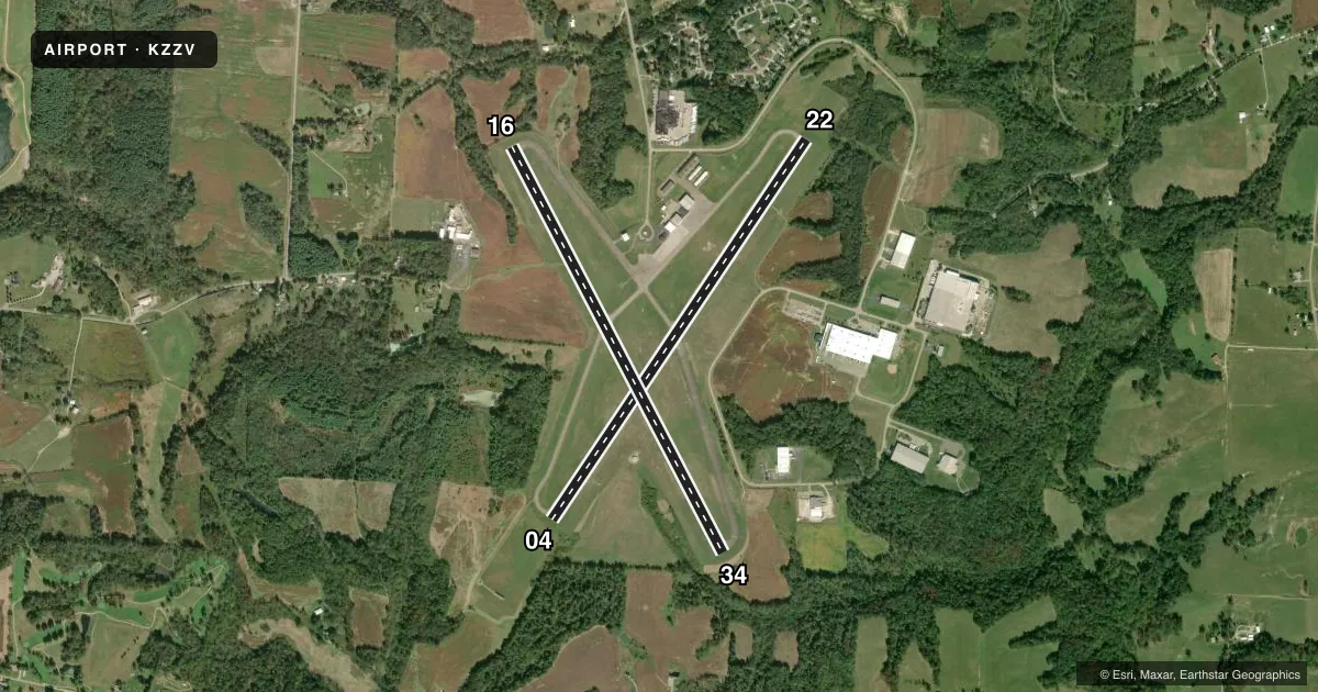
Airport sketch
Runways drawn to scale from FAA survey coordinates, rendered over satellite imagery. Not for navigation.
Approaches & charts
ILS · 1
Services on the field
Fuel grades, oxygen, maintenance, ramp storage and lighting — as declared to the FAA by the airport operator.
Fuel & services
- Fuel
- 100LLA
- Oxygen (bottled)
- Not available
- Oxygen (bulk)
- Low pressure
- Airframe repair
- Not available
- Power plant repair
- Not available
- Other services
- CHTR
Ramp & ground
- Transient storage
- Tie-down
- Hangar
- Landing fee
- No fee published
- Customs
- Not available
- Lighting schedule
- SEE RMK
- Beacon schedule
- SS-SR
- Beacon
- White / Green (civil land)(WG)
- Wind indicator
- Lighted
- Segmented circle
- No
Fuel & FBOs
Cheapest 100LL and Jet A on the field and nearby. Always confirm with the FBO before taxi.
Airport notes
Surface conditions, obstructions, local procedures, lighting outages and other notes published with each FAA cycle.
General notes
- DEER, BIRDS, & OTR WILDLIFE ON & INVOF ARPT.
- RWY 04/22 & RWY 16/34 ACFT NOT VSB FM RWY ENDS.
- TWY B LGTS U/S INDEFLY.
- FOR CD IF UNA TO CTC ON FSS FREQ, CTC INDIANAPOLIS ARTCC AT 317-247-2411.
Lighting notes
- ACTVT REIL RWY 04, 22, 16, & 34; HIRL RWY 04/22; MIRL RWY 16/34 - CTAF. PAPI RWY 04 & 22 OPR CONSLY.
Fuel notes
- AANTI-ICING AVBL AT NOZZLE.
Approach & departure obstructions
- 04RWY 04 +5 FT BRUSH 100-200 FT FM 160-275 FT R.
- 16RWY 16 +2-5 FT BRUSH 125 FT FM 130 FT L/R.
- 04FADED.
- 22FADED.
- 04PAPI UNUSBL BYD 4 DEGS RIGHT OF CNTRLN, BAFFLED DUE TO OBSTS.
- 1620:1 APCH SLP CLR TO DTHR.
- 3420:1 APCH SLP CLR TO DTHR.
Other notes
- TNST HGR: PPR.
VFR map & nearby airports
VFR sectional. Tap any ICAO chip to open that airport.
Key facts · KZZV
Answer card- ICAO
- KZZV
- Name
- ZANESVILLE MUNI
- Location
- ZANESVILLE, OHIO
- Elevation
- 899.8 ft MSL
- Traffic pattern altitude
- 1,899.8 ft MSL (1,000 AGL)
- Control tower
- Non-towered (use CTAF)
- Total runways
- 2
- Longest runway
- 04/22 · 4,999 ft
- Published ILS approaches
- 1
- Published frequencies
- 2
- Magnetic variation
- 6°
- Current flight rules
- VFR
- Current wind
- 280° at 4 kt
- Favored runway now
- RWY 34
Zanesville Muni sits in Zanesville, Ohio. Field elevation is 899.8 ft MSL. The airport has two asphalt runways. The longest is 4,999 ft. There is no control tower, so use CTAF 123.0 for traffic and UNICOM 123.0 for airport coordination.
One ILS approach is published for runway 22. Pattern altitude is not published, so plan on the standard 1,000 ft AGL for light piston operations unless the current Chart Supplement says otherwise. Zanesville Aviation is on the field. It carries AVGAS 100LL, Jet A and Jet A Prist. Anti-icing is available at the fuel nozzle.
A few remarks matter here. Runway end identifier lights are active on 04, 22, 16 and 34. High intensity runway lights are installed on 04 and 22. Medium intensity runway lights are installed on 16 and 34. The PAPI on runway 04 is limited by obstructions. Runway 04 markings are faded. Runway 22 markings are also faded. Aircraft on both runway pairs are not visible from the runway ends, so keep a sharp scan in the pattern and on taxi. Brush is reported near runways 04 and 16. The transient hangar needs prior permission before parking. For clearance delivery if FSS cannot help, contact Indianapolis ARTCC.