METAR & TAF I10
I10 does not publish a METAR.
Showing the nearest reporting station: KCDI (CAMBRIDGE MUNI) · 10.6 NM away. Conditions at I10 may differ.
METAR · KCDI
Observed 03:35Z
KCDI 270335Z AUTO 00000KT 2SM BR SCT003 18/18 A2992 RMK AO2 VIS 1 1/2V4 T01830183
- Wind
- 000° @ 0 kt
- Visibility
- 2 SM
- Temp / Dew
- 18°C / 18°C
- Altimeter
- 29.92 inHg
- Clouds
- SCT
- Density alt
- 1,450 ft
- Ceiling
- Unlimited
- Rules
- IFR
Airport info & contacts
Manager on record, flight service, ARTCC, attendance schedule and pattern altitude — published by the FAA and refreshed every 28 days.
Location
- From city
- 3 NM N
- VFR sectional
- CINCINNATI
- ARTCC
- ZOB · CLEVELAND
- NOTAM facility
- CLE (NOTAM-D)
Airport manager
- Name
- ED CROCK
- Phone
- 740-581-0557
- Address
- 301 LINCOLN DR, CALDWELL OH 43724-9807
Flight service · Hours
- FSS CLE
- CLEVELAND1-800-WX-BRIEF
- Attendance
- Unattended
Frequencies
Tap any row to copy the frequency to your clipboard.
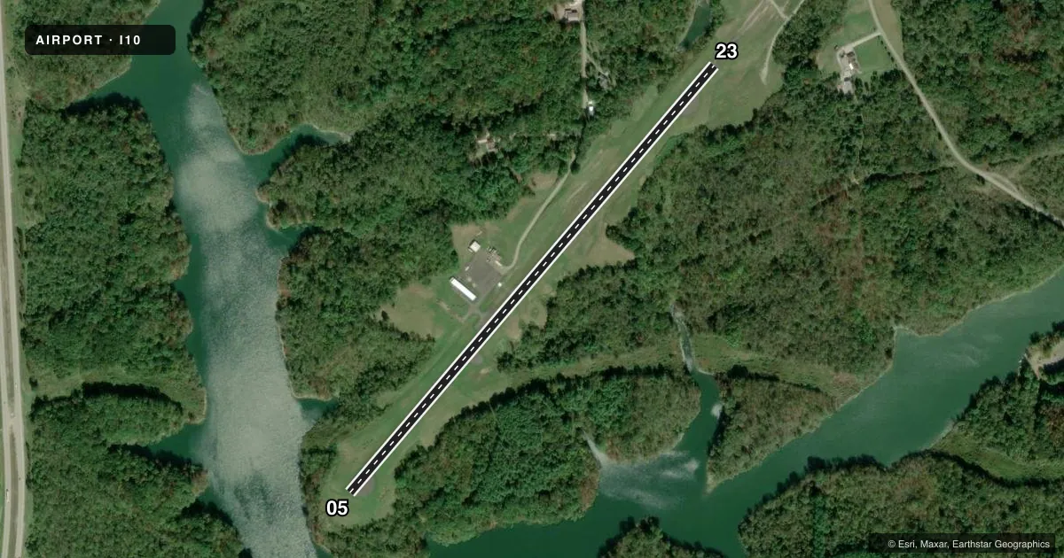
Runways & pattern
Full pagePattern entry · RWY 05
LEFT TRAFFICRunway end performance
| End | TORA | TODA | ASDA | LDA | VGSI | Approach lights | Obstruction |
|---|---|---|---|---|---|---|---|
| 05 | — | — | — | — | — | — | 12', trees, 212' from thr, 55' R of cntrln, slope 1 |
| 23 | — | — | — | — | PAPI 2-box left(3.5°) | — | 55', trees, 276' from thr, 146' R of cntrln, slope 1 |
Declared distances in feet. TORA = takeoff run available, TODA = takeoff distance, ASDA = accelerate-stop, LDA = landing distance.
Airport sketch
Runways drawn to scale from FAA survey coordinates, rendered over satellite imagery. Not for navigation.
Approaches & charts
Services on the field
Fuel grades, oxygen, maintenance, ramp storage and lighting — as declared to the FAA by the airport operator.
Fuel & services
- Fuel
- Not available
Ramp & ground
- Transient storage
- Tie-down
- Landing fee
- No fee published
- Lighting schedule
- SEE RMK
- Beacon schedule
- SEE RMK
- Beacon
- White / Green (civil land)(WG)
- Wind indicator
- Lighted
- Segmented circle
- No
Fuel & FBOs
Cheapest 100LL and Jet A on the field and nearby. Always confirm with the FBO before taxi.
Airport notes
Surface conditions, obstructions, local procedures, lighting outages and other notes published with each FAA cycle.
General notes
- DEER, BIRDS, & OTR WILDLIFE ON & INVOF ARPT.
- FOR CD CTC CLEVELAND ARTCC AT 440-774-0226/0490.
Lighting notes
- ACTVT ABN - 122.7.
- ACTVT MIRL RWY 05/23 - 122.7. PAPI RWY 23 OPR CONSLY.
Approach & departure obstructions
- 23+55 FT TREES, 0-200 FT FM THR, 125 FT R.
- 2312:1 TO DTHR.
- 23RED OBSTN LGTS MARK 56 FT HILL/TRRN, 1130 FT FM THR.
Other notes
- THIS AIRPORT HAS BEEN SURVEYED BY THE NATIONAL GEODETIC SURVEY.
- VFR ONLY.
- ROPES NOT PRVDD.
- MANAGEREDWARDCROCK@HOTMAIL.COM.
- MANAGEROR 740-581-0162; 740-517-1554.
VFR map & nearby airports
VFR sectional. Tap any ICAO chip to open that airport.
Key facts · I10
Answer card- ICAO
- I10
- Name
- NOBLE COUNTY
- Location
- CALDWELL, OHIO
- Elevation
- 879.3 ft MSL
- Traffic pattern altitude
- 1,879.3 ft MSL (1,000 AGL)
- Control tower
- Non-towered (use CTAF)
- Total runways
- 1
- Longest runway
- 05/23 · 3,811 ft
- Published ILS approaches
- 0
- Published frequencies
- 2
- Magnetic variation
- 7°
- Current flight rules
- IFR
- Current wind
- 000° at 0 kt
- Favored runway now
- –
Noble County Airport (I10) sits near Caldwell, Ohio. The field elevation is 879.3 ft MSL. It has one runway, 05/23, which is 3,811 ft long and paved with asphalt. This is a non-towered airport. The runway lights on 05/23 are medium intensity and are activated on 122.7. The airport is published as VFR only, so plan for visual conditions and keep the current Chart Supplement handy before you go.
No ILS approaches are published here. Pattern altitude is not published, so use the standard 1,000 ft AGL for light piston operations unless the current Chart Supplement says otherwise. The airport has no on-field FBOs listed in the facts provided. If you need services, contact the airport operator directly before arrival. You can also call the field on CTAF or UNICOM for current availability.
There are a few items worth briefing before arrival. Trees over 55 ft tall sit near the threshold of runway 23. A 56 ft hill or terrain feature is marked with red obstruction lights farther out on that end. The runway 23 displaced threshold also has a 12 to 1 slope. Wildlife is reported on and near the airport, so keep a sharp scan on taxi and final. Clearance delivery is handled through Cleveland ARTCC if needed.