METAR & TAF 4G5
4G5 does not publish a METAR.
Showing the nearest reporting station: KCDI (CAMBRIDGE MUNI) · 24.8 NM away. Conditions at 4G5 may differ.
METAR · KCDI
Observed 14:55Z
KCDI 271455Z AUTO 00000KT 10SM SCT018 26/22 A2994 RMK AO2 T02610224
- Wind
- 000° @ 0 kt
- Visibility
- 10 SM
- Temp / Dew
- 26°C / 22°C
- Altimeter
- 29.94 inHg
- Clouds
- SCT
- Density alt
- 2,780 ft
- Ceiling
- Unlimited
- Rules
- VFR
Airport info & contacts
Manager on record, flight service, ARTCC, attendance schedule and pattern altitude — published by the FAA and refreshed every 28 days.
Location
- From city
- 1 NM N
- VFR sectional
- CINCINNATI
- ARTCC
- ZOB · CLEVELAND
- NOTAM facility
- CLE (NOTAM-D)
Airport manager
- Name
- DAVID DALRYMPLE
- Phone
- 740-472-1882
- Address
- 47073 STATE ROUTE 26, WOODSFIELD OH 43793-9330
Flight service · Hours
- FSS CLE
- CLEVELAND1-800-WX-BRIEF
- Attendance
- IREG
Frequencies
Tap any row to copy the frequency to your clipboard.
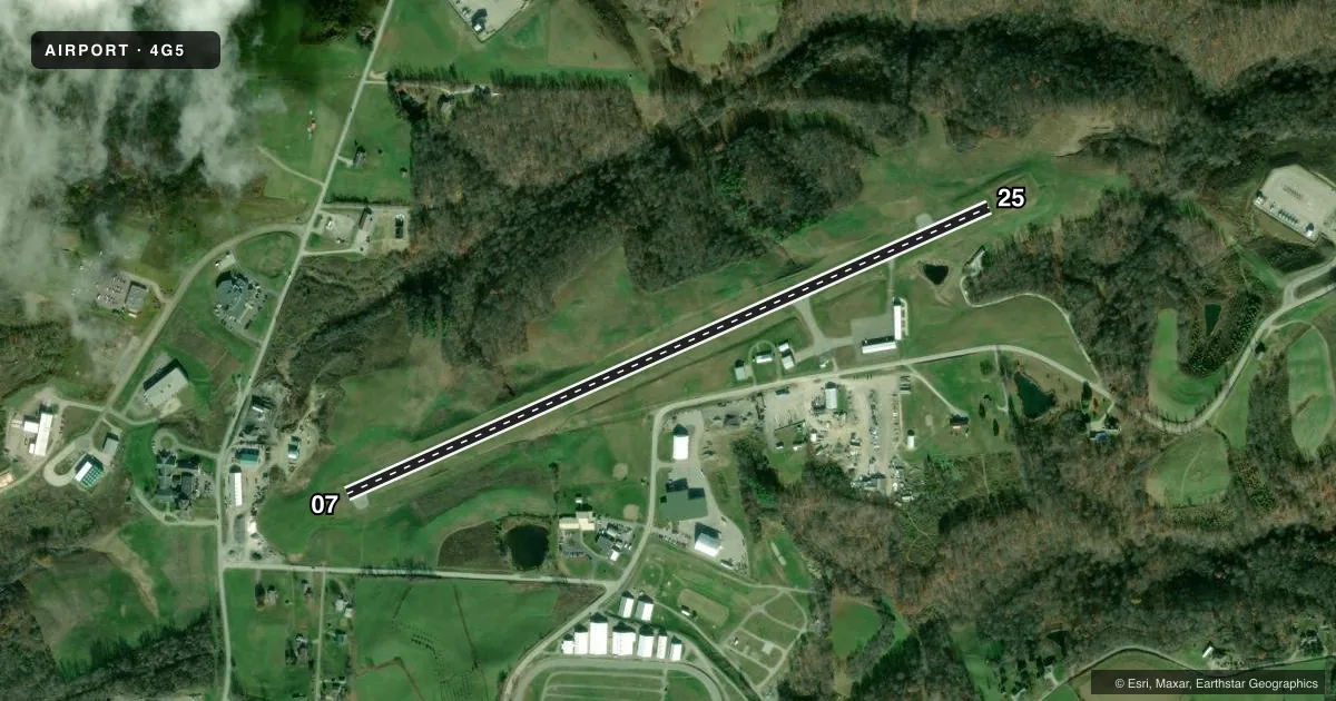
Runways & pattern
Full pagePattern entry · RWY 07
LEFT TRAFFICRunway end performance
| End | TORA | TODA | ASDA | LDA | VGSI | Approach lights | Obstruction |
|---|---|---|---|---|---|---|---|
| 25 | — | — | — | — | PAPI 2-box left(3°) | — | 39', trees, 711' from thr, 309' R of cntrln, slope 13 |
Declared distances in feet. TORA = takeoff run available, TODA = takeoff distance, ASDA = accelerate-stop, LDA = landing distance.
Airport sketch
Runways drawn to scale from FAA survey coordinates, rendered over satellite imagery. Not for navigation.
Approaches & charts
Services on the field
Fuel grades, oxygen, maintenance, ramp storage and lighting — as declared to the FAA by the airport operator.
Fuel & services
- Fuel
- 100LLA+
- Oxygen (bottled)
- Not available
- Oxygen (bulk)
- Not available
- Airframe repair
- Not available
- Power plant repair
- Not available
Ramp & ground
- Transient storage
- Tie-down
- Hangar
- Landing fee
- No fee published
- Customs
- Not available
- Lighting schedule
- SEE RMK
- Beacon schedule
- SS-SR
- Beacon
- White / Green (civil land)(WG)
- Wind indicator
- Lighted
- Segmented circle
- No
Fuel & FBOs
Cheapest 100LL and Jet A on the field and nearby. Always confirm with the FBO before taxi.
Airport notes
Surface conditions, obstructions, local procedures, lighting outages and other notes published with each FAA cycle.
General notes
- OCNL DEER, BIRDS, & OTR WILDLIFE ON & INVOF ARPT.
- FOR CD CTC CLEVELAND ARTCC AT 440-774-0226.
Lighting notes
- ACTVT REIL RWY 25; MIRL RWY 07/25 - CTAF. PAPI RWY 25 OPR CONSLY.
Fuel notes
- 100LLFULL SER ONLY CALL AMGR CELL.
Approach & departure obstructions
- 07FADED.
- 25FADED.
Other notes
- MANAGERCELL 740-213-3106.
VFR map & nearby airports
VFR sectional. Tap any ICAO chip to open that airport.
Key facts · 4G5
Answer card- ICAO
- 4G5
- Name
- MONROE COUNTY
- Location
- WOODSFIELD, OHIO
- Elevation
- 1,197.1 ft MSL
- Traffic pattern altitude
- 2,197.1 ft MSL (1,000 AGL)
- Control tower
- Non-towered (use CTAF)
- Total runways
- 1
- Longest runway
- 07/25 · 3,805 ft
- Published ILS approaches
- 0
- Published frequencies
- 2
- Magnetic variation
- 8°
- Current flight rules
- VFR
- Current wind
- 000° at 0 kt
- Favored runway now
- –
Monroe County Airport sits near Woodsfield, Ohio. Field elevation is 1,197.1 ft MSL. The airport has one runway. Runway 07/25 is 3,805 ft long with an asphalt surface. This is an uncontrolled field. CTAF and UNICOM are both 122.8.
No ILS approaches are published here. Pattern altitude is not published, so a light piston pilot should plan on the standard 1,000 ft AGL unless the current Chart Supplement says otherwise. The published remarks matter here. Runway 25 has REILs. Medium intensity runway lights are on runways 07 and 25. They are controlled by CTAF. The PAPI on runway 25 operates continuously. Both runway 07 and runway 25 have faded markings. Expect a little extra visual scan on rollout and in the pattern.
Monroe County Airport has one on-field FBO listed as Monroe County Airport. It carries 100LL, Jet A and Jet A Prist. Full service 100LL is available only by calling the airport manager first. The manager cell number is 740-213-3106. For clearance delivery, contact Cleveland ARTCC at 440-774-0226. Watch for deer, birds and other wildlife on or near the airport. At this elevation, performance planning still matters. Especially on warm days.