METAR & TAF I86
I86 does not publish a METAR.
Showing the nearest reporting station: KZZV (ZANESVILLE MUNI) · 20.7 NM away. Conditions at I86 may differ.
METAR · KZZV
Observed 15:53Z
KZZV 271553Z AUTO 30007KT 10SM FEW021 SCT030 27/22 A2993 RMK AO2 SLP129 T02670217
- Wind
- 300° @ 7 kt
- Visibility
- 10 SM
- Temp / Dew
- 27°C / 22°C
- Altimeter
- 29.93 inHg
- Clouds
- SCT
- Density alt
- 2,732 ft
- Ceiling
- Unlimited
- Rules
- VFR
Airport info & contacts
Manager on record, flight service, ARTCC, attendance schedule and pattern altitude — published by the FAA and refreshed every 28 days.
Location
- From city
- 2 NM S
- VFR sectional
- CINCINNATI
- ARTCC
- ZID · INDIANAPOLIS
- NOTAM facility
- CLE (NOTAM-D)
Airport manager
- Name
- LAWRENCE NASH
- Phone
- 740-605-1932
- Address
- 1870 AIRPORT RD, NEW LEXINGTON OH 43764-9681
Flight service · Hours
- FSS CLE
- CLEVELAND1-800-WX-BRIEF
- Attendance
- Unattended
Frequencies
Tap any row to copy the frequency to your clipboard.
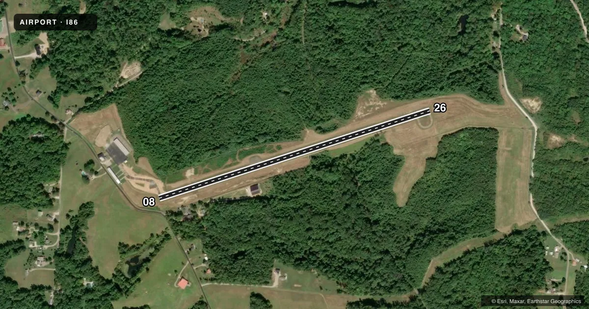
Runways & pattern
Full pagePattern entry · RWY 26
LEFT TRAFFICRunway end performance
| End | TORA | TODA | ASDA | LDA | VGSI | Approach lights | Obstruction |
|---|---|---|---|---|---|---|---|
| 08 | — | — | — | — | PAPI 2-box right(3.5°) | — | 9', fence, 287' from thr, 19' R of cntrln, slope 9 |
| 26 | — | — | — | — | PAPI 2-box left(4°) | — | 44', trees, 322' from thr, 250' R of cntrln, slope 2 |
Declared distances in feet. TORA = takeoff run available, TODA = takeoff distance, ASDA = accelerate-stop, LDA = landing distance.
Airport sketch
Runways drawn to scale from FAA survey coordinates, rendered over satellite imagery. Not for navigation.
Approaches & charts
Services on the field
Fuel grades, oxygen, maintenance, ramp storage and lighting — as declared to the FAA by the airport operator.
Fuel & services
- Fuel
- Not available
- Oxygen (bottled)
- Not available
- Oxygen (bulk)
- Not available
- Airframe repair
- Not available
- Power plant repair
- Not available
Ramp & ground
- Transient storage
- Hangar
- Landing fee
- No fee published
- Customs
- Not available
- Lighting schedule
- SEE RMK
- Beacon schedule
- SS-SR
- Beacon
- White / Green (civil land)(WG)
- Wind indicator
- Lighted
- Segmented circle
- No
Fuel & FBOs
Cheapest 100LL and Jet A on the field and nearby. Always confirm with the FBO before taxi.
Airport notes
Surface conditions, obstructions, local procedures, lighting outages and other notes published with each FAA cycle.
General notes
- DEER & TURKEYS ON & INVOF ARPT.
- FOR CD CTC COLUMBUS APCH AT 614-338-8537.
Lighting notes
- ACTVT REIL RWY 26; MIRL RWY 08/26 - CTAF.
Approach & departure obstructions
- 08+2-10 FT BRUSH, 0-125 FT DIST, 85 FT R.
- 26+8 FT FENCE, 0-124 FT DIST, 120-140 FT R.
Other notes
- PRIOR CDN RQRD FOR HNGR.
VFR map & nearby airports
VFR sectional. Tap any ICAO chip to open that airport.
Key facts · I86
Answer card- ICAO
- I86
- Name
- ED NEWLON FLD
- Location
- NEW LEXINGTON, OHIO
- Elevation
- 1,051.7 ft MSL
- Traffic pattern altitude
- 2,051.7 ft MSL (1,000 AGL)
- Control tower
- Non-towered (use CTAF)
- Total runways
- 1
- Longest runway
- 08/26 · 3,498 ft
- Published ILS approaches
- 0
- Published frequencies
- 2
- Magnetic variation
- 7°
- Current flight rules
- VFR
- Current wind
- 300° at 7 kt
- Favored runway now
- RWY 26
ED Newlon Fld sits in New Lexington, Ohio. The field elevation is 1,051.7 ft MSL. It has one runway, 08/26, which is 3,498 ft long and paved with asphalt. There is no control tower. CTAF and UNICOM are both 122.8.
No ILS approaches are published here. The pattern altitude is not published, so use the standard 1,000 ft AGL for light piston operations unless the current Chart Supplement says otherwise. Runway 08 has brush near the departure end. Runway 26 has an 8-foot fence near the departure end on the right side. Deer and turkeys are reported on and near the airport. Keep a sharp scan on taxi, takeoff and landing.
Runway 26 has activated runway end identifier lights. Medium intensity runway lights are on both 08 and 26. They are controlled by the common traffic advisory frequency. Prior coordination is required for hangar use. For clearance delivery, contact Columbus Approach at 614-338-8537. There is no on-field FBO listed. Verify current services with the airport operator or call the field directly before you go.