METAR & TAF 22I
22I does not publish a METAR.
Showing the nearest reporting station: KUNI (OHIO UNIVERSITY) · 12.1 NM away. Conditions at 22I may differ.
METAR · KUNI
Observed 13:15Z
KUNI 271315Z AUTO 00000KT 9SM FEW003 21/21 A2996 RMK AO2 T02100210
- Wind
- 000° @ 0 kt
- Visibility
- 9 SM
- Temp / Dew
- 21°C / 21°C
- Altimeter
- 29.96 inHg
- Clouds
- FEW
- Density alt
- 1,854 ft
- Ceiling
- Unlimited
- Rules
- VFR
Airport info & contacts
Manager on record, flight service, ARTCC, attendance schedule and pattern altitude — published by the FAA and refreshed every 28 days.
Location
- From city
- 5 NM NNE
- VFR sectional
- CINCINNATI
- ARTCC
- ZID · INDIANAPOLIS
- NOTAM facility
- DAY (NOTAM-D)
Airport manager
- Name
- NICK RUPERT
- Phone
- 740-357-0268
- Address
- 66285 AIRPORT RD, NEW PLYMOUTH OH 45654-8927
Flight service · Hours
- FSS DAY
- DAYTON1-800-WX-BRIEF
- Attendance
- IREG
Frequencies
Tap any row to copy the frequency to your clipboard.
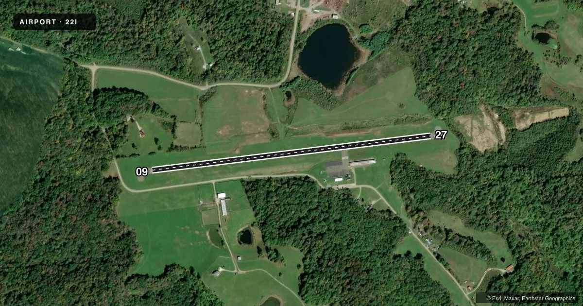
Runways & pattern
Full pagePattern entry · RWY 09
LEFT TRAFFICRunway end performance
| End | TORA | TODA | ASDA | LDA | VGSI | Approach lights | Obstruction |
|---|---|---|---|---|---|---|---|
| 09 | — | — | — | — | — | — | 43', trees, 359' from thr, 92' R of cntrln, slope 3 |
| 27 | — | — | — | — | PAPI 2-box left(4°) | — | 20', brush, 296' from thr, 115' R of cntrln, slope 4 |
Declared distances in feet. TORA = takeoff run available, TODA = takeoff distance, ASDA = accelerate-stop, LDA = landing distance.
Airport sketch
Runways drawn to scale from FAA survey coordinates, rendered over satellite imagery. Not for navigation.
Approaches & charts
Services on the field
Fuel grades, oxygen, maintenance, ramp storage and lighting — as declared to the FAA by the airport operator.
Fuel & services
- Fuel
- 100LL
- Oxygen (bottled)
- Not available
- Oxygen (bulk)
- Not available
- Airframe repair
- Not available
- Power plant repair
- Not available
- Other services
- CHTR,INSTR,RNTL
Ramp & ground
- Transient storage
- Tie-down
- Landing fee
- No fee published
- Lighting schedule
- SEE RMK
- Beacon schedule
- SS-SR
- Beacon
- White / Green (civil land)(WG)
- Wind indicator
- Lighted
- Segmented circle
- No
Fuel & FBOs
Cheapest 100LL and Jet A on the field and nearby. Always confirm with the FBO before taxi.
Airport notes
Surface conditions, obstructions, local procedures, lighting outages and other notes published with each FAA cycle.
General notes
- OCNL DEER & GEESE ON & INVOF ARPT.
- FOR CD CTC INDIANAPOLIS ARTCC AT 317-247-2411.
Lighting notes
- ACTVT PAPI RWY 27; LIRL RWY 09/27 - 122.9.
Fuel notes
- 100LLFOR FUEL CALL AMGR.
Approach & departure obstructions
- 27TREES & BRUSH, 50-200 FT DIST, 80 FT L TO 125 FT R.
Other notes
- VFR USE ONLY.
- 09/27WDSPR, OPN, & UNSEALED CRACKS.
VFR map & nearby airports
VFR sectional. Tap any ICAO chip to open that airport.
Key facts · 22I
Answer card- ICAO
- 22I
- Name
- VINTON COUNTY
- Location
- MC ARTHUR, OHIO
- Elevation
- 954.2 ft MSL
- Traffic pattern altitude
- 1,954.2 ft MSL (1,000 AGL)
- Control tower
- Non-towered (use CTAF)
- Total runways
- 1
- Longest runway
- 09/27 · 3,500 ft
- Published ILS approaches
- 0
- Published frequencies
- 2
- Magnetic variation
- 5°
- Current flight rules
- VFR
- Current wind
- 000° at 0 kt
- Favored runway now
- –
Vinton County Airport sits in Mc Arthur, Ohio. Field elevation is 954.2 ft MSL. The airport has one runway. Runway 09/27 is 3,500 ft long with an asphalt surface. There is no control tower. CTAF and UNICOM are both 122.8. No ILS approaches are published, so plan this field as a VFR stop only.
Pattern altitude is not published. Use the standard 1,000 ft AGL pattern unless local guidance says otherwise. The on-field FBO is Vinton County Airport. It carries 100LL. For fuel, call the airport manager at (740) 596-2588. Published remarks note that the PAPI is active for runway 27. Low intensity runway lights are available for 09 and 27 on 122.9. The runway surface is weathered and has unsealed cracks. Trees and brush sit close to runway 27, so keep that in mind on the approach and rollout.
This is a VFR-only airport. Expect wildlife too. Deer and geese are reported on and near the field. If you need clearance delivery, contact Indianapolis ARTCC at 317-247-2411. For a first visit, brief the runway condition, the lighting setup and the obstacle picture near 27 before you go.