METAR & TAF 3I2
3I2 does not publish a METAR.
Showing the nearest reporting station: KUNI (OHIO UNIVERSITY) · 18.9 NM away. Conditions at 3I2 may differ.
METAR · KUNI
Observed 17:55Z
KUNI 261755Z AUTO 25004KT 10SM FEW270 27/20 A2995 RMK AO2 60000 T02680205 10268 20209 58015
- Wind
- 250° @ 4 kt
- Visibility
- 10 SM
- Temp / Dew
- 27°C / 20°C
- Altimeter
- 29.95 inHg
- Clouds
- FEW
- Density alt
- 2,201 ft
- Ceiling
- Unlimited
- Rules
- VFR
Airport info & contacts
Manager on record, flight service, ARTCC, attendance schedule and pattern altitude — published by the FAA and refreshed every 28 days.
Location
- From city
- 4 NM NE
- VFR sectional
- CINCINNATI
- ARTCC
- ZID · INDIANAPOLIS
- NOTAM facility
- EKN (NOTAM-D)
Airport manager
- Name
- TRENT AND PAIGE ROUSH
- Phone
- 304-674-5075
- Address
- 1518 AIRPORT RD, POINT PLEASANT WV 25550
Flight service · Hours
- FSS EKN
- ELKINS703-724-42881-800-WX-BRIEF
- Attendance
- MON-FRI · 1000-1400
Frequencies
Tap any row to copy the frequency to your clipboard.
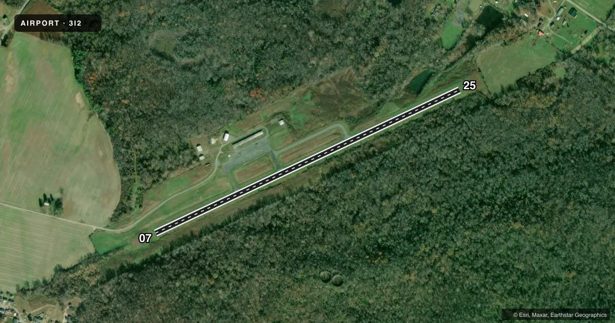
Runways & pattern
Full pagePattern entry · RWY 25
LEFT TRAFFICRunway end performance
| End | TORA | TODA | ASDA | LDA | VGSI | Approach lights | Obstruction |
|---|---|---|---|---|---|---|---|
| 07 | — | — | — | — | PAPI 2-box left(3°) | — | 20', trees, 420' from thr, 20' R of cntrln, slope 11 |
| 25 | — | — | — | — | PAPI 2-box left(3°) | — | 35', trees, 300' from thr, 140' R of cntrln, slope 2 |
Declared distances in feet. TORA = takeoff run available, TODA = takeoff distance, ASDA = accelerate-stop, LDA = landing distance.
Airport sketch
Runways drawn to scale from FAA survey coordinates, rendered over satellite imagery. Not for navigation.
Approaches & charts
Services on the field
Fuel grades, oxygen, maintenance, ramp storage and lighting — as declared to the FAA by the airport operator.
Fuel & services
- Fuel
- Not available
- Oxygen (bottled)
- Not available
- Oxygen (bulk)
- Not available
Ramp & ground
- Transient storage
- Not published
- Landing fee
- No fee published
- Customs
- Not available
- Lighting schedule
- SEE RMK
- Beacon schedule
- SS-SR
- Beacon
- White / Green (civil land)(WG)
- Wind indicator
- Lighted
- Segmented circle
- Yes
Fuel & FBOs
Cheapest 100LL and Jet A on the field and nearby. Always confirm with the FBO before taxi.
Airport notes
Surface conditions, obstructions, local procedures, lighting outages and other notes published with each FAA cycle.
General notes
- DEER ON & INVOF ARPT.
- STEAM FROM COOLING TOWERS NW OCCASIONALLY OBSCURES OBSTN LGTS ON TOWER NORTH.
- RWY 07 HAS 3 FT DITCH 80 FT L & R OF CNTRLN FIRST 1000 FT.
- 6-8 FT BRUSH PARALLEL TO RWY 25, 95 FT FM CENTERLINE.
- COLD TEMPERATURE AIRPORT. ALTITUDE CORRECTION REQUIRED AT OR BELOW -16C.
- FOR CD CTC HUNTINGTON ATCT AT 304-453-2490.
- SEVERAL POWER PLANT STACKS IN VICINITY OF ARPT WEST & NORTH.
- RWY 25, 35 FT DROP-OFF, 100 FT FM RWY END.
Lighting notes
- ACTVT REIL RWY 07 & 25; PAPI RWY 07 & 25; MIRL RWY 07/25 - CTAF.
Approach & departure obstructions
- 0730 FT TREES, 0-199 DSTC, 75 FT R.
- 07RWY 25 35 FT DROPOFF 100 FT FM THLD 0B.
- 07CTLG OBSTN EXCEEDS A 45 DEG SLP.
Other notes
- NO OBJECTION.
VFR map & nearby airports
VFR sectional. Tap any ICAO chip to open that airport.
Key facts · 3I2
Answer card- ICAO
- 3I2
- Name
- MASON COUNTY
- Location
- POINT PLEASANT, WEST VIRGINIA
- Elevation
- 643.4 ft MSL
- Traffic pattern altitude
- 1,643.4 ft MSL (1,000 AGL)
- Control tower
- Non-towered (use CTAF)
- Total runways
- 1
- Longest runway
- 07/25 · 4,000 ft
- Published ILS approaches
- 0
- Published frequencies
- 4
- Magnetic variation
- 7°
- Current flight rules
- VFR
- Current wind
- 250° at 4 kt
- Favored runway now
- RWY 25
Mason County Airport sits in Point Pleasant, West Virginia. Field elevation is 643.4 ft MSL. The airport has one runway. Runway 07/25 is 4,000 ft long with an asphalt surface. There is no control tower. CTAF and UNICOM are both 122.8. Approach and departure service is handled by Huntington on 128.4 and 270.1.
No ILS approaches are published here. Pattern altitude is not published in the supplied facts, so use the current Chart Supplement before you go. Raven Aviation is on the field. Fuel grades were not reported in the facts, so call them at (304) 675-7765 for current availability.
This field has several items that matter on short final and in the rollout. Runway 07 has a ditch area left and right of centerline for the first 1,000 ft. Runway 25 has a dropoff near the departure end. There are also trees, brush near runway 25, power plant stacks west and north of the airport and deer in the area. Runway lights, REILs and PAPI are published for both ends. Clearance delivery is handled through Huntington Air Traffic Control Tower at 304-453-2490. Check the current Chart Supplement for any published noise or curfew restrictions before flying into the field.