METAR & TAF I18
I18 does not publish a METAR.
Showing the nearest reporting station: KUNI (OHIO UNIVERSITY) · 25.5 NM away. Conditions at I18 may differ.
METAR · KUNI
Observed 06:35Z
KUNI 270635Z AUTO 00000KT 1SM BR VV001 19/19 A2991 RMK AO2 T01890189
- Wind
- 000° @ 0 kt
- Visibility
- 1 SM
- Temp / Dew
- 19°C / 19°C
- Altimeter
- 29.91 inHg
- Clouds
- VV
- Density alt
- 1,433 ft
- Ceiling
- 100 ft AGL
- Rules
- LIFR
Airport info & contacts
Manager on record, flight service, ARTCC, attendance schedule and pattern altitude — published by the FAA and refreshed every 28 days.
Location
- From city
- 6 NM SW
- VFR sectional
- CINCINNATI
- ARTCC
- ZID · INDIANAPOLIS
- NOTAM facility
- EKN (NOTAM-D)
Airport manager
- Name
- SAM DENNIS
- Phone
- 304-273-8114
- Address
- 912 AIRPORT RD, MILLWOOD WV 25262
Flight service · Hours
- FSS EKN
- ELKINS703-724-42881-800-WX-BRIEF
- Attendance
- 0800-1600
Frequencies
Tap any row to copy the frequency to your clipboard.
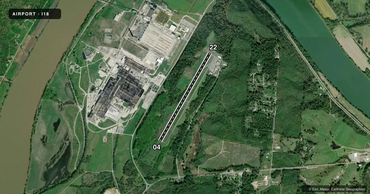
Runways & pattern
Full pagePattern entry · RWY 04
LEFT TRAFFICRunway end performance
| End | TORA | TODA | ASDA | LDA | VGSI | Approach lights | Obstruction |
|---|---|---|---|---|---|---|---|
| 04 | — | — | — | — | PAPI 2-box left(3°) | — | 35', trees, 201' from thr, 204' R of cntrln, slope 0 |
| 22 | — | — | — | — | PAPI 2-box left(4°) | — | 30', trees, 201' from thr, 246' R of cntrln, slope 0 |
Declared distances in feet. TORA = takeoff run available, TODA = takeoff distance, ASDA = accelerate-stop, LDA = landing distance.
Airport sketch
Runways drawn to scale from FAA survey coordinates, rendered over satellite imagery. Not for navigation.
Approaches & charts
Services on the field
Fuel grades, oxygen, maintenance, ramp storage and lighting — as declared to the FAA by the airport operator.
Fuel & services
- Fuel
- 100LLAA+
- Oxygen (bottled)
- Not available
- Oxygen (bulk)
- Not available
- Airframe repair
- Major
- Power plant repair
- Major
- Other services
- AMB,INSTR,RNTL
Ramp & ground
- Transient storage
- Tie-down
- Hangar
- Landing fee
- No fee published
- Lighting schedule
- SEE RMK
- Beacon schedule
- SS-SR
- Beacon
- White / Green (civil land)(WG)
- Wind indicator
- Lighted
- Segmented circle
- Yes
Fuel & FBOs
Cheapest 100LL and Jet A on the field and nearby. Always confirm with the FBO before taxi.
Airport notes
Surface conditions, obstructions, local procedures, lighting outages and other notes published with each FAA cycle.
General notes
- DEER AND BIRDS ON & INVOF ARPT.
- 1229 MSL STACK 1/2 MILE NW OF ARPT.
- RWY SAFETY AREA SFC UNEVEN.
- RWY 04, 50 FT DROP-OFF 200 FT FM THR.
- 15 FT TREES PARALLEL TO RWY 04, 75 FT L OF CNTRLN.
- FOR CD CTC HUNTINGTON ATCT AT 304-453-2490.
Lighting notes
- ACTVT REIL RWY 04 & 22, PAPI RWY 04 & 22; MIRL RWY 04/22 & WINDSOCK LGT - CTAF.
Approach & departure obstructions
- 2230 FT TREES, 150-199 DSTC, 247 FT L.
- 04CTLNG OBSTN EXCEEDS A 45 DEG SLP.
- 22CTLNG OBSTN EXCEEDS A 45 DEG SLP.
Other notes
- 1EXC THANKSGIVING & CHRISTMAS.
- MANAGER304-761-6212 MGR CELL.
VFR map & nearby airports
VFR sectional. Tap any ICAO chip to open that airport.
Key facts · I18
Answer card- ICAO
- I18
- Name
- JACKSON COUNTY
- Location
- RAVENSWOOD, WEST VIRGINIA
- Elevation
- 758.2 ft MSL
- Traffic pattern altitude
- 1,758.2 ft MSL (1,000 AGL)
- Control tower
- Non-towered (use CTAF)
- Total runways
- 1
- Longest runway
- 04/22 · 4,000 ft
- Published ILS approaches
- 0
- Published frequencies
- 4
- Magnetic variation
- 7°
- Current flight rules
- LIFR
- Current wind
- 000° at 0 kt
- Favored runway now
- –
Jackson County Airport is in Ravenswood, West Virginia. The field elevation is 758.2 ft MSL. It has one runway, 04/22, at 4,000 ft asphalt. There is no control tower. The published traffic pattern altitude is not listed, so use the standard 1,000 ft AGL for light piston operations unless current local guidance says otherwise.
No ILS approaches are published here. The airport uses CTAF 122.8 and UNICOM 122.8. Approach and departure service is handled by Huntington on 128.4 and 270.1. Jackson County Airport is the on-field FBO. It carries 100LL, Jet A and Jet A Prist. Call (304) 273-8114 before arrival if you need current ramp or fuel handling details.
There are a few items a first-time pilot should brief. Runway 04 has a 50 foot drop-off 200 feet from the threshold. Trees sit near runway 04 on the left side. Runway 22 has obstacle notes too. These include trees near the approach path and a controlling obstacle that exceeds a 45 degree slope. Deer and birds are reported on and near the airport. The runway safety area surface is uneven. The airport is attended daily except on Thanksgiving and Christmas. For clearance delivery, contact Huntington ATCT at 304-453-2490.