METAR & TAF KCRW
Current METAR
Observed 13:15Z
KCRW 271315Z 00000KT 1/4SM FG VV002 21/21 A2995 RMK AO2 PWR OK T02110211 $
- Wind
- 000° @ 0 kt
- Visibility
- 0.25 SM
- Temp / Dew
- 21°C / 21°C
- Altimeter
- 29.95 inHg
- Clouds
- VV
- Density alt
- 1,857 ft
- Ceiling
- 200 ft AGL
- Rules
- LIFR
Airport info & contacts
Manager on record, flight service, ARTCC, attendance schedule and pattern altitude — published by the FAA and refreshed every 28 days.
Location
- From city
- 3 NM E
- VFR sectional
- CINCINNATI
- ARTCC
- ZID · INDIANAPOLIS
- NOTAM facility
- CRW (NOTAM-D)
Airport manager
- Name
- MS DOMINIQUE RANIERI, ESQ., C.M.
- Phone
- 304-344-8033
- Address
- 100 AIRPORT ROAD SUITE 175, CHARLESTON WV 25311
Flight service · Hours
- FSS EKN
- ELKINS703-724-42881-800-WX-BRIEF
- Attendance
- ALL
Frequencies
Tap any row to copy the frequency to your clipboard.
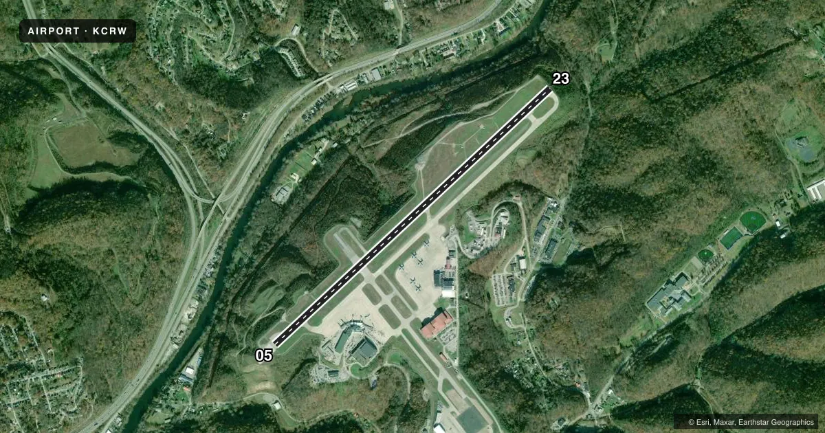
Runways & pattern
Full pagePattern entry · RWY 05
LEFT TRAFFICRunway end performance
| End | TORA | TODA | ASDA | LDA | VGSI | Approach lights | Obstruction |
|---|---|---|---|---|---|---|---|
| 05 | 6,715' | 6,715' | 6,215' | 6,215' | PAPI 4-box left(3°) | — | 223', pole, 3950' from thr, 950' R of cntrln, slope 16 |
| 23 | 6,715' | 6,715' | 6,715' | 6,215' | VASI 4-box right(3°) | ALSF1 | 136', pole, 4300' from thr, 100' R of cntrln, slope 30 |
Declared distances in feet. TORA = takeoff run available, TODA = takeoff distance, ASDA = accelerate-stop, LDA = landing distance.
Airport sketch
Runways drawn to scale from FAA survey coordinates, rendered over satellite imagery. Not for navigation.
Approaches & charts
ILS · 2
Services on the field
Fuel grades, oxygen, maintenance, ramp storage and lighting — as declared to the FAA by the airport operator.
Fuel & services
- Fuel
- 100LLA
- Oxygen (bottled)
- Not available
- Oxygen (bulk)
- Not available
- Airframe repair
- Major
- Power plant repair
- Major
- Other services
- AMB,CARGO,CHTR,INSTR,RNTL,SALES
Ramp & ground
- Transient storage
- Tie-down
- Hangar
- Landing fee
- Yes
- Customs
- Not available
- Beacon schedule
- SS-SR
- Beacon
- White / Green (civil land)(WG)
- Wind indicator
- Lighted
- Segmented circle
- No
Fuel & FBOs
Cheapest 100LL and Jet A on the field and nearby. Always confirm with the FBO before taxi.
Airport notes
Surface conditions, obstructions, local procedures, lighting outages and other notes published with each FAA cycle.
General notes
- DEER & BIRDS ON & INVOF ARPT.
- MILITARY: ANG: AFLD MGMT OPS OPR 1200-2100Z++ MON-FRI, AND UNIT TRNG ASSEMBLY (UTA) WKND. PPR REQ FOR ALL ACFT 48 HR PRIOR FOR SVCG AND USE OF PARK RAMPS. FILE PPR NR IN RMK SEC ON FLT PLAN. CLSD SAT-SUN AND HOL. AVBL WKND FOR OBO, CTC AFLD MGMT OPS DSN 366-6240/6200, C304-341-6240/6200. ACFT MUST MEET PPR TIME +/- 1 HR OR WILL BE CONSDR CNXED, UPDATE CHNG AFTER HR CALL DSN 366-6301 OR C304-341-6301. NSTD PAVEMENT MRK ON ANG RAMP. COMD POST DSN 366-6250/6256, C304-341-6250/6256. EXPLOSIVES PROH. BASH PHASE II BIRD IN EFF 1 MAR-31 MAY AND 1 AUG-31 OCT ANNUALLY. CTC AFLD MGMT FOR CURRENT BIRD WATCH COND.
- FUEL SERVICE-CAPITAL JET CENTER CTC 304-346--9977.
- SERVICE-FUEL: A++(MIL).
- RWY 23 ENGINEERED MATERIALS ARRESTING SYSTEM (EMAS) 328 FT IN LENGTH BY 170 FT IN WIDTH LCTD AT THE DER.
- MILITARY: MISC: ARFF PROVIDED BY USAF. ARFF ICAO INDEX 4/FAA INDEX B.
- MILITARY: ARFF: C-130 ANG OPERATING AT PERM REDUCED LEVEL OF SVC (RLS) FOR MANNING; CRITICAL LEVEL OF SVC (CLS) ON WKD FEDERAL HOL. CTC AFLD MGMT DSN 366-6240, C304-341-6240 FOR UPDATED ARFF STATUS.
Runway surface & condition
- 05/23PCR VALUE: 950/F/D/X/T
Approach & departure obstructions
- 23RWY 23 MIL ASSAULT LDG ZONE AND PRECISION INSTR MARKINGS.
Arresting gear
- 23_EMASENGINEERED MATERIAL ARRESTING SYSTEM (EMAS) 328 FT IN LENGTH BY 170 FT IN WIDTH LCTD AT THE DER 23.
Other notes
- PRIOR TO 1959.
- LNDG FEE NOT APPLICABLE TO BASED ACFT.
VFR map & nearby airports
VFR sectional. Tap any ICAO chip to open that airport.
Key facts · KCRW
Answer card- ICAO
- KCRW
- Name
- WEST VIRGINIA INTL YEAGER
- Location
- CHARLESTON, WEST VIRGINIA
- Elevation
- 947.1 ft MSL
- Traffic pattern altitude
- 1,947.1 ft MSL (1,000 AGL)
- Control tower
- Towered · 24
- Total runways
- 1
- Longest runway
- 05/23 · 6,715 ft
- Published ILS approaches
- 2
- Published frequencies
- 16
- Magnetic variation
- 6°
- Current flight rules
- LIFR
- Current wind
- 000° at 0 kt
- Favored runway now
- –
West Virginia Intl Yeager is in Charleston, West Virginia. The field elevation is 947.1 ft MSL. It has one runway, 05/23, which is 6,715 ft long. The airport is towered 24 hours a day. Two ILS approaches are published, one for runway 05 and one for runway 23.
Pattern altitude is not published in the facts. For light piston traffic, plan on 1,000 ft AGL unless the current Chart Supplement says otherwise. That puts the working pattern around 1,947 ft MSL based on the field elevation. Check the current Chart Supplement before you go if you need a published pattern or any local noise notes.
Capital Jet Center is on the field. It carries 100LL, Jet A and Jet A Prist. Fuel service is listed as A++ military grade. If you need current ramp or servicing details, call the FBO directly at (304) 346-9977.
This is a Class C field with military activity mixed in. The remarks call out bird and deer activity near the airport. They also note an EMAS at the departure end of runway 23. Runway 23 also has military assault landing zone and precision instrument markings. Airfield management has restricted access rules for military ramps. Civilian crews should verify any prior permission or ramp use requirements before arrival.