METAR & TAF KUSW
KUSW does not publish a METAR.
Showing the nearest reporting station: KCRW (WEST VIRGINIA INTL YEAGER) · 29.2 NM away. Conditions at KUSW may differ.
METAR · KCRW
Observed 13:15Z
KCRW 271315Z 00000KT 1/4SM FG VV002 21/21 A2995 RMK AO2 PWR OK T02110211 $
- Wind
- 000° @ 0 kt
- Visibility
- 0.25 SM
- Temp / Dew
- 21°C / 21°C
- Altimeter
- 29.95 inHg
- Clouds
- VV
- Density alt
- 1,834 ft
- Ceiling
- 200 ft AGL
- Rules
- LIFR
Airport info & contacts
Manager on record, flight service, ARTCC, attendance schedule and pattern altitude — published by the FAA and refreshed every 28 days.
Location
- From city
- 1 NM N
- VFR sectional
- CINCINNATI
- ARTCC
- ZID · INDIANAPOLIS
- NOTAM facility
- EKN (NOTAM-D)
Airport manager
- Name
- RICHARD C. BOGGS
- Phone
- 304-481-1214
- Address
- P.O. BOX 1001, SPENCER WV 25276
Flight service · Hours
- FSS EKN
- ELKINS703-724-42881-800-WX-BRIEF
- Attendance
- MON-FRI · 0800-1600
Frequencies
Tap any row to copy the frequency to your clipboard.
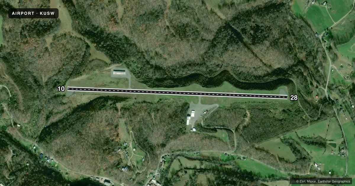
Runways & pattern
Full pagePattern entry · RWY 10
LEFT TRAFFICRunway end performance
| End | TORA | TODA | ASDA | LDA | VGSI | Approach lights | Obstruction |
|---|---|---|---|---|---|---|---|
| 28 | — | — | — | — | — | — | 160', gnd, 4200' from thr, 0' R of cntrln, slope 25 |
Declared distances in feet. TORA = takeoff run available, TODA = takeoff distance, ASDA = accelerate-stop, LDA = landing distance.
Airport sketch
Runways drawn to scale from FAA survey coordinates, rendered over satellite imagery. Not for navigation.
Approaches & charts
Services on the field
Fuel grades, oxygen, maintenance, ramp storage and lighting — as declared to the FAA by the airport operator.
Fuel & services
- Fuel
- 100LLA
- Airframe repair
- Major
- Power plant repair
- Major
- Other services
- INSTR,RNTL,SURV
Ramp & ground
- Transient storage
- Tie-down
- Hangar
- Lighting schedule
- SEE RMK
- Beacon schedule
- SEE RMK
- Beacon
- White / Green (civil land)(WG)
- Wind indicator
- Lighted
- Segmented circle
- No
Fuel & FBOs
Cheapest 100LL and Jet A on the field and nearby. Always confirm with the FBO before taxi.
Airport notes
Surface conditions, obstructions, local procedures, lighting outages and other notes published with each FAA cycle.
General notes
- WILDLIFE & DEER ON & INVOF RWY.
- NSTD RWY SAFETY AREA, 50 FT HILL, 170 FT FROM EACH SIDE OF RWY CL.
- OCNL RC MODEL ACFT OPS ON RWY MIDFIELD.
- FOR CD CTC CHARLESTON APCH AT 304-344-5867 EXT 281.
Lighting notes
- ACTVT ROTG BCN - CTAF.
- ACTVT MIRL RWY 10/28 - CTAF.
Fuel notes
- 100LLFUEL 24 HR SELF SERVICE.
Approach & departure obstructions
- 1010 FT BRUSH, 30 FT DSTC.
- 2810 FT BRUSH, 30 FT DSTC.
- 10PVMNT MKG FADED.
- 28PVMNT MKG FADED.
Other notes
- SEE AIRSPACE LTR DTD 11/6/98 FOR CONDITIONS.
- TPA SINGLE/MULTI ENG ACFT 1000 FT, TURBINE/LARGE ACFT 1500 FT.
- MANAGERARPT PHYSICAL ADDRESS 217 AIRFIELD RD., SPENCER, WV 25726.
VFR map & nearby airports
VFR sectional. Tap any ICAO chip to open that airport.
Key facts · KUSW
Answer card- ICAO
- KUSW
- Name
- BOGGS FLD
- Location
- SPENCER, WEST VIRGINIA
- Elevation
- 928.3 ft MSL
- Traffic pattern altitude
- 1,928.3 ft MSL (1,000 AGL)
- Control tower
- Non-towered (use CTAF)
- Total runways
- 1
- Longest runway
- 10/28 · 4,549 ft
- Published ILS approaches
- 0
- Published frequencies
- 4
- Magnetic variation
- 8°
- Current flight rules
- LIFR
- Current wind
- 000° at 0 kt
- Favored runway now
- –
BOGGS FLD sits in Spencer, West Virginia. The field elevation is 928.3 ft MSL. It has one runway, 10/28, which is 4,549 ft long on asphalt. There is no control tower. Approach and departure service is handled by Charleston on 124.1 and 269.125. No ILS approaches are published here.
For light piston traffic, the published pattern altitude is 1,000 ft AGL. The remarks also list 1,500 ft for turbine and large aircraft. Medium intensity runway lights on 10/28 are pilot-activated on CTAF. The rotating beacon is also CTAF-activated. Fuel is available 24 hours by self-service. That matters if you are planning an early arrival or a late departure.
There are no on-field FBOs listed in the facts. Check with the airport operator or the FBO directly by phone before arrival if you need services. The published remarks also note brush near both runway ends. They note faded markings on both runway directions. They also note occasional model aircraft activity on the runway midfield. First-time visitors should review the current Chart Supplement and the airspace letter dated November 6, 1998 before flying in. Clearance delivery is handled through Charleston Approach at the published phone number in the remarks.