METAR & TAF KGAS
KGAS does not publish a METAR.
Showing the nearest reporting station: KJRO (JAMES A RHODES) · 21.3 NM away. Conditions at KGAS may differ.
METAR · KJRO
Observed 15:15Z
KJRO 271515Z AUTO 31004KT 10SM CLR 26/25 A2995 RMK AO2
- Wind
- 310° @ 4 kt
- Visibility
- 10 SM
- Temp / Dew
- 26°C / 25°C
- Altimeter
- 29.95 inHg
- Clouds
- CLR
- Density alt
- 1,985 ft
- Ceiling
- Unlimited
- Rules
- VFR
Airport info & contacts
Manager on record, flight service, ARTCC, attendance schedule and pattern altitude — published by the FAA and refreshed every 28 days.
Location
- From city
- 2 NM NE
- VFR sectional
- CINCINNATI
- ARTCC
- ZID · INDIANAPOLIS
- NOTAM facility
- DAY (NOTAM-D)
Airport manager
- Name
- KALEB ARMS
- Phone
- 740-446-9004
- Address
- 312 AIRPORT RD, GALLIPOLIS OH 45631
Flight service · Hours
- FSS DAY
- DAYTON1-800-WX-BRIEF
- Attendance
- MON-FRI · 0900-1700
Frequencies
Tap any row to copy the frequency to your clipboard.
Runways & pattern
Full pagePattern entry · RWY 23
LEFT TRAFFICRunway end performance
| End | TORA | TODA | ASDA | LDA | VGSI | Approach lights | Obstruction |
|---|---|---|---|---|---|---|---|
| 05 | — | — | — | — | PAPI 2-box left(3°) | — | 45', tree, 660' from thr, 213' R of cntrln, slope 10 |
| 23 | — | — | — | — | PAPI 2-box left(3°) | — | 10', tree, 205' from thr, 0' R of cntrln, slope 0 |
Declared distances in feet. TORA = takeoff run available, TODA = takeoff distance, ASDA = accelerate-stop, LDA = landing distance.
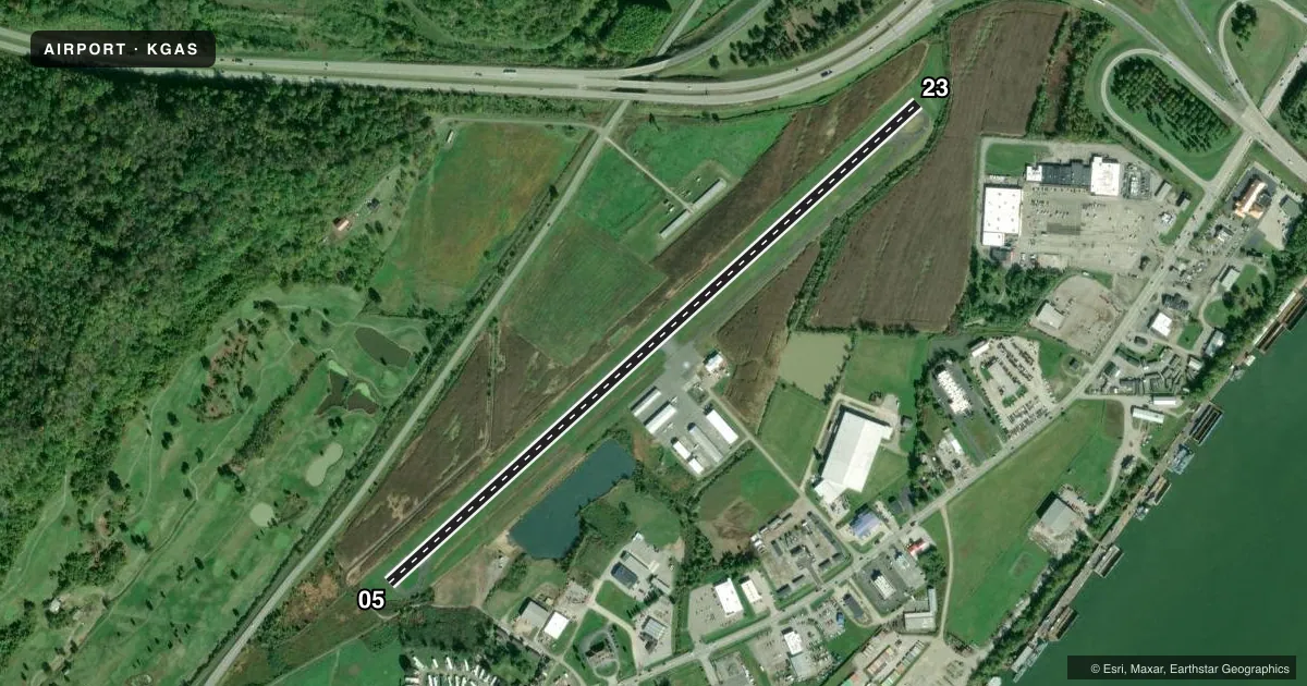
Airport sketch
Runways drawn to scale from FAA survey coordinates, rendered over satellite imagery. Not for navigation.
Approaches & charts
Services on the field
Fuel grades, oxygen, maintenance, ramp storage and lighting — as declared to the FAA by the airport operator.
Fuel & services
- Fuel
- 100LLA1
- Oxygen (bottled)
- Not available
- Oxygen (bulk)
- Not available
- Airframe repair
- Not available
- Power plant repair
- Not available
Ramp & ground
- Transient storage
- Tie-down
- Landing fee
- No fee published
- Customs
- Not available
- Lighting schedule
- SEE RMK
- Beacon schedule
- SS-SR
- Beacon
- White / Green (civil land)(WG)
- Wind indicator
- Lighted
- Segmented circle
- No
Fuel & FBOs
Cheapest 100LL and Jet A on the field and nearby. Always confirm with the FBO before taxi.
Airport notes
Surface conditions, obstructions, local procedures, lighting outages and other notes published with each FAA cycle.
General notes
- DEER & BIRDS ON & INVOF ARPT.
- PARL TWY HAS LRG CRACKS & LOOSE GRVL.
- FOR CD CTC HUNTINGTON ATCT AT 304-453-2490.
Lighting notes
- ACTVT REIL RWY 23; PAPI RWY 05 & 23; MIRL RWY 05/23 - CTAF.
Fuel notes
- 100LL100LL & A1 AVBL H24 SELF SER VIA CREDIT CARD.
Approach & departure obstructions
- 05+10 FT ROAD, 170 FT DIST, L/R OF CNTRLN.
- 23+5-17 FT TREES, 5-145 FT DIST, 75-181 FT L.
- 05CTLG OBSTN EXCEEDS A 45 DEG SLP.
Other notes
- THIS AIRPORT HAS BEEN SURVEYED BY THE NATIONAL GEODETIC SURVEY.
- 2UNATNDD THANKSGIVING, CHRISTMAS, & NEW YEARS DAY.
- MANAGERKARMS@GALLIANET.NET.
- OWNERGCBOC@GALLIANET.NET.
VFR map & nearby airports
VFR sectional. Tap any ICAO chip to open that airport.
Key facts · KGAS
Answer card- ICAO
- KGAS
- Name
- GALLIA-MEIGS RGNL
- Location
- GALLIPOLIS, OHIO
- Elevation
- 565.9 ft MSL
- Traffic pattern altitude
- 1,565.9 ft MSL (1,000 AGL)
- Control tower
- Non-towered (use CTAF)
- Total runways
- 1
- Longest runway
- 05/23 · 3,999 ft
- Published ILS approaches
- 0
- Published frequencies
- 5
- Magnetic variation
- 7°
- Current flight rules
- VFR
- Current wind
- 310° at 4 kt
- Favored runway now
- RWY 23
Gallia-Meigs Regional Airport sits in Gallipolis, Ohio. Field elevation is 565.9 ft MSL. The airport has one runway, 05/23, which is 3,999 ft long. There is no control tower. Use CTAF 123.0 for local traffic. Plan on the Huntington approach frequencies for IFR services. No ILS approaches are published here.
Pattern altitude is not published. For light piston operations, use the standard 1,000 ft AGL pattern unless current local guidance says otherwise. That puts the pattern at about 1,566 ft MSL. The runway lighting is useful after dark. Runway 23 has runway end identifier lights. Runways 05 and 23 have precision approach path indicators. Medium intensity runway lights are installed on 05/23.
Gallia-Meigs Regional Airport has one on-field FBO, Gallia-Meigs Regional Airport. It carries 100LL, Jet A and Jet A Prist. Self-serve fuel is available 24 hours a day by credit card. First-time visitors should also note the published obstructions near both ends of the runway. There is a road near the 05 end. Trees are reported near the 23 end. The parallel taxiway has large cracks and loose gravel. Deer and birds are also reported on and near the field. For clearance delivery, contact Huntington tower. The airport is unattended on Thanksgiving, Christmas and New Year's Day.