METAR & TAF KDWU
Current METAR
Observed 03:56Z
KDWU 270356Z AUTO 00000KT 9SM BKN044 22/21 A2992 RMK AO2 SLP128 T02220211 $
- Wind
- 000° @ 0 kt
- Visibility
- 9 SM
- Temp / Dew
- 22°C / 21°C
- Altimeter
- 29.92 inHg
- Clouds
- BKN
- Density alt
- 1,518 ft
- Ceiling
- 4,400 ft AGL
- Rules
- VFR
Airport info & contacts
Manager on record, flight service, ARTCC, attendance schedule and pattern altitude — published by the FAA and refreshed every 28 days.
Location
- From city
- 6 NM NW
- VFR sectional
- CINCINNATI
- ARTCC
- ZID · INDIANAPOLIS
- NOTAM facility
- LOU (NOTAM-D)
Airport manager
- Name
- SCOTT DARIN
- Phone
- 606-369-0576
- Address
- 501 SCOTT ST, WORTHINGTON KY 41183
Flight service · Hours
- FSS LOU
- LOUISVILLE1-800-WX-BRIEF
- Attendance
- 0800-1800
Frequencies
Tap any row to copy the frequency to your clipboard.
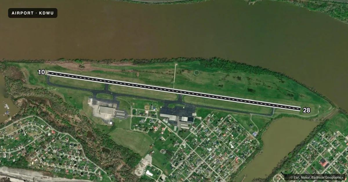
Runways & pattern
Full pagePattern entry · RWY 10
LEFT TRAFFICRunway end performance
| End | TORA | TODA | ASDA | LDA | VGSI | Approach lights | Obstruction |
|---|---|---|---|---|---|---|---|
| 10 | — | — | — | — | PAPI 2-box left(3°) | — | 20', trees, 215' from thr, 179' R of cntrln, slope 0 |
| 28 | — | — | — | — | PAPI 2-box left(4°) | — | 30', trees, 224' from thr, 183' R of cntrln, slope 0 |
Declared distances in feet. TORA = takeoff run available, TODA = takeoff distance, ASDA = accelerate-stop, LDA = landing distance.
Airport sketch
Runways drawn to scale from FAA survey coordinates, rendered over satellite imagery. Not for navigation.
Approaches & charts
Services on the field
Fuel grades, oxygen, maintenance, ramp storage and lighting — as declared to the FAA by the airport operator.
Fuel & services
- Fuel
- 100LLA
- Airframe repair
- Not available
- Power plant repair
- Not available
- Other services
- INSTR,RNTL
Ramp & ground
- Transient storage
- Tie-down
- Hangar
- Landing fee
- Yes
- Customs
- Not available
- Lighting schedule
- SEE RMK
- Beacon schedule
- SS-SR
- Beacon
- White / Green (civil land)(WG)
- Wind indicator
- Lighted
- Segmented circle
- Yes
Fuel & FBOs
Cheapest 100LL and Jet A on the field and nearby. Always confirm with the FBO before taxi.
Airport notes
Surface conditions, obstructions, local procedures, lighting outages and other notes published with each FAA cycle.
General notes
- BIRDS ON & INVOF ARPT.
- FOR CD CTC HUNTINGTON ATCT AT 304-453-2490.
Lighting notes
- ACTVT REIL RWY 10 & 28; MIRL RWY 10/28 - CTAF. PAPI RWY 10 & 28 ON CONSLY.
Approach & departure obstructions
- 28RDO TWR LCTD 10560 FT FM RWY END.
- 10CTLNG OBSTN EXCEEDS A 45 DEG SLP.
Other notes
- EXISTED PRIOR TO 1959.
- OWNERDAVID MANSFIELD
- MANAGERCELLPHONE
- OWNERBRAD MCGINIS - BOARD CHAIR
VFR map & nearby airports
VFR sectional. Tap any ICAO chip to open that airport.
Key facts · KDWU
Answer card- ICAO
- KDWU
- Name
- ASHLAND RGNL
- Location
- ASHLAND, KENTUCKY
- Elevation
- 546.7 ft MSL
- Traffic pattern altitude
- 1,546.7 ft MSL (1,000 AGL)
- Control tower
- Non-towered (use CTAF)
- Total runways
- 1
- Longest runway
- 10/28 · 5,402 ft
- Published ILS approaches
- 0
- Published frequencies
- 5
- Magnetic variation
- 5°
- Current flight rules
- VFR
- Current wind
- 000° at 0 kt
- Favored runway now
- –
Ashland Regional Airport is in Ashland, Kentucky. The field elevation is 546.7 ft MSL. It has one runway, 10/28, which is 5,402 ft long and asphalt. The airport is non-towered. CTAF and UNICOM are 122.8. Clearance delivery is handled through Huntington Air Traffic Control Tower on 121.7 for CD/P. Approach and departure are on 128.4 and 270.1. No ILS approaches are published here.
Pattern altitude is not published. Use 1,000 ft AGL for light piston operations unless the current Chart Supplement says otherwise. The on-field FBO is Ashland Regional Airport. It carries 100LL, Jet A and Jet A Prist. Call ahead at (606) 494-2034 for current service details.
A few operational notes matter here. Birds are reported on and near the airport. There is a radio tower 10,560 ft from the runway 28 end. The published remarks also note a controlling obstruction that exceeds a 45 degree slope. Runway end identifier lights are available on both ends. Medium intensity runway lights on 10 and 28 operate on CTAF. PAPI is on continuously for both runway ends. For a first visit, brief the lighting and obstacle picture before you go. Check the current Chart Supplement for any additional local procedures before flying in.