METAR & TAF KHTW
KHTW does not publish a METAR.
Showing the nearest reporting station: KHTS (TRI-STATE/MILTON J FERGUSON FLD) · 4.3 NM away. Conditions at KHTW may differ.
METAR · KHTS
Observed 11:36Z
KHTS 271136Z 00000KT 1/4SM FG VV002 21/21 A2994 RMK AO2 T02110206 $
- Wind
- 000° @ 0 kt
- Visibility
- 0.25 SM
- Temp / Dew
- 21°C / 21°C
- Altimeter
- 29.94 inHg
- Clouds
- VV
- Density alt
- 1,398 ft
- Ceiling
- 200 ft AGL
- Rules
- LIFR
Airport info & contacts
Manager on record, flight service, ARTCC, attendance schedule and pattern altitude — published by the FAA and refreshed every 28 days.
Location
- From city
- 2 NM W
- VFR sectional
- CINCINNATI
- Pattern altitude
- 1,040 ft AGL · 1,607 ft MSL
- ARTCC
- ZID · INDIANAPOLIS
- NOTAM facility
- DAY (NOTAM-D)
Airport manager
- Name
- BILL NENNI
- Phone
- 740-532-3309
- Address
- 304 N 7TH ST, IRONTON OH 45638-1468
Flight service · Hours
- FSS DAY
- DAYTON1-800-WX-BRIEF
- Attendance
- Unattended
Frequencies
Tap any row to copy the frequency to your clipboard.
Runways & pattern
Full pagePattern entry · RWY 08
LEFT TRAFFICRunway end performance
| End | TORA | TODA | ASDA | LDA | VGSI | Approach lights | Obstruction |
|---|---|---|---|---|---|---|---|
| 08 | — | — | — | — | — | — | 56', trees, 619' from thr, 125' R of cntrln, slope 7 |
Declared distances in feet. TORA = takeoff run available, TODA = takeoff distance, ASDA = accelerate-stop, LDA = landing distance.
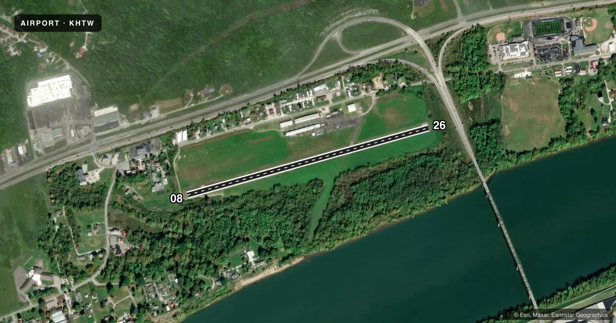
Airport sketch
Runways drawn to scale from FAA survey coordinates, rendered over satellite imagery. Not for navigation.
Approaches & charts
Services on the field
Fuel grades, oxygen, maintenance, ramp storage and lighting — as declared to the FAA by the airport operator.
Fuel & services
- Fuel
- 100LL
- Oxygen (bottled)
- Not available
- Oxygen (bulk)
- Not available
- Airframe repair
- Minor
- Power plant repair
- Minor
- Other services
- INSTR,RNTL
Ramp & ground
- Transient storage
- Tie-down
- Landing fee
- No fee published
- Customs
- Not available
- Lighting schedule
- SEE RMK
- Beacon schedule
- SS-SR
- Beacon
- White / Green (civil land)(WG)
- Wind indicator
- Lighted
- Segmented circle
- No
Fuel & FBOs
Cheapest 100LL and Jet A on the field and nearby. Always confirm with the FBO before taxi.
Airport notes
Surface conditions, obstructions, local procedures, lighting outages and other notes published with each FAA cycle.
General notes
- FOR CD CTC HUNTINGTON ATCT AT 304-453-2490.
Lighting notes
- ACTVT MIRL RWY 08/26 - CTAF.
Fuel notes
- 100LL100LL AVBL H24 SELF SVC VIA CREDIT CARD.
Approach & departure obstructions
- 08+10 FT ROAD, 0 FT DIST, 45 FT R; +12-20 FT TREES, 0-75 FT DIST, 85 FT R; +10-15 FT BRUSH, 85-150 FT DIST, 90 FT L.
- 26+1-8 FT BRUSH & VEGETATION, 63 FT DIST EXTDG TO DROP-OFF, 125 FT L/R.
- 08APCH SLP 14:1 TO DTHR OVR +56 FT TREE, 619 FT DIST, 125 FT R.
Other notes
- ESTABD BFR 1959.
VFR map & nearby airports
VFR sectional. Tap any ICAO chip to open that airport.
Key facts · KHTW
Answer card- ICAO
- KHTW
- Name
- LAWRENCE COUNTY AIRPARK
- Location
- CHESAPEAKE/HUNTINGTON WVA, OHIO
- Elevation
- 567.1 ft MSL
- Traffic pattern altitude
- 1,607.1 ft MSL (1,040 AGL)
- Control tower
- Non-towered (use CTAF)
- Total runways
- 1
- Longest runway
- 08/26 · 2,998 ft
- Published ILS approaches
- 0
- Published frequencies
- 2
- Magnetic variation
- 5°
- Current flight rules
- LIFR
- Current wind
- 000° at 0 kt
- Favored runway now
- –
Lawrence County Airpark sits in Chesapeake and Huntington, West Virginia. The field elevation is 567.1 ft MSL. It has one runway, 08/26, which is 2,998 ft long and asphalt. There is no control tower. CTAF and UNICOM are both 122.7. No ILS approaches are published.
Pattern altitude is 1,040 ft AGL. That is 1,607.1 ft MSL. Medium intensity runway lights for 08/26 are pilot activated on the CTAF. 100LL is available 24 hours a day by self-serve credit card. There are no on-field FBOs listed. Plan ahead and verify any service needs with the airport operator or the FBO directly by phone before arrival.
The published remarks matter here. On runway 08, there is a tree near the displaced threshold area that affects the approach slope. There are also roads, trees and brush close to the runway environment on the 08 side. On runway 26, brush and vegetation sit close to the runway with a drop-off beyond. This is a field where a first-time pilot should brief the runway environment carefully, especially at night or in marginal visibility. If you need clearance delivery, the published remark says to contact Huntington tower at 304-453-2490. Check the current FAA Chart Supplement for any updated operational notes before you go.