METAR & TAF KHTS
Current METAR
Observed 14:51Z
KHTS 271451Z 34003KT 6SM HZ FEW015 26/21 A2995 RMK AO2 SLP133 T02610206 50002
- Wind
- 340° @ 3 kt
- Visibility
- 6 SM
- Temp / Dew
- 26°C / 21°C
- Altimeter
- 29.95 inHg
- Clouds
- FEW
- Density alt
- 2,310 ft
- Ceiling
- Unlimited
- Rules
- VFR
Airport info & contacts
Manager on record, flight service, ARTCC, attendance schedule and pattern altitude — published by the FAA and refreshed every 28 days.
Location
- From city
- 3 NM S
- VFR sectional
- CINCINNATI
- ARTCC
- ZID · INDIANAPOLIS
- NOTAM facility
- HTS (NOTAM-D)
Airport manager
- Name
- BRENT BROWN
- Phone
- 304-453-6165
- Address
- 1449 AIRPORT ROAD, HUNTINGTON WV 25704
Flight service · Hours
- FSS EKN
- ELKINS703-724-42881-800-WX-BRIEF
- Attendance
- ALL
Frequencies
Tap any row to copy the frequency to your clipboard.
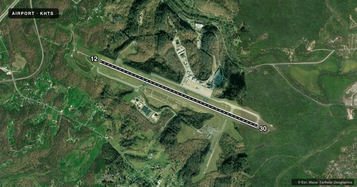
Runways & pattern
Full pagePattern entry · RWY 30
LEFT TRAFFICRunway end performance
| End | TORA | TODA | ASDA | LDA | VGSI | Approach lights | Obstruction |
|---|---|---|---|---|---|---|---|
| 12 | 7,017' | 7,017' | 6,516' | 6,516' | PAPI 4-box left(3°) | MALSR | 36', trees, 950' from thr, 400' R of cntrln, slope 21 |
| 30 | 7,017' | 7,017' | 7,017' | 6,516' | PAPI 4-box left(3°) | — | — |
Declared distances in feet. TORA = takeoff run available, TODA = takeoff distance, ASDA = accelerate-stop, LDA = landing distance.
Airport sketch
Runways drawn to scale from FAA survey coordinates, rendered over satellite imagery. Not for navigation.
Approaches & charts
ILS · 2
Services on the field
Fuel grades, oxygen, maintenance, ramp storage and lighting — as declared to the FAA by the airport operator.
Fuel & services
- Fuel
- 100LLA
- Oxygen (bottled)
- HIGH/LOW
- Oxygen (bulk)
- Not available
- Airframe repair
- Major
- Power plant repair
- Major
- Other services
- CARGO,CHTR,INSTR,SALES
Ramp & ground
- Transient storage
- Tie-down
- Hangar
- Landing fee
- Yes
- Customs
- Not available
- Beacon schedule
- SS-SR
- Beacon
- White / Green (civil land)(WG)
- Wind indicator
- Lighted
- Segmented circle
- No
Fuel & FBOs
Cheapest 100LL and Jet A on the field and nearby. Always confirm with the FBO before taxi.
Airport notes
Surface conditions, obstructions, local procedures, lighting outages and other notes published with each FAA cycle.
General notes
- PILOTS REPORT POSSIBILITY OF MISTAKING FUEL BURNING STACK LCTD APRXLY 2 MI W RY 12 FOR APCH LGTG SFL.
- RY 12 OBSTN TWR LCTD 5100 FT W 600 FT N END RY.
- BIRDS & DEER ON & INVOF ARPT.
Runway surface & condition
- 12/30PCR VALUE: 470/F/A/W/T
Approach & departure obstructions
- 30RY 30 P4L UNUSBL BYD 7 DEGS LEFT OF CNTRLN.
Other notes
- EXISTED PRIOR TO 1959.
- FEE FOR ACFT UNLESS FUEL PURCHASED.
VFR map & nearby airports
VFR sectional. Tap any ICAO chip to open that airport.
Key facts · KHTS
Answer card- ICAO
- KHTS
- Name
- TRI-STATE/MILTON J FERGUSON FLD
- Location
- HUNTINGTON, WEST VIRGINIA
- Elevation
- 828.3 ft MSL
- Traffic pattern altitude
- 1,828.3 ft MSL (1,000 AGL)
- Control tower
- Towered · 24
- Total runways
- 1
- Longest runway
- 12/30 · 7,017 ft
- Published ILS approaches
- 2
- Published frequencies
- 14
- Magnetic variation
- 6°
- Current flight rules
- VFR
- Current wind
- 340° at 3 kt
- Favored runway now
- RWY 30
TRI-STATE / MILTON J FERGUSON FLD sits in Huntington, West Virginia. Field elevation is 828.3 ft MSL. The airport has one runway, 12/30, which is 7,017 ft long and asphalt. The tower is open 24 hours. Two ILS approaches are published, one for runway 12 and one for runway 30.
Pattern altitude is not published in the facts. Use standard 1,000 ft AGL for light piston operations unless ATC or the current Chart Supplement says otherwise. That puts the normal pattern reference at about 1,828 ft MSL based on the field elevation. Huntington Jet Center is on the field. It carries 100LL, Jet A and Jet A Prist. Call (304) 453-6165 for current service details.
A few local items matter here. Pilots have reported a fuel burning stack about 2 miles west of runway 12 that can be mistaken for approach lighting at a glance. Birds and deer are reported on and near the airport. Runway 30 PAPI is unusable beyond 7 degrees left of centerline. There is also a fee for aircraft unless fuel is purchased. Check the current FAA Chart Supplement for any published noise or curfew restrictions before flying in. The airport has been in service since before 1959. Expect a mature field layout and normal towered-airport traffic flow.