METAR & TAF KSJS
Current METAR
Observed 21:55Z
KSJS 262155Z AUTO 27003KT 10SM SCT050 28/20 A2994 RMK AO2 T02750202
- Wind
- 270° @ 3 kt
- Visibility
- 10 SM
- Temp / Dew
- 28°C / 20°C
- Altimeter
- 29.94 inHg
- Clouds
- SCT
- Density alt
- 3,050 ft
- Ceiling
- Unlimited
- Rules
- VFR
Airport info & contacts
Manager on record, flight service, ARTCC, attendance schedule and pattern altitude — published by the FAA and refreshed every 28 days.
Location
- From city
- 9 NM NE
- VFR sectional
- CINCINNATI
- ARTCC
- ZID · INDIANAPOLIS
- NOTAM facility
- LOU (NOTAM-D)
Airport manager
- Name
- GARY COX
- Phone
- 606-298-5930
- Address
- 2960 AIRPORT ROAD, DEBORD KY 41214
Flight service · Hours
- FSS LOU
- LOUISVILLE1-800-WX-BRIEF
- Attendance
- 0800-DUSK
Frequencies
Tap any row to copy the frequency to your clipboard.
Runways & pattern
Full pagePattern entry · RWY 21
LEFT TRAFFICRunway end performance
| End | TORA | TODA | ASDA | LDA | VGSI | Approach lights | Obstruction |
|---|---|---|---|---|---|---|---|
| 03 | — | — | — | — | PAPI 2-box left(4°) | — | 32', tree, 789' from thr, 6' R of cntrln, slope 18 |
| 21 | — | — | — | — | PAPI 2-box left(3°) | — | — |
Declared distances in feet. TORA = takeoff run available, TODA = takeoff distance, ASDA = accelerate-stop, LDA = landing distance.
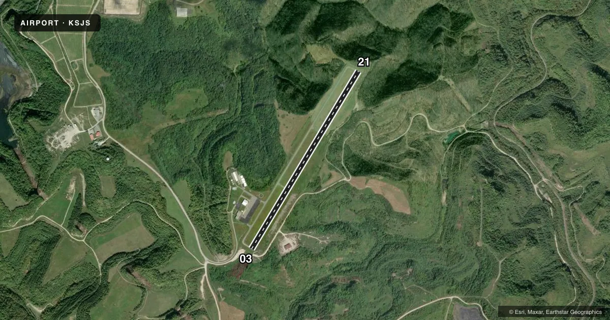
Airport sketch
Runways drawn to scale from FAA survey coordinates, rendered over satellite imagery. Not for navigation.
Approaches & charts
Services on the field
Fuel grades, oxygen, maintenance, ramp storage and lighting — as declared to the FAA by the airport operator.
Fuel & services
- Fuel
- 100LLA+
- Other services
- AMB
Ramp & ground
- Transient storage
- Tie-down
- Lighting schedule
- SEE RMK
- Beacon schedule
- SS-SR
- Beacon
- White / Green (civil land)(WG)
- Wind indicator
- Lighted
- Segmented circle
- Yes
Fuel & FBOs
Cheapest 100LL and Jet A on the field and nearby. Always confirm with the FBO before taxi.
Airport notes
Surface conditions, obstructions, local procedures, lighting outages and other notes published with each FAA cycle.
General notes
- BIRDS & DEER ON & INVOF ARPT.
- FOR CD CTC HUNTINGTON ATCT AT 304-453-2490.
Lighting notes
- ACTVT REIL RWY 03 & 21; MIRL RWY 03/21 - CTAF. PAPI RWY 03 & 21 OPR CONSLY.
Approach & departure obstructions
- 03PAPI UNUSBL BYD 6 DEGS RIGHT OF CNTRLN.
Other notes
- MANAGERAFT HRS SVC 606-371-3793. LANDLINE TSFR TO GARY'S CELL.
- OWNERARPT BOARD CHAIRMAN. JERRY PRICE
VFR map & nearby airports
VFR sectional. Tap any ICAO chip to open that airport.
Key facts · KSJS
Answer card- ICAO
- KSJS
- Name
- BIG SANDY RGNL
- Location
- PRESTONSBURG, KENTUCKY
- Elevation
- 1,221.5 ft MSL
- Traffic pattern altitude
- 2,221.5 ft MSL (1,000 AGL)
- Control tower
- Non-towered (use CTAF)
- Total runways
- 1
- Longest runway
- 03/21 · 5,051 ft
- Published ILS approaches
- 0
- Published frequencies
- 4
- Magnetic variation
- 5°
- Current flight rules
- VFR
- Current wind
- 270° at 3 kt
- Favored runway now
- RWY 21
Big Sandy Rgnl Airport is in Prestonsburg, Kentucky. The field elevation is 1,221.5 ft MSL. It has one runway, 03/21, which is 5,051 ft long. There is no control tower. Traffic uses CTAF 123.05, which is also the UNICOM frequency. No ILS approaches are published here.
The published pattern altitude is not listed, so use the standard 1,000 ft AGL pattern unless the current Chart Supplement says otherwise. That puts the light aircraft pattern at 2,221.5 ft MSL based on the field elevation. Cox Aviation is on the field. It carries 100LL and Jet A. For after-hours service, the published number is 606-371-3793. The airport also notes that the line transfers to Gary's cell phone.
A few operational notes matter here. Runway end identifier lights are installed on 03 and 21. The medium intensity runway lights are controlled by CTAF. The PAPI on 03 and 21 runs continuously. The published remark also says the PAPI on runway 03 is unusable beyond 6 degrees right of centerline. Birds and deer are reported on and near the airport. For clearance delivery, contact Huntington ATC at 304-453-2490. If you need current noise or local operating guidance, check the current FAA Chart Supplement before you go.