METAR & TAF KEBD
KEBD does not publish a METAR.
Showing the nearest reporting station: KPBX (PIKE COUNTY/HATCHER FLD) · 22.3 NM away. Conditions at KEBD may differ.
METAR · KPBX
Observed 11:35Z
KPBX 271135Z AUTO 00000KT M1/4SM FG OVC001 21/21 A2996 RMK AO2 T02100207
- Wind
- 000° @ 0 kt
- Visibility
- —
- Temp / Dew
- 21°C / 21°C
- Altimeter
- 29.96 inHg
- Clouds
- OVC
- Density alt
- 3,006 ft
- Ceiling
- 100 ft AGL
- Rules
- LIFR
Airport info & contacts
Manager on record, flight service, ARTCC, attendance schedule and pattern altitude — published by the FAA and refreshed every 28 days.
Location
- From city
- 8 NM E
- VFR sectional
- CINCINNATI
- ARTCC
- ZID · INDIANAPOLIS
- NOTAM facility
- EKN (NOTAM-D)
Airport manager
- Name
- LEIGH ANN WELLS-RAY
- Phone
- 304-235-0338
- Address
- MINGO COUNTY AIRPORT AUTHORITY, MINGO COUNTY COURTHOUSE, WILLLIAMSON WV 25661
Flight service · Hours
- FSS EKN
- ELKINS703-724-42881-800-WX-BRIEF
- Attendance
- Unattended
Frequencies
Tap any row to copy the frequency to your clipboard.
Runways & pattern
Full pagePattern entry · RWY 08
LEFT TRAFFICRunway end performance
| End | TORA | TODA | ASDA | LDA | VGSI | Approach lights | Obstruction |
|---|---|---|---|---|---|---|---|
| 08 | — | — | — | — | PAPI 2-box left(3°) | — | 30', trees, 201' from thr, 160' R of cntrln, slope 0 |
| 26 | — | — | — | — | PAPI 2-box left(3°) | — | 10', tree, 210' from thr, 162' R of cntrln, slope 0 |
Declared distances in feet. TORA = takeoff run available, TODA = takeoff distance, ASDA = accelerate-stop, LDA = landing distance.
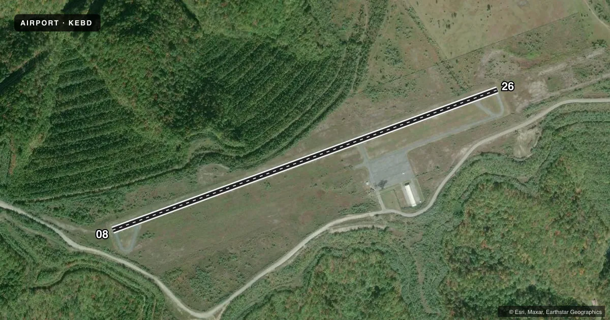
Airport sketch
Runways drawn to scale from FAA survey coordinates, rendered over satellite imagery. Not for navigation.
Approaches & charts
Services on the field
Fuel grades, oxygen, maintenance, ramp storage and lighting — as declared to the FAA by the airport operator.
Fuel & services
- Fuel
- 100LLA1
Ramp & ground
- Transient storage
- Not published
- Lighting schedule
- SEE RMK
- Beacon schedule
- SS-SR
- Beacon
- White / Green (civil land)(WG)
- Wind indicator
- Lighted
Fuel & FBOs
Cheapest 100LL and Jet A on the field and nearby. Always confirm with the FBO before taxi.
Airport notes
Surface conditions, obstructions, local procedures, lighting outages and other notes published with each FAA cycle.
General notes
- BIRDS, DEER, & BEAR ON & INVOF ARPT.
- NO SNOW REMOVAL.
- NO TRML BLDG OR FAC AVBL. ENTRANCE GATE CLSD & LOCKED. FOR ACES CALL AMGR CELL 606-794-3564.
- FOR CD CTC INDIANAPOLIS ARTCC AT 317-247-2411.
- BRUSH & TREES IN PRIMARY SFC, 42 FT FM RWY EDGE.
- RWY 08 & RWY 26 SUPPLEMENT WINDSOCK NOT VERTICAL, TREES IN VCNTY, READINGS NOT RELBL.
Lighting notes
- ACTVT REIL RWY 08 & 26; PAPI RWY 08 & 26; MIRL RWY 08/26 - CTAF.
Fuel notes
- 100LLFUEL 24 HR SELF-SERV ONLY.
Approach & departure obstructions
- 0820 FT TREES; 0 FT DSTC.
- 2612 FT TREES; UP TO 199 FT DSTC, 75 FT LEFT.
- 08CTLNG OBSTN EXCEEDS A 45 DEG SLP.
VFR map & nearby airports
VFR sectional. Tap any ICAO chip to open that airport.
Key facts · KEBD
Answer card- ICAO
- KEBD
- Name
- SOUTHERN WEST VIRGINIA RGNL
- Location
- WILLIAMSON, WEST VIRGINIA
- Elevation
- 1,883.2 ft MSL
- Traffic pattern altitude
- 2,883.2 ft MSL (1,000 AGL)
- Control tower
- Non-towered (use CTAF)
- Total runways
- 1
- Longest runway
- 08/26 · 5,001 ft
- Published ILS approaches
- 0
- Published frequencies
- 2
- Magnetic variation
- 7°
- Current flight rules
- LIFR
- Current wind
- 000° at 0 kt
- Favored runway now
- –
Southern West Virginia Rgnl is in Williamson, West Virginia. The field elevation is 1,883.2 ft MSL. It has one runway. Runway 08/26 is 5,001 ft of asphalt, so plan performance with the elevation in mind. There is no control tower. CTAF and UNICOM are both 122.8.
No ILS approaches are published here. Pattern altitude is not published. Use standard 1,000 ft AGL for light piston traffic unless the current Chart Supplement says otherwise. The airport sits in a terrain and wildlife environment that deserves attention. Trees are near the runway environment. Birds, deer and bear are reported on and near the airport. Runway 08 has obstructions close in. Runway 26 also has trees off the left side.
Fuel is self-service only. 100LL is available 24 hours. There are no on-field FBOs listed. No terminal building or facilities are available. The entrance gate is closed and locked, so call the airport manager at 606-794-3564 if you need access. Runway lights, REILs and PAPI are on runway 08/26 and are controlled by CTAF. Read the windsock situation carefully. The published remarks say the supplemental windsocks are not vertical, so they are not reliable. For clearance delivery, contact Indianapolis ARTCC at 317-247-2411.