METAR & TAF I16
Current METAR
Observed 12:15Z
KI16 271215Z AUTO 10SM OVC003 21/21 A3002 RMK AO2 T02070207
- Wind
- Calm
- Visibility
- 10 SM
- Temp / Dew
- 21°C / 21°C
- Altimeter
- 30.02 inHg
- Clouds
- OVC
- Density alt
- 2,807 ft
- Ceiling
- 300 ft AGL
- Rules
- LIFR
Airport info & contacts
Manager on record, flight service, ARTCC, attendance schedule and pattern altitude — published by the FAA and refreshed every 28 days.
Location
- From city
- 2 NM NW
- VFR sectional
- CINCINNATI
- ARTCC
- ZID · INDIANAPOLIS
- NOTAM facility
- EKN (NOTAM-D)
Airport manager
- Name
- BILLY JOE COOPER
- Phone
- 304-732-9160
- Address
- PO BOX 309, PINEVILLE WV 24874
Flight service · Hours
- FSS EKN
- ELKINS703-724-42881-800-WX-BRIEF
- Attendance
- MON-FRI · 0900-1600
Frequencies
Tap any row to copy the frequency to your clipboard.
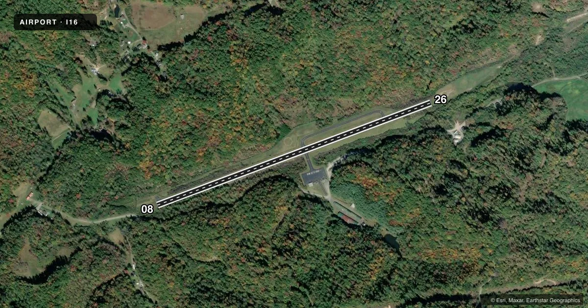
Runways & pattern
Full pagePattern entry · RWY 08
LEFT TRAFFICRunway end performance
| End | TORA | TODA | ASDA | LDA | VGSI | Approach lights | Obstruction |
|---|---|---|---|---|---|---|---|
| 08 | — | — | — | — | — | — | 80', trees, 201' from thr, 120' R of cntrln, slope 0 |
| 26 | — | — | — | — | — | — | 50', trees, 201' from thr, 220' R of cntrln, slope 0 |
Declared distances in feet. TORA = takeoff run available, TODA = takeoff distance, ASDA = accelerate-stop, LDA = landing distance.
Airport sketch
Runways drawn to scale from FAA survey coordinates, rendered over satellite imagery. Not for navigation.
Approaches & charts
Services on the field
Fuel grades, oxygen, maintenance, ramp storage and lighting — as declared to the FAA by the airport operator.
Fuel & services
- Fuel
- 100LL
Ramp & ground
- Transient storage
- Tie-down
- Hangar
- Landing fee
- No fee published
- Customs
- Not available
- Lighting schedule
- SEE RMK
- Beacon schedule
- SS-SR
- Beacon
- White / Green (civil land)(WG)
- Wind indicator
- Lighted
- Segmented circle
- Yes
Fuel & FBOs
Cheapest 100LL and Jet A on the field and nearby. Always confirm with the FBO before taxi.
Airport notes
Surface conditions, obstructions, local procedures, lighting outages and other notes published with each FAA cycle.
General notes
- WILDLIFE ON AND INVOF ARPT.
- LANDFILL MIDPT OF RWY, SOUTH SIDE. BIRDS ON AND INVOF ARPT.
- RISING TERRAIN SURROUNDS ARPT.
- RY SLOPES DOWN 2% FROM E TO W.
- FOR CD CTC INDIANAPOLIS ARTCC AT 317-247-2411.
Lighting notes
- ARPT BCN LCTD 3000' NE ARPT.
- ACTVT MIRL RY 08/26, REIL RYS 08/26 - CTAF.
Approach & departure obstructions
- 0825 FT GND UP TO 200 FT OUT, 120 FT LEFT; 40 FT TREES 0 FT DSTC, 120 FT RIGHT.
- 26RISING GND 4 FT, 75 TO 200 FT DSTC, ACROSS THLD. 30 FT TREES, 0 FT DSTC, 7 FT LEFT & RIGHT.
- 26APCH SLOPE 3:1 AT DTHR; OVR 30 FT TREES 105 FT DSTC, 125 FT RIGHT.
Other notes
- THIS AIRPORT HAS BEEN SURVEYED BY THE NATIONAL GEODETIC SURVEY.
- PILOT PROVIDE OWN ROPES.
- 1UNATND MAJ. HOL. FOR ARPT ATTENDANT AFTER HRS CALL 304-732-7372 (MGR RES).
VFR map & nearby airports
VFR sectional. Tap any ICAO chip to open that airport.
Key facts · I16
Answer card- ICAO
- I16
- Name
- KEE FLD
- Location
- PINEVILLE, WEST VIRGINIA
- Elevation
- 1,783 ft MSL
- Traffic pattern altitude
- 2,783 ft MSL (1,000 AGL)
- Control tower
- Non-towered (use CTAF)
- Total runways
- 1
- Longest runway
- 08/26 · 3,701 ft
- Published ILS approaches
- 0
- Published frequencies
- 4
- Magnetic variation
- 5°
- Current flight rules
- LIFR
- Current wind
- Calm / unavailable
- Favored runway now
- –
Kee Field sits in Pineville, West Virginia. The field elevation is 1,783 ft MSL. It has one runway. The longest runway is 08/26 at 3,701 ft. There is no control tower. No ILS approaches are published here. The pattern altitude is not published, so use the standard 1,000 ft AGL for light piston traffic unless the current Chart Supplement says otherwise.
The on-field FBO is Kee Field. Fuel grades are not reported in the facts provided, so call ahead before you go. The airport is unattended on major holidays. For an airport attendant after hours, the published number is 304-732-7372. The runway lights on 08/26 are medium intensity. REILs on 08/26 are activated by CTAF.
This is a field where terrain matters. Rising terrain surrounds the airport. The runway also slopes down 2 percent from east to west. There are published obstructions on both ends. Wildlife and birds are in the area. The approach to runway 26 has a displaced-threshold slope note with trees close in. Runway 08 also has nearby terrain and trees. Clearance delivery is handled through Indianapolis ARTCC at 317-247-2411. For a first visit, brief the terrain, the runway slope and the obstruction notes before you arrive.