METAR & TAF KPBX
Current METAR
Observed 06:15Z
KPBX 270615Z AUTO 33003KT 10SM BKN026 22/22 A2995 RMK AO2 T02210218
- Wind
- 330° @ 3 kt
- Visibility
- 10 SM
- Temp / Dew
- 22°C / 22°C
- Altimeter
- 29.95 inHg
- Clouds
- BKN
- Density alt
- 2,619 ft
- Ceiling
- 2,600 ft AGL
- Rules
- MVFR
Airport info & contacts
Manager on record, flight service, ARTCC, attendance schedule and pattern altitude — published by the FAA and refreshed every 28 days.
Location
- From city
- 6 NM NW
- VFR sectional
- CINCINNATI
- ARTCC
- ZID · INDIANAPOLIS
- NOTAM facility
- LOU (NOTAM-D)
Airport manager
- Name
- MATT RAY
- Phone
- 606-437-9548
- Address
- 331 AIRPORT DRIVE, PIKEVILLE KY 41501
Flight service · Hours
- FSS LOU
- LOUISVILLE1-800-WX-BRIEF
- Attendance
- SAT-SUN · 0900-1900
- MON-FRI · 0800-2000
Frequencies
Tap any row to copy the frequency to your clipboard.
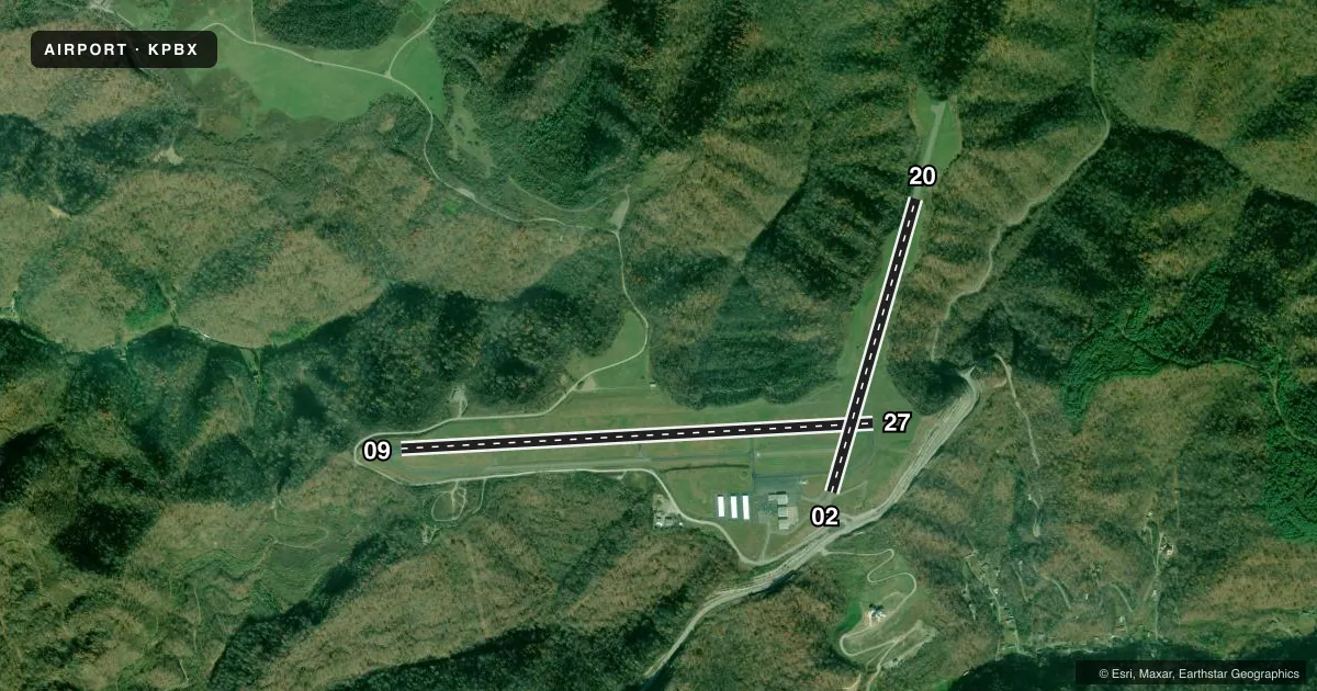
Runways & pattern
Full pagePattern entry · RWY 02
LEFT TRAFFIC| Runway | Heading (°M) | Length | Surface | Traffic |
|---|---|---|---|---|
| 09/27 | 80° / 260° | 5,356 ft | ASPH | Standard L |
| 02/20Favored | 9° / 189° | 3,455 ft | ASPH | Standard L |
Runway end performance
| End | TORA | TODA | ASDA | LDA | VGSI | Approach lights | Obstruction |
|---|---|---|---|---|---|---|---|
| 09 | 5,350' | 5,350' | 5,000' | 4,650' | PAPI 4-box left(3°) | — | 10', tree, 204' from thr, 279' R of cntrln, slope 0 |
| 27 | 5,350' | 5,350' | 5,000' | 4,650' | PAPI 4-box left(3°) | — | 30', tree, 379' from thr, 359' R of cntrln, slope 5 |
Declared distances in feet. TORA = takeoff run available, TODA = takeoff distance, ASDA = accelerate-stop, LDA = landing distance.
Airport sketch
Runways drawn to scale from FAA survey coordinates, rendered over satellite imagery. Not for navigation.
Approaches & charts
ILS · 1
Services on the field
Fuel grades, oxygen, maintenance, ramp storage and lighting — as declared to the FAA by the airport operator.
Fuel & services
- Fuel
- 100LLA+
- Other services
- INSTR
Ramp & ground
- Transient storage
- Tie-down
- Lighting schedule
- SEE RMK
- Beacon schedule
- SS-SR
- Beacon
- White / Green (civil land)(WG)
- Wind indicator
- Lighted
- Segmented circle
- Yes
Fuel & FBOs
Cheapest 100LL and Jet A on the field and nearby. Always confirm with the FBO before taxi.
Airport notes
Surface conditions, obstructions, local procedures, lighting outages and other notes published with each FAA cycle.
General notes
- FOR CD IF UNA TO CTC ON FSS FREQ, CTC INDIANAPOLIS ARTCC AT 317-247-2411.
Lighting notes
- ACTVT REIL RWY 09 & 27; PAPI RWY 09 & 27; HIRL RWY 09/27 - CTAF.
Runway surface & condition
- 02/20CLSD INDEFLY.
Approach & departure obstructions
- 09PAPI UNUSBL BYD 8 DEG RIGHT OF CNTRLN.
- 09CONTROLLING OBSTN EXCEEDS A 45 DEG SLP.
- 27APCH RATIO 43:1 TO DTHR
Other notes
- VFR USE ONLY.
- 1SVC AFT HR - AMGR.
- 2WINTER HR MON-FRI 0800-1900.
- OWNERBILL HICKMAN.
- 09/27MULT DIPS IN RWY.
VFR map & nearby airports
VFR sectional. Tap any ICAO chip to open that airport.
Key facts · KPBX
Answer card- ICAO
- KPBX
- Name
- PIKE COUNTY/HATCHER FLD
- Location
- PIKEVILLE, KENTUCKY
- Elevation
- 1,464.5 ft MSL
- Traffic pattern altitude
- 2,464.5 ft MSL (1,000 AGL)
- Control tower
- Non-towered (use CTAF)
- Total runways
- 2
- Longest runway
- 09/27 · 5,356 ft
- Published ILS approaches
- 1
- Published frequencies
- 2
- Magnetic variation
- 7°
- Current flight rules
- MVFR
- Current wind
- 330° at 3 kt
- Favored runway now
- RWY 02
PIKE COUNTY/HATCHER FLD is in Pikeville, Kentucky. The field elevation is 1,464.5 ft MSL. It has two runways. The longest is runway 09/27 at 5,356 ft. There is no control tower. CTAF and UNICOM are both 122.8. The airport has one ILS approach. It is for runway 27.
Pattern altitude is not published. Use 1,000 ft AGL for light piston traffic unless the current FAA Chart Supplement says otherwise. This is a VFR-only airport, so plan for visual conditions and keep an eye on terrain and weather in the hills around eastern Kentucky. Runway 02/20 is closed indefinitely. That leaves runway 09/27 as the practical runway for most arrivals and departures.
Pike County Airport is the on-field FBO. It carries 100LL and Jet A. Call (606) 437-9548 for current service details. Published remarks also note that after-hours service is available through the airport manager. Runway 09 has a PAPI that is unusable beyond 8 degrees right of centerline. Runway 09/27 has multiple surface dips. Runway 09 also has a controlling obstruction. Runway end identifier lights, PAPI and high-intensity runway lights are available on 09/27. Lighting is controlled on CTAF. Winter hours are Monday through Friday from 0800 to 1900.