METAR & TAF KJKL
Current METAR
Observed 13:32Z
KJKL 271332Z AUTO 00000KT 4SM BR OVC002 21/20 A2998 RMK AO2 T02060200
- Wind
- 000° @ 0 kt
- Visibility
- 4 SM
- Temp / Dew
- 21°C / 20°C
- Altimeter
- 29.98 inHg
- Clouds
- OVC
- Density alt
- 2,358 ft
- Ceiling
- 200 ft AGL
- Rules
- LIFR
Airport info & contacts
Manager on record, flight service, ARTCC, attendance schedule and pattern altitude — published by the FAA and refreshed every 28 days.
Location
- From city
- 3 NM NE
- VFR sectional
- CINCINNATI
- ARTCC
- ZID · INDIANAPOLIS
- NOTAM facility
- JKL (NOTAM-D)
Airport manager
- Name
- JOHNNY DEATON
- Phone
- (606) 568-5356
- Address
- 208 AIRPORT ROAD, JACKSON KY 41339
Flight service · Hours
- FSS LOU
- LOUISVILLE1-800-WX-BRIEF
- Attendance
- Unattended
Frequencies
Tap any row to copy the frequency to your clipboard.
Runways & pattern
Full pagePattern entry · RWY 01
LEFT TRAFFICRunway end performance
| End | TORA | TODA | ASDA | LDA | VGSI | Approach lights | Obstruction |
|---|---|---|---|---|---|---|---|
| 01 | — | — | — | — | — | — | 48', trees, 177' from thr, 232' R of cntrln, slope 0 |
| 19 | — | — | — | — | — | — | 22', trees, 195' from thr, 111' R of cntrln, slope 0 |
Declared distances in feet. TORA = takeoff run available, TODA = takeoff distance, ASDA = accelerate-stop, LDA = landing distance.
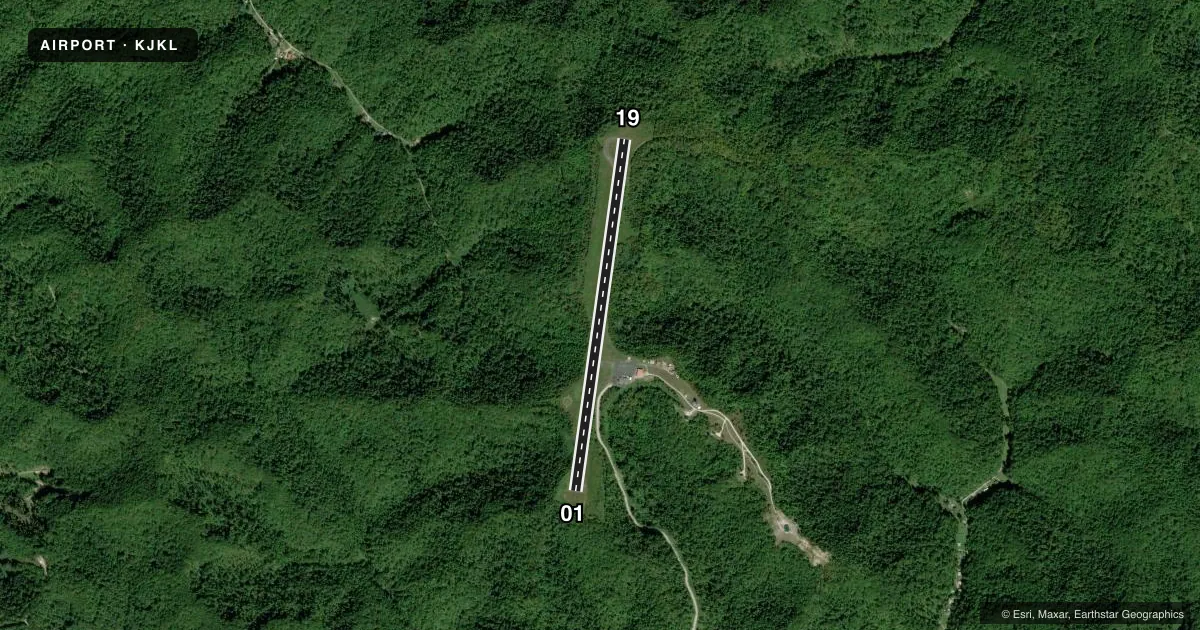
Airport sketch
Runways drawn to scale from FAA survey coordinates, rendered over satellite imagery. Not for navigation.
Approaches & charts
Services on the field
Fuel grades, oxygen, maintenance, ramp storage and lighting — as declared to the FAA by the airport operator.
Fuel & services
- Fuel
- Not available
- Oxygen (bottled)
- Not available
- Oxygen (bulk)
- Not available
- Airframe repair
- Not available
- Power plant repair
- Not available
Ramp & ground
- Transient storage
- Tie-down
- Landing fee
- No fee published
- Lighting schedule
- SEE RMK
- Beacon schedule
- SS-SR
- Beacon
- White / Green (civil land)(WG)
- Wind indicator
- Yes
- Segmented circle
- Yes
Fuel & FBOs
Cheapest 100LL and Jet A on the field and nearby. Always confirm with the FBO before taxi.
Airport notes
Surface conditions, obstructions, local procedures, lighting outages and other notes published with each FAA cycle.
General notes
- FOR CD CTC INDIANAPOLIS ARTCC AT 317-247-2411.
Lighting notes
- ACTVT REIL RWY 01 & 19; MIRL RWY 01/19 - CTAF.
Approach & departure obstructions
- 01TREES AND BRUSH LOCATED WITHIN 200' OF THE THRESHOLD LEFT OF THE APPROACH
- 19TREES AND BRUSH LOCATED WITHIN 200' OF THE THRESHOLD RIGHT OF THE APPROACH
- 01MARKINGS FADED AND ALGAE COVERED
- 19MARKINGS FADED AND ALGAE COVERED
- 01CONTROLLING OBSTN EXCEEDS A 45 DEG SLP.
Other notes
- MANAGERAIRPORT ADDRESS 1333 AIRPORT ROAD, JACKSON KY 41339
- MANAGERARPT BOARD CHAIRMAN JOHNNY MACO DEATON
VFR map & nearby airports
VFR sectional. Tap any ICAO chip to open that airport.
Key facts · KJKL
Answer card- ICAO
- KJKL
- Name
- JULIAN CARROLL
- Location
- JACKSON, KENTUCKY
- Elevation
- 1,380.8 ft MSL
- Traffic pattern altitude
- 2,380.8 ft MSL (1,000 AGL)
- Control tower
- Non-towered (use CTAF)
- Total runways
- 1
- Longest runway
- 01/19 · 4,401 ft
- Published ILS approaches
- 0
- Published frequencies
- 2
- Magnetic variation
- 4°
- Current flight rules
- LIFR
- Current wind
- 000° at 0 kt
- Favored runway now
- –
Julian Carroll Airport sits in Jackson, Kentucky. The field elevation is 1,380.8 ft MSL. It has one runway, 01/19, which is 4,401 ft long and asphalt. The airport is non-towered. CTAF and UNICOM are both 122.8.
No ILS approaches are published here. The pattern altitude is not published, so use standard traffic pattern planning unless the current FAA Chart Supplement says otherwise. Magnetic variation is 4°. Runway headings are 8° and 188° magnetic.
The published remarks matter here. Runway markings on both ends are faded and covered with algae. Runway end identifier lights are installed on 01 and 19. Medium intensity runway lights on 01/19 are CTAF controlled. There are also obstructions near both ends. Trees and brush sit within 200 ft of the threshold on the approach side of runway 01. Trees and brush are also within 200 ft of the threshold to the right of the approach on runway 19. The controlling obstruction for runway 01 exceeds a 45 degree slope.
No on-field FBOs are listed in the facts. Contact the airport operator directly or call the field on CTAF for current service details. For clearance delivery, contact Indianapolis ARTCC at 317-247-2411. The airport board chairman is Johnny Maco Deaton. If you are planning a first visit, pay close attention to the runway condition, the terrain around the approach ends and the lack of published ILS service.