METAR & TAF KSYM
Current METAR
Observed 14:55Z
KSYM 271455Z AUTO 00000KT 10SM CLR 26/21 A2995 RMK AO2
- Wind
- 000° @ 0 kt
- Visibility
- 10 SM
- Temp / Dew
- 26°C / 21°C
- Altimeter
- 29.95 inHg
- Clouds
- CLR
- Density alt
- 2,558 ft
- Ceiling
- Unlimited
- Rules
- VFR
Airport info & contacts
Manager on record, flight service, ARTCC, attendance schedule and pattern altitude — published by the FAA and refreshed every 28 days.
Location
- From city
- 7 NM NW
- VFR sectional
- CINCINNATI
- ARTCC
- ZID · INDIANAPOLIS
- NOTAM facility
- LOU (NOTAM-D)
Airport manager
- Name
- JACK & JODI HOLLEY
- Phone
- 606-780-0085
- Address
- 1800 RODNEY HITCH BLVD, MOREHEAD KY 40351
Flight service · Hours
- FSS LOU
- LOUISVILLE1-800-WX-BRIEF
- Attendance
- SAT · 1000-1600
- SUN · 1300-1600
- MON-FRI · 0800-1600
Frequencies
Tap any row to copy the frequency to your clipboard.
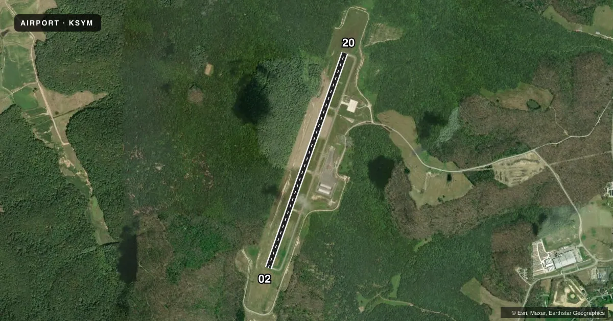
Runways & pattern
Full pagePattern entry · RWY 02
LEFT TRAFFICRunway end performance
| End | TORA | TODA | ASDA | LDA | VGSI | Approach lights | Obstruction |
|---|---|---|---|---|---|---|---|
| 02 | — | — | — | — | PAPI 4-box left(3°) | — | 56', trees, 1622' from thr, 647' R of cntrln, slope 25 |
| 20 | — | — | — | — | PAPI 4-box left(3°) | — | 53', trees, 216' from thr, 456' R of cntrln, slope 0 |
Declared distances in feet. TORA = takeoff run available, TODA = takeoff distance, ASDA = accelerate-stop, LDA = landing distance.
Airport sketch
Runways drawn to scale from FAA survey coordinates, rendered over satellite imagery. Not for navigation.
Approaches & charts
Services on the field
Fuel grades, oxygen, maintenance, ramp storage and lighting — as declared to the FAA by the airport operator.
Fuel & services
- Fuel
- 100LLA+
Ramp & ground
- Transient storage
- Tie-down
- Hangar
- Lighting schedule
- SEE RMK
- Beacon schedule
- SS-SR
- Beacon
- White / Green (civil land)(WG)
- Wind indicator
- Lighted
- Segmented circle
- Yes
Fuel & FBOs
Cheapest 100LL and Jet A on the field and nearby. Always confirm with the FBO before taxi.
Airport notes
Surface conditions, obstructions, local procedures, lighting outages and other notes published with each FAA cycle.
General notes
- FOR CD CTC INDIANAPOLIS ARTCC AT 317-247-2411.
Lighting notes
- ACTVT REIL RWY 02 & 20; PAPI RWY 02 & 20; MIRL RWY 02/20 - CTAF.
Fuel notes
- 100LLFUEL SVC AVBL H24 WITH CREDIT CARD.
Approach & departure obstructions
- 02CONTROLLING OBSTN EXCEEDS A 45 DEG SLP.
Other notes
- OWNERBRUCE MATTINGLY
- MANAGER(606) 776-6211 OR (606) 356-2313.
VFR map & nearby airports
VFR sectional. Tap any ICAO chip to open that airport.
Key facts · KSYM
Answer card- ICAO
- KSYM
- Name
- MOREHEAD-ROWAN COUNTY CLYDE A THOMAS RGNL
- Location
- MOREHEAD, KENTUCKY
- Elevation
- 1,028.4 ft MSL
- Traffic pattern altitude
- 2,028.4 ft MSL (1,000 AGL)
- Control tower
- Non-towered (use CTAF)
- Total runways
- 1
- Longest runway
- 02/20 · 5,500 ft
- Published ILS approaches
- 0
- Published frequencies
- 2
- Magnetic variation
- 6°
- Current flight rules
- VFR
- Current wind
- 000° at 0 kt
- Favored runway now
- –
Morehead-Rowan County Clyde A Thomas Rgnl sits in Morehead, Kentucky at 1,028.4 ft MSL. It has one runway, 02/20, which is 5,500 ft long and paved with asphalt. The field is non-towered. CTAF and UNICOM are both 122.7. No ILS approaches are published here. The runway lighting is pilot-controlled on 122.7. REILs and PAPI are available for both runway ends.
Pattern altitude is not published. Use 1,000 ft AGL for light piston operations unless the current Chart Supplement says otherwise. That puts the pattern at about 2,028.4 ft MSL based on the field elevation. The runway 02 end has a published obstruction note. The controlling obstruction exceeds a 45 degree slope at that end, so plan your arrival with that in mind.
Holley Aviation is on the field. It carries 100LL and Jet A. Fuel service is available 24 hours a day with credit card. For clearance delivery, contact Indianapolis ARTCC at 317-247-2411. If you need airport management, the published manager numbers are in the Chart Supplement. First-time arrivals should review the current notes before coming in, since the field has no tower and runway 02 has the obstruction note near the threshold.