METAR & TAF KAMT
KAMT does not publish a METAR.
Showing the nearest reporting station: KFGX (FLEMING-MASON) · 20.4 NM away. Conditions at KAMT may differ.
METAR · KFGX
Observed 06:35Z
KFGX 270635Z AUTO 30003KT 3SM BR CLR 20/19 A2995 RMK AO2 T01950192
- Wind
- 300° @ 3 kt
- Visibility
- 3 SM
- Temp / Dew
- 20°C / 19°C
- Altimeter
- 29.95 inHg
- Clouds
- CLR
- Density alt
- 1,674 ft
- Ceiling
- Unlimited
- Rules
- MVFR
Airport info & contacts
Manager on record, flight service, ARTCC, attendance schedule and pattern altitude — published by the FAA and refreshed every 28 days.
Location
- From city
- 4 NM NW
- VFR sectional
- CINCINNATI
- ARTCC
- ZID · INDIANAPOLIS
- NOTAM facility
- DAY (NOTAM-D)
Airport manager
- Name
- DAN MUSIC
- Phone
- 937-402-7207
- Address
- 3399 CROSS RD, WINCHESTER OH 45697-9477
Flight service · Hours
- FSS DAY
- DAYTON1-800-WX-BRIEF
- Attendance
- MON-FRI · IREG
- SAT-SUN · Unattended
Frequencies
Tap any row to copy the frequency to your clipboard.
Runways & pattern
Full pagePattern entry · RWY 23
LEFT TRAFFICRunway end performance
| End | TORA | TODA | ASDA | LDA | VGSI | Approach lights | Obstruction |
|---|---|---|---|---|---|---|---|
| 05 | — | — | — | — | — | — | 75', trees, 546' from thr, 238' R of cntrln, slope 4 |
| 23 | — | — | — | — | PAPI 4-box left(3.3°) | — | — |
Declared distances in feet. TORA = takeoff run available, TODA = takeoff distance, ASDA = accelerate-stop, LDA = landing distance.
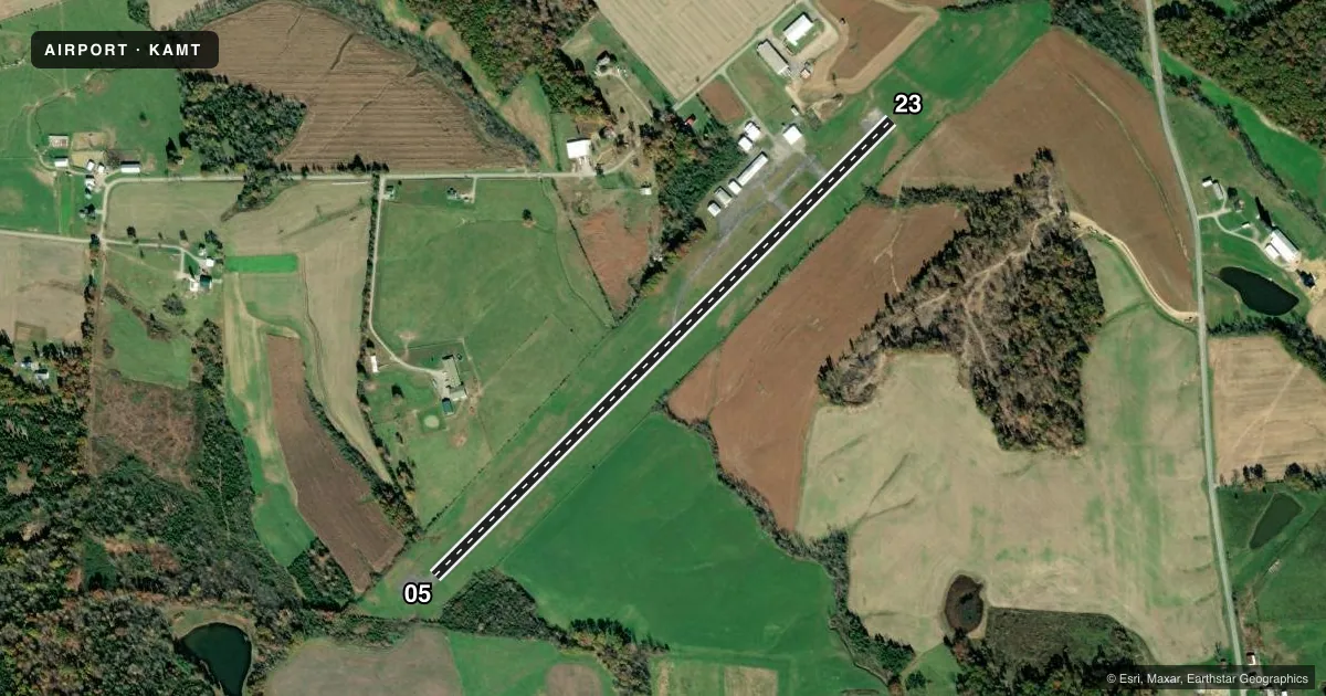
Airport sketch
Runways drawn to scale from FAA survey coordinates, rendered over satellite imagery. Not for navigation.
Approaches & charts
Services on the field
Fuel grades, oxygen, maintenance, ramp storage and lighting — as declared to the FAA by the airport operator.
Fuel & services
- Fuel
- Not available
- Oxygen (bottled)
- Not available
- Oxygen (bulk)
- Not available
- Airframe repair
- Not available
- Power plant repair
- Not available
Ramp & ground
- Transient storage
- Tie-down
- Landing fee
- No fee published
- Lighting schedule
- SEE RMK
- Beacon schedule
- SS-SR
- Beacon
- White / Green (civil land)(WG)
- Wind indicator
- Lighted
- Segmented circle
- No
Fuel & FBOs
Cheapest 100LL and Jet A on the field and nearby. Always confirm with the FBO before taxi.
Airport notes
Surface conditions, obstructions, local procedures, lighting outages and other notes published with each FAA cycle.
General notes
- TWY MKD WITH REFLECTORS.
- DEER, BIRDS, & OTR WILDLIFE ON & INVOF ARPT.
- FOR CD CTC INDIANAPOLIS ARTCC AT 317-247-2411.
Lighting notes
- ACTVT REIL RWY 05 & 23; PAPI RWY 23; MIRL RWY 05/23 - CTAF.
Approach & departure obstructions
- 05+5 FT FENCE, 0-200 FT DIST, 210 FT L/R; +32-34 FT BRUSH/TREES, 0-200 FT DIST, 215 FT L.
- 23+5 FT FENCE, 0-200 FT DIST, 200 FT L; +5-15 FT BRUSH, 0-200 FT DIST, 200 FT L.
- 05FADED.
- 23FADED.
- 05ALSO +239 FT HILL/TREES, 2650 FT DIST, 259 FT L, 10:1.
Other notes
- THIS AIRPORT HAS BEEN SURVEYED BY THE NATIONAL GEODETIC SURVEY.
- VFR ONLY.
VFR map & nearby airports
VFR sectional. Tap any ICAO chip to open that airport.
Key facts · KAMT
Answer card- ICAO
- KAMT
- Name
- ALEXANDER SALAMON
- Location
- WEST UNION, OHIO
- Elevation
- 896 ft MSL
- Traffic pattern altitude
- 1,896 ft MSL (1,000 AGL)
- Control tower
- Non-towered (use CTAF)
- Total runways
- 1
- Longest runway
- 05/23 · 3,558 ft
- Published ILS approaches
- 0
- Published frequencies
- 2
- Magnetic variation
- 4°
- Current flight rules
- MVFR
- Current wind
- 300° at 3 kt
- Favored runway now
- RWY 23
Alexander Salamon Airport sits in West Union, Ohio. Field elevation is 896 ft MSL. The airport has one runway. Runway 05/23 is 3,558 ft of asphalt, which is the longest runway on the field. There is no control tower. Use CTAF and UNICOM 122.8. No ILS approaches are published here. The published pattern altitude is not listed, so plan on the standard 1,000 ft AGL for light piston traffic unless the current FAA Chart Supplement says otherwise.
This is a VFR-only airport. Runway end identifier lights are active on both ends. Medium intensity runway lights are installed on 05 and 23. PAPI is installed on runway 23. Runway markings on both ends are faded, so treat the painted cues with care on rollout and lineup. The published remarks also call out wildlife on and near the airport. Expect deer and birds in the area.
There are no on-field FBOs listed in the facts. Contact the airport operator directly or call the field on CTAF or UNICOM for current service status before you go. The airport has reflector-marked taxiways. There are also published obstructions near both runway ends, including fences and brush. The 05 end also has a hill and trees on the extended centerline. That makes a stable approach and a careful departure profile important, especially in marginal VFR or at night.