METAR & TAF I69
Current METAR
Observed 22:56Z
KI69 242256Z AUTO 00000KT 10SM CLR 25/15 A3008 RMK AO1 T02450147
- Wind
- 000° @ 0 kt
- Visibility
- 10 SM
- Temp / Dew
- 25°C / 15°C
- Altimeter
- 30.08 inHg
- Clouds
- CLR
- Density alt
- 2,048 ft
- Ceiling
- Unlimited
- Rules
- VFR
Airport info & contacts
Manager on record, flight service, ARTCC, attendance schedule and pattern altitude — published by the FAA and refreshed every 28 days.
Location
- From city
- 2 NM W
- VFR sectional
- CINCINNATI
- ARTCC
- ZID · INDIANAPOLIS
- NOTAM facility
- I69 (NOTAM-D)
Airport manager
- Name
- CHUCK GALLAGHER
- Phone
- 513-735-9100
- Address
- 2001 SPORTYS DR, BATAVIA OH 45103-9719
Flight service · Hours
- FSS DAY
- DAYTON1-800-WX-BRIEF
- Attendance
- MON-THU · 0900-DUSK
- FRI-SAT · 0900-1700
- SUN · 1000-1700
Frequencies
Tap any row to copy the frequency to your clipboard.
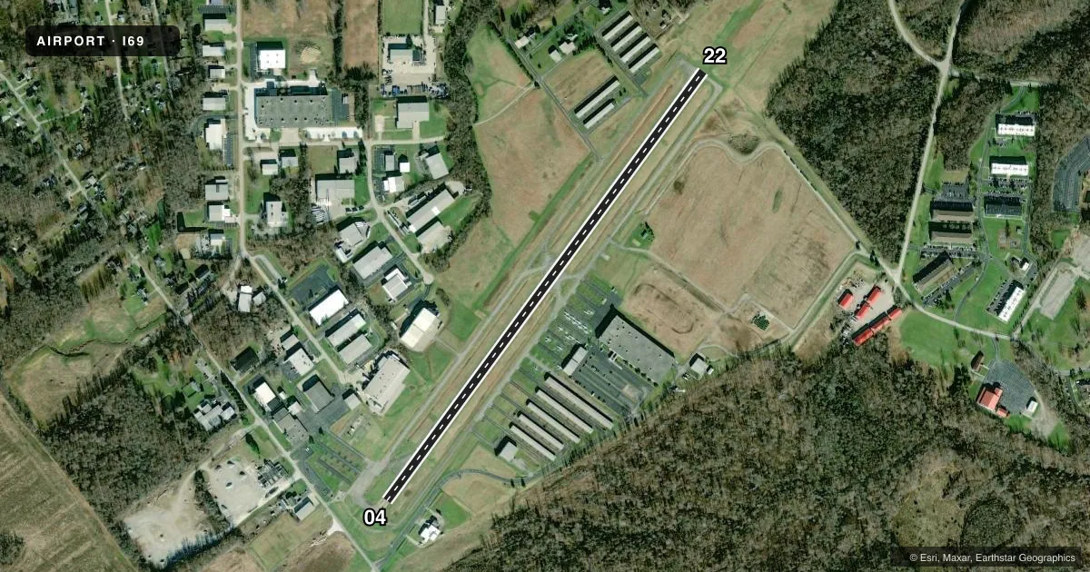
Runways & pattern
Full pagePattern entry · RWY 04
LEFT TRAFFICRunway end performance
| End | TORA | TODA | ASDA | LDA | VGSI | Approach lights | Obstruction |
|---|---|---|---|---|---|---|---|
| 04 | — | — | — | — | PAPI 2-box left(4°) | — | 12', road, 201' from thr, 225' R of cntrln, slope 0 |
| 22 | — | — | — | — | PAPI 2-box left(3°) | — | 75', trees, 1350' from thr, 410' R of cntrln, slope 15 |
Declared distances in feet. TORA = takeoff run available, TODA = takeoff distance, ASDA = accelerate-stop, LDA = landing distance.
Airport sketch
Runways drawn to scale from FAA survey coordinates, rendered over satellite imagery. Not for navigation.
Approaches & charts
Services on the field
Fuel grades, oxygen, maintenance, ramp storage and lighting — as declared to the FAA by the airport operator.
Fuel & services
- Fuel
- 100LLA
- Oxygen (bottled)
- Not available
- Oxygen (bulk)
- Not available
- Airframe repair
- Major
- Power plant repair
- Major
- Other services
- AVNCS,INSTR,RNTL,SALES
Ramp & ground
- Transient storage
- Tie-down
- Hangar
- Landing fee
- No fee published
- Customs
- Not available
- Lighting schedule
- SEE RMK
- Beacon schedule
- SS-SR
- Beacon
- White / Green (civil land)(WG)
- Wind indicator
- Yes
- Segmented circle
- No
Fuel & FBOs
Cheapest 100LL and Jet A on the field and nearby. Always confirm with the FBO before taxi.
Airport notes
Surface conditions, obstructions, local procedures, lighting outages and other notes published with each FAA cycle.
General notes
- TAXI ON HARD SFC ONLY.
- DEER, BIRDS, & OTR WILDLIFE ON & INVOF ARPT.
- FOR CD CTC CINCINNATI APCH AT 859-372-6440.
Lighting notes
- ACTVT REIL RWY 04 & 22; PAPI RWY 04 & 22; MIRL RWY 04/22 - CTAF.
Fuel notes
- AICING INHIBITOR AVBL BY INJECTION.
Approach & departure obstructions
- 04CLOSE-IN OBSTNS INCL FENCES & ROADS.
- 22CLOSE-IN OBSTNS INCL CONC PIPE & FENCE.
- 040:1 APCH SLP TO DTHR OVR 12 FT ROAD, 225 FT R.
Other notes
- PRIOR CDN RQRD FOR TSNT HNGR.
- PRIOR CDN RQRD FOR TSNT TIEDOWN.
- MANAGEREXTN 227.
VFR map & nearby airports
VFR sectional. Tap any ICAO chip to open that airport.
Key facts · I69
Answer card- ICAO
- I69
- Name
- CLERMONT COUNTY
- Location
- BATAVIA, OHIO
- Elevation
- 843.5 ft MSL
- Traffic pattern altitude
- 1,843.5 ft MSL (1,000 AGL)
- Control tower
- Non-towered (use CTAF)
- Total runways
- 1
- Longest runway
- 04/22 · 3,567 ft
- Published ILS approaches
- 0
- Published frequencies
- 5
- Magnetic variation
- 4°
- Current flight rules
- VFR
- Current wind
- 000° at 0 kt
- Favored runway now
- –
Clermont County Airport (I69) sits in Batavia, Ohio. The field elevation is 843.5 ft MSL. It has one runway, 04/22, which is 3,567 ft long and asphalt. There is no control tower. Pattern altitude is not published, so use the standard 1,000 ft AGL for light piston operations unless current published guidance says otherwise. No ILS approaches are published here.
Eastern Cincinnati Aviation is on the field. It carries 100LL, Jet A and Jet A Prist. Icing inhibitor is available by injection. Prior coordination is required for transient tiedown and transient hangar. Taxi on hard surface only. Deer, birds and other wildlife are reported on and near the airport. Keep a sharp scan on taxi, takeoff and landing.
Runway lighting is pilot controlled on CTAF. Runway end identifier lights and PAPI are installed on 04 and 22. There are close-in obstructions near both runway ends. Fences and roads are near runway 04. A concrete pipe and fence are near runway 22. There is also a road 225 ft right of runway 04 with a zero to one approach slope to the displaced threshold. For clearance delivery, contact Cincinnati Approach. This is a non-towered field with Cincinnati area traffic. Expect to self-announce and stay ahead of the pattern.