METAR & TAF KHAO
Current METAR
Observed 06:22Z
KHAO 270622Z AUTO 00000KT 1/2SM FG CLR 18/18 A2993 RMK AO2 T01830178
- Wind
- 000° @ 0 kt
- Visibility
- 0.5 SM
- Temp / Dew
- 18°C / 18°C
- Altimeter
- 29.93 inHg
- Clouds
- CLR
- Density alt
- 1,131 ft
- Ceiling
- Unlimited
- Rules
- LIFR
Airport info & contacts
Manager on record, flight service, ARTCC, attendance schedule and pattern altitude — published by the FAA and refreshed every 28 days.
Location
- From city
- 3 NM SE
- VFR sectional
- CINCINNATI
- ARTCC
- ZID · INDIANAPOLIS
- NOTAM facility
- HAO (NOTAM-D)
Airport manager
- Name
- JERRY RICHARDSON
- Phone
- 513-785-5444
- Address
- 7802 E AIRPORT RD, HAMILTON OH 45015
Flight service · Hours
- FSS DAY
- DAYTON1-800-WX-BRIEF
- Attendance
- NOV-MAR · 0700-2100
- APR-OCT · 0700-2200
Frequencies
Tap any row to copy the frequency to your clipboard.
Runways & pattern
Full pagePattern entry · RWY 12
LEFT TRAFFICRunway end performance
| End | TORA | TODA | ASDA | LDA | VGSI | Approach lights | Obstruction |
|---|---|---|---|---|---|---|---|
| 12 | — | — | — | — | PAPI 4-box left(3.5°) | — | 137', trees, 2520' from thr, 537' R of cntrln, slope 16 |
| 30 | — | — | — | — | PAPI 4-box left(3°) | MALS | 25', trees, 382' from thr, 434' R of cntrln, slope 7 |
Declared distances in feet. TORA = takeoff run available, TODA = takeoff distance, ASDA = accelerate-stop, LDA = landing distance.
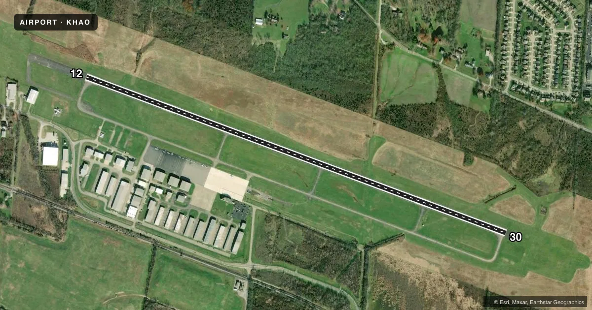
Airport sketch
Runways drawn to scale from FAA survey coordinates, rendered over satellite imagery. Not for navigation.
Approaches & charts
ILS · 1
Services on the field
Fuel grades, oxygen, maintenance, ramp storage and lighting — as declared to the FAA by the airport operator.
Fuel & services
- Fuel
- 100LLAA+
- Oxygen (bottled)
- Low pressure
- Oxygen (bulk)
- Not available
- Airframe repair
- Major
- Power plant repair
- Major
- Other services
- AMB,CHTR,INSTR,RNTL
Ramp & ground
- Transient storage
- Tie-down
- Hangar
- Landing fee
- No fee published
- Customs
- Not available
- Lighting schedule
- SEE RMK
- Beacon schedule
- SS-SR
- Beacon
- White / Green (civil land)(WG)
- Wind indicator
- Lighted
- Segmented circle
- No
Fuel & FBOs
Cheapest 100LL and Jet A on the field and nearby. Always confirm with the FBO before taxi.
Airport notes
Surface conditions, obstructions, local procedures, lighting outages and other notes published with each FAA cycle.
General notes
- FOR CD CTC CINCINNATI APCH AT 859-372-6440.
- DEER, BIRDS, & OTR WILDLIFE ON & INVOF ARPT.
Lighting notes
- ACTVT MALS RWY 30; REIL RWY 12 & 30; PAPI RWY 12 & 30; MIRL RWY 12/30 - CTAF.
Fuel notes
- A+JET A+ AVBL ON REQ AT DLVY.
Approach & departure obstructions
- 12+3-9 FT BRUSH, 0-200 FT DIST, 190-415 FT L.
- 12ALSO 29:1 OVR +60 FT TREE, 1993 DIST, 351 FT R.
Other notes
- THIS AIRPORT HAS BEEN SURVEYED BY THE NATIONAL GEODETIC SURVEY.
- PRIOR CDN RQRD FOR TSNT HNGR - CALL FBO.
VFR map & nearby airports
VFR sectional. Tap any ICAO chip to open that airport.
Key facts · KHAO
Answer card- ICAO
- KHAO
- Name
- BUTLER COUNTY RGNL/HOGAN FLD
- Location
- HAMILTON, OHIO
- Elevation
- 631.8 ft MSL
- Traffic pattern altitude
- 1,631.8 ft MSL (1,000 AGL)
- Control tower
- Non-towered (use CTAF)
- Total runways
- 1
- Longest runway
- 12/30 · 5,500 ft
- Published ILS approaches
- 1
- Published frequencies
- 5
- Magnetic variation
- 6°
- Current flight rules
- LIFR
- Current wind
- 000° at 0 kt
- Favored runway now
- –
Butler County Rgnl/Hogan Fld sits in Hamilton, Ohio. Field elevation is 631.8 ft MSL. The airport has one runway, 12/30, which is 5,500 ft of asphalt. There is no control tower. Pattern altitude is not published, so use the standard 1,000 ft AGL for light piston traffic unless the current Chart Supplement says otherwise. That puts the pattern at about 1,632 ft MSL.
Runway 30 has an ILS. The field also has medium intensity runway lights, runway end identifier lights on both ends and PAPI on runways 12 and 30. The published remarks call out wildlife in the area. They also note obstructions near runway 12, including brush close to the departure end and a 60-foot tree off the right side. That makes a careful runway 12 departure worth planning.
Cincinnati Jet Center is on the field. It carries 100LL, Jet A and Jet A Prist. Prior coordination is required for transient hangar use. For clearance delivery, contact Cincinnati Approach at 859-372-6440. Use CTAF 123.05 for local traffic. This is a non-towered field. Keep your scan tight. Expect standard self-announce procedures.