METAR & TAF KMWO
Current METAR
Observed 12:55Z
KMWO 271255Z AUTO 00000KT 5SM BR CLR 21/21 A2996 RMK AO2
- Wind
- 000° @ 0 kt
- Visibility
- 5 SM
- Temp / Dew
- 21°C / 21°C
- Altimeter
- 29.96 inHg
- Clouds
- CLR
- Density alt
- 1,477 ft
- Ceiling
- Unlimited
- Rules
- MVFR
Airport info & contacts
Manager on record, flight service, ARTCC, attendance schedule and pattern altitude — published by the FAA and refreshed every 28 days.
Location
- From city
- 2 NM N
- VFR sectional
- CINCINNATI
- ARTCC
- ZID · INDIANAPOLIS
- NOTAM facility
- MWO (NOTAM-D)
Airport manager
- Name
- NIKOLAS BRUMBACK
- Phone
- 513-705-1777
- Address
- 1 DONHAM PLZ, MIDDLETOWN OH 45042-1932
Flight service · Hours
- FSS DAY
- DAYTON1-800-WX-BRIEF
- Attendance
- 0700-1900
Frequencies
Tap any row to copy the frequency to your clipboard.
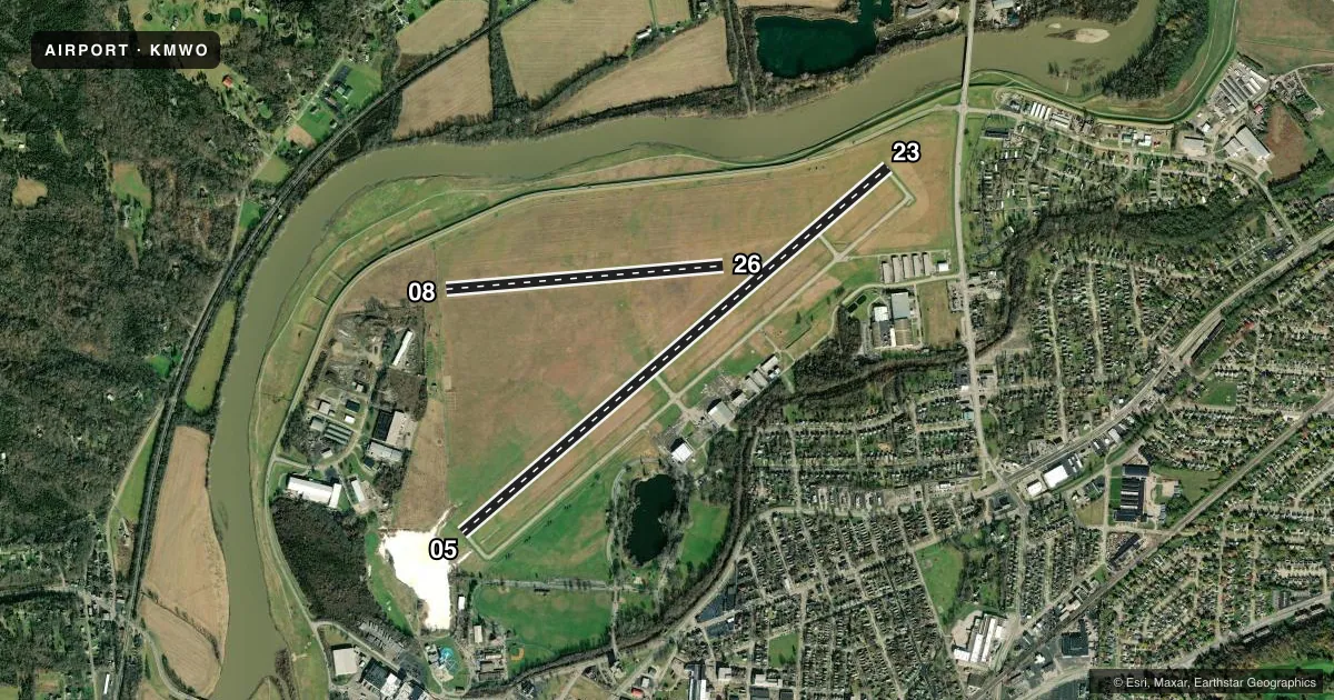
Runways & pattern
Full pagePattern entry · RWY 05
LEFT TRAFFIC| Runway | Heading (°M) | Length | Surface | Traffic |
|---|---|---|---|---|
| 05/23 | 45° / 225° | 6,100 ft | ASPH | 23 R |
| 08/26 | 81° / 261° | 3,026 ft | TURF | 26 R |
Runway end performance
| End | TORA | TODA | ASDA | LDA | VGSI | Approach lights | Obstruction |
|---|---|---|---|---|---|---|---|
| 05 | — | — | — | — | PAPI 4-box left(3°) | — | 30', trees, 771' from thr, 236' R of cntrln, slope 19 |
| 23 | — | — | — | — | PAPI 4-box left(3°) | — | 40', tree, 885' from thr, 300' R of cntrln, slope 17 |
| 08 | — | — | — | — | — | — | 95', trees, 771' from thr, 170' R of cntrln, slope 8 |
Declared distances in feet. TORA = takeoff run available, TODA = takeoff distance, ASDA = accelerate-stop, LDA = landing distance.
Airport sketch
Runways drawn to scale from FAA survey coordinates, rendered over satellite imagery. Not for navigation.
Approaches & charts
ILS · 1
Services on the field
Fuel grades, oxygen, maintenance, ramp storage and lighting — as declared to the FAA by the airport operator.
Fuel & services
- Fuel
- 100LLA+
- Oxygen (bottled)
- Low pressure
- Oxygen (bulk)
- Not available
- Airframe repair
- Major
- Power plant repair
- Major
- Other services
- CARGO,INSTR,PAJA,RNTL
Ramp & ground
- Transient storage
- Tie-down
- Hangar
- Landing fee
- No fee published
- Customs
- Not available
- Lighting schedule
- SEE RMK
- Beacon schedule
- SS-SR
- Beacon
- White / Green (civil land)(WG)
- Wind indicator
- Lighted
- Segmented circle
- No
Fuel & FBOs
Cheapest 100LL and Jet A on the field and nearby. Always confirm with the FBO before taxi.
Airport notes
Surface conditions, obstructions, local procedures, lighting outages and other notes published with each FAA cycle.
General notes
- FOR CD CTC COLUMBUS APCH AT 614-338-8537.
- EXTSV PAJA.
- DEER, BIRDS, & OTR WILDLIFE ON & INVOF ARPT.
- ULTRALIGHTS ENTER/EXIT RWY 08 TFC PAT FM/TO THE NORTH AT LWR THAN RGLR TPA. ULTRALIGHTS DO NOT FLY SOUTH OF RWY 26.
Lighting notes
- ACTVT REIL RWY 05 & 23; MIRL RWY 05/23 - CTAF. PAPI RWY 05 & 23 OPR CONSLY.
Fuel notes
- A+FOR FUEL AFT HRS CALL 513-425-7845.
Approach & departure obstructions
- 08WHITE CONES.
- 26WHITE CONES.
- 08OBSTN CLNC SLP 18:1 TO DTHR.
- 23OBSTN CLNC SLP 33:1 TO DTHR.
Other notes
- PRIOR CDN RQRD FOR TSNT HNGR.
- MANAGERINFO@FLYMWO.COM.
- MANAGERCELL 513-236-3238.
VFR map & nearby airports
VFR sectional. Tap any ICAO chip to open that airport.
Key facts · KMWO
Answer card- ICAO
- KMWO
- Name
- MIDDLETOWN RGNL/HOOK FLD
- Location
- MIDDLETOWN, OHIO
- Elevation
- 650.6 ft MSL
- Traffic pattern altitude
- 1,650.6 ft MSL (1,000 AGL)
- Control tower
- Non-towered (use CTAF)
- Total runways
- 2
- Longest runway
- 05/23 · 6,100 ft
- Published ILS approaches
- 1
- Published frequencies
- 4
- Magnetic variation
- 4°
- Current flight rules
- MVFR
- Current wind
- 000° at 0 kt
- Favored runway now
- –
Middletown Rgnl/Hook Fld sits in Middletown, Ohio. Field elevation is 650.6 ft MSL. The airport has two runways. The longest is runway 05/23 at 6,100 ft. Runway 08/26 is turf and is 3,026 ft. There is no control tower. Use CTAF 123.0 for local traffic. The published approach support includes one ILS to runway 23. Pattern altitude is not published. Use the standard 1,000 ft AGL for light piston traffic unless the Chart Supplement says otherwise.
Middletown FBO Services is on the field. It carries 100LL and Jet A. For clearance delivery, Columbus Approach is listed in the remarks. The field also has extensive pilot-activated lighting. Runway 05 and runway 23 have medium intensity lights. Runway end identifier lights are also published for those ends. The PAPI on 05 and 23 operates continuously. Runway 08 and runway 26 use white cones as runway end markings. The remarks also call out wildlife on and near the airport. Keep a sharp scan on taxi, takeoff and landing. Ultralights use the runway 08 pattern from the north at lower than regular pattern altitude. They do not fly south of runway 26. If you need transient hangar space, coordinate ahead of time.