METAR & TAF I44
I44 does not publish a METAR.
Showing the nearest reporting station: KDAY (JAMES M COX DAYTON INTL) · 10.0 NM away. Conditions at I44 may differ.
METAR · KDAY
Observed 14:56Z
KDAY 271456Z 29005KT 10SM SCT200 BKN240 26/22 A2996 RMK AO2 SLP136 T02560217 53001
- Wind
- 290° @ 5 kt
- Visibility
- 10 SM
- Temp / Dew
- 26°C / 22°C
- Altimeter
- 29.96 inHg
- Clouds
- BKN
- Density alt
- 2,417 ft
- Ceiling
- 24,000 ft AGL
- Rules
- VFR
Airport info & contacts
Manager on record, flight service, ARTCC, attendance schedule and pattern altitude — published by the FAA and refreshed every 28 days.
Location
- From city
- 7 NM W
- VFR sectional
- CINCINNATI
- ARTCC
- ZID · INDIANAPOLIS
- NOTAM facility
- DAY (NOTAM-D)
Airport manager
- Name
- STEVE RAUCH
- Phone
- 937-604-2619
- Address
- 1550 SOLDIERS HOME-WEST CARROLLTON, DAYTON OH 45417-6146
Flight service · Hours
- FSS DAY
- DAYTON1-800-WX-BRIEF
- Attendance
- Unattended
Frequencies
Tap any row to copy the frequency to your clipboard.
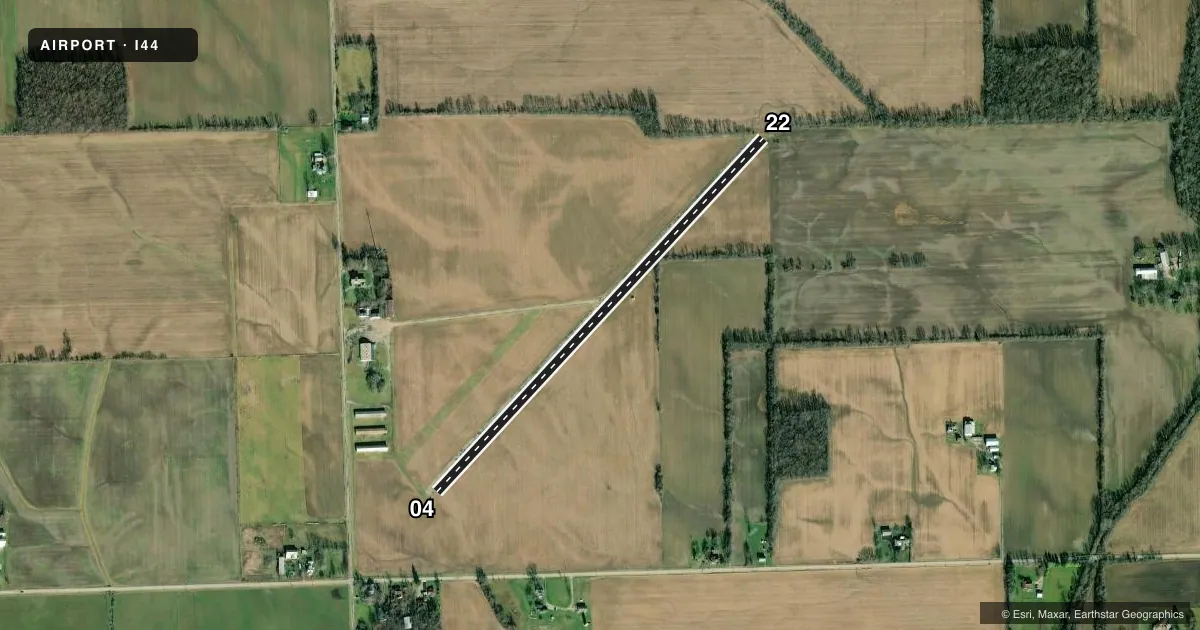
Runways & pattern
Full pagePattern entry · RWY 22
LEFT TRAFFICRunway end performance
| End | TORA | TODA | ASDA | LDA | VGSI | Approach lights | Obstruction |
|---|---|---|---|---|---|---|---|
| 04 | — | — | — | — | — | — | 77', trees, 700' from thr, 109' R of cntrln, slope 6 |
| 22 | — | — | — | — | — | — | 40', trees, 201' from thr, 90' R of cntrln, slope 1 |
Declared distances in feet. TORA = takeoff run available, TODA = takeoff distance, ASDA = accelerate-stop, LDA = landing distance.
Airport sketch
Runways drawn to scale from FAA survey coordinates, rendered over satellite imagery. Not for navigation.
Approaches & charts
Services on the field
Fuel grades, oxygen, maintenance, ramp storage and lighting — as declared to the FAA by the airport operator.
Fuel & services
- Fuel
- Not available
- Oxygen (bottled)
- Not available
- Oxygen (bulk)
- Not available
- Airframe repair
- Not available
- Power plant repair
- Not available
Ramp & ground
- Transient storage
- Not published
- Landing fee
- No fee published
- Customs
- Not available
- Wind indicator
- Yes
- Segmented circle
- No
Fuel & FBOs
Cheapest 100LL and Jet A on the field and nearby. Always confirm with the FBO before taxi.
Airport notes
Surface conditions, obstructions, local procedures, lighting outages and other notes published with each FAA cycle.
General notes
- ULTRALIGHTS & PWRD PRCHTS ON & INVOF ARPT.
- FOR CD CTC COLUMBUS APCH AT 614-338-8537.
- MOWED PATH FM RWY 04 END TO HNGR AREA NOT SUITABLE FOR ACFT.
- TWY FM MIDFIELD TO HNGR AREA IN POOR COND - EXTSV VEGETATION & FOD.
- SEASONAL CROPS ALG ENTR LEN RWY 04/22, 10 FT FM RWY EDGE, BOTH SIDES.
Runway surface & condition
- 04/225000 LBS PER AMGR.
Approach & departure obstructions
- 22+10-20 FT BRUSH/TREES, 25 FT DIST, 20-125 FT L; +10-25 FT BRUSH/TREES, 0 FT DIST, 20-125 FT R.
Other notes
- 04/22NMRS CRACKS IN PAVEMENT WITH 3 FT VEGETATION & EXTSV FOD.
VFR map & nearby airports
VFR sectional. Tap any ICAO chip to open that airport.
Key facts · I44
Answer card- ICAO
- I44
- Name
- DAHIO TROTWOOD
- Location
- DAYTON, OHIO
- Elevation
- 925 ft MSL
- Traffic pattern altitude
- 1,925 ft MSL (1,000 AGL)
- Control tower
- Non-towered (use CTAF)
- Total runways
- 1
- Longest runway
- 04/22 · 2,900 ft
- Published ILS approaches
- 0
- Published frequencies
- 4
- Magnetic variation
- –
- Current flight rules
- VFR
- Current wind
- 290° at 5 kt
- Favored runway now
- RWY 22
DAHIO TROTWOOD (I44) sits in Dayton, Ohio at 925 ft MSL. It has one runway. Runway 04/22 is 2,900 ft long and asphalt. There is no control tower. No ILS approaches are published. The pattern altitude is not published, so verify the current traffic pattern in the FAA Chart Supplement before you go. For light piston traffic, a standard 1,000 ft AGL pattern is often used when no published value exists. Confirm local practice before arrival.
There are no on-field FBOs listed in the facts. Call the airport operator or the field directly for current services before departure. Published remarks matter here. Runway 22 has brush and trees near the departure end. Seasonal crops run along the full length of runway 04/22. The pavement has numerous cracks with vegetation and foreign object debris. The taxiway from midfield to the hangar area is also in poor condition. Ultralights and powered parachutes operate on and near the airport. Keep a sharp lookout in the pattern and on the ground.
Clearance delivery is handled through Columbus Approach at 614-338-8537. The field also has no published tower hours because it is non-towered. Check the current FAA Chart Supplement for any noise or curfew restrictions before flying in. This is a field where a careful preflight, a short field plan and a good scan for debris matter.