METAR & TAF KGDK
Current METAR
Observed 05:15Z
KGDK 270515Z AUTO 00000KT 10SM OVC070 21/21 A2991 RMK AO2
- Wind
- 000° @ 0 kt
- Visibility
- 10 SM
- Temp / Dew
- 21°C / 21°C
- Altimeter
- 29.91 inHg
- Clouds
- OVC
- Density alt
- 1,909 ft
- Ceiling
- 7,000 ft AGL
- Rules
- VFR
Airport info & contacts
Manager on record, flight service, ARTCC, attendance schedule and pattern altitude — published by the FAA and refreshed every 28 days.
Location
- From city
- 10 NM E
- VFR sectional
- CINCINNATI
- ARTCC
- ZID · INDIANAPOLIS
- NOTAM facility
- GDK (NOTAM-D)
Airport manager
- Name
- ALEXANDREA BARRETT
- Phone
- 937-376-8107
- Address
- 140 N VALLEY RD, XENIA OH 45385-9301
Flight service · Hours
- FSS DAY
- DAYTON1-800-WX-BRIEF
- Attendance
- APR-OCT · 0800-2000
- NOV-MAR · 0800-1800
Frequencies
Tap any row to copy the frequency to your clipboard.
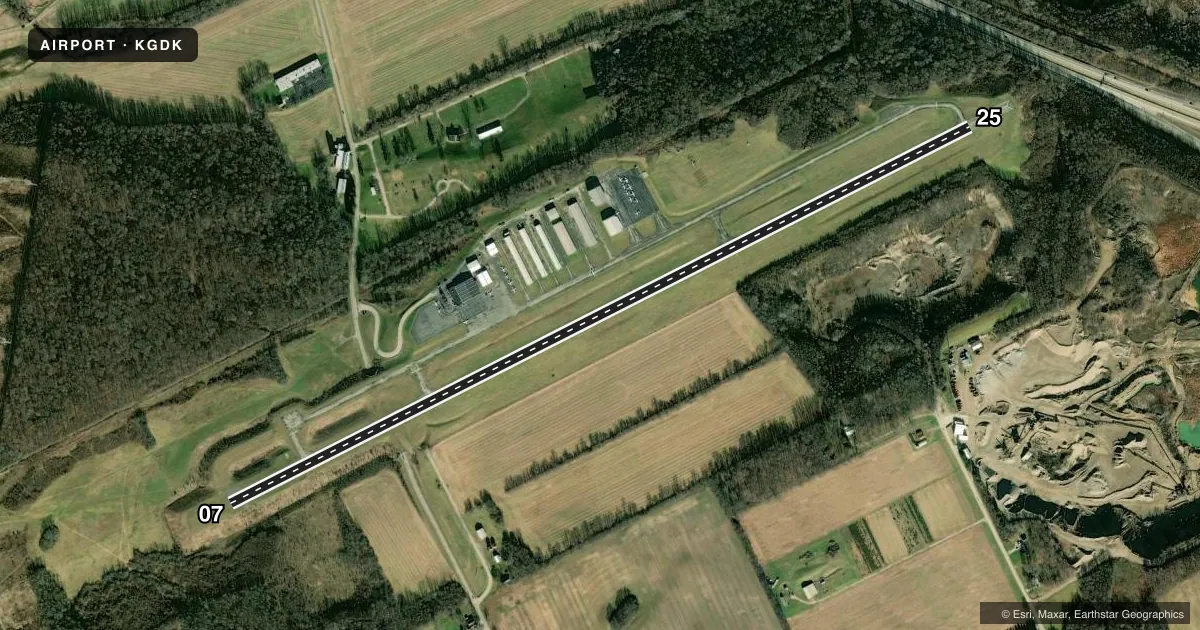
Runways & pattern
Full pagePattern entry · RWY 07
LEFT TRAFFICRunway end performance
| End | TORA | TODA | ASDA | LDA | VGSI | Approach lights | Obstruction |
|---|---|---|---|---|---|---|---|
| 07 | — | — | — | — | PAPI 2-box left(3.5°) | — | — |
| 25 | — | — | — | — | PAPI 2-box left(3.5°) | — | — |
Declared distances in feet. TORA = takeoff run available, TODA = takeoff distance, ASDA = accelerate-stop, LDA = landing distance.
Airport sketch
Runways drawn to scale from FAA survey coordinates, rendered over satellite imagery. Not for navigation.
Approaches & charts
Services on the field
Fuel grades, oxygen, maintenance, ramp storage and lighting — as declared to the FAA by the airport operator.
Fuel & services
- Fuel
- 100LLA
- Oxygen (bottled)
- Not available
- Oxygen (bulk)
- High pressure
- Airframe repair
- Major
- Power plant repair
- Major
- Other services
- INSTR,RNTL
Ramp & ground
- Transient storage
- Tie-down
- Hangar
- Landing fee
- No fee published
- Customs
- Not available
- Lighting schedule
- SEE RMK
- Beacon schedule
- SS-SR
- Beacon
- White / Green (civil land)(WG)
- Wind indicator
- Lighted
- Segmented circle
- No
Fuel & FBOs
Cheapest 100LL and Jet A on the field and nearby. Always confirm with the FBO before taxi.
Airport notes
Surface conditions, obstructions, local procedures, lighting outages and other notes published with each FAA cycle.
General notes
- DEER, BIRDS, & OTR WILDLIFE ON & INVOF ARPT.
- FOR CD CTC COLUMBUS APCH AT 614-338-8537.
- EXTSV FLT TRG ACT.
Lighting notes
- ACTVT REIL RWY 07 & 25; MIRL RWY 07/25 - CTAF. PAPI RWY 07 & 25 OPR CONSLY.
Fuel notes
- 100LL100LL & JET A AVBL H24 SELF SVC VIA CREDIT CARD.
- AANTI-ICING AVBL AT NOZZLE.
Approach & departure obstructions
- 075-10 FT BRUSH, 0-150 FT DIST, 150 FT L; 5-10 FT BRUSH, 0-50 FT DIST, 230 FT R.
Other notes
- PRIOR CDN RQRD FOR TSNT HNGR.
- 2UNATNDD THANKSGIVING, CHRISTMAS, & NEW YEARS DAY.
VFR map & nearby airports
VFR sectional. Tap any ICAO chip to open that airport.
Key facts · KGDK
Answer card- ICAO
- KGDK
- Name
- GREENE COUNTY/LEWIS A JACKSON RGNL
- Location
- DAYTON, OHIO
- Elevation
- 948.5 ft MSL
- Traffic pattern altitude
- 1,948.5 ft MSL (1,000 AGL)
- Control tower
- Non-towered (use CTAF)
- Total runways
- 1
- Longest runway
- 07/25 · 5,004 ft
- Published ILS approaches
- 0
- Published frequencies
- 4
- Magnetic variation
- 5°
- Current flight rules
- VFR
- Current wind
- 000° at 0 kt
- Favored runway now
- –
Greene County/Lewis A Jackson Rgnl (KGDK) sits in Dayton, Ohio at 948.5 ft MSL. It has one runway. Runway 07/25 is 5,004 ft long, so it is the runway to plan around here. There is no control tower. Pattern altitude is not published, so use 1,000 ft AGL for light piston operations unless the current Chart Supplement says otherwise.
No ILS approaches are published at KGDK. For clearance delivery, Columbus Approach is listed in the remarks. The field has a lot of flight training activity, so expect busy pattern work. Expect frequent radio traffic. Runway 07 and 25 have active runway end identifier lights. Medium intensity runway lights are pilot controlled on CTAF. The PAPI on both ends operates continuously.
MacAir Aviation is on the field. It carries 100LL, Jet A and Jet A Prist. 100LL and Jet A are available 24 hours a day self-serve by credit card. Anti-icing is available at the nozzle. There is also a note that transient hangar use needs prior coordination. Watch for deer, birds and other wildlife in the area. There is brush near runway 07, so pay attention on that end during takeoff and landing.