METAR & TAF I66
I66 does not publish a METAR.
Showing the nearest reporting station: KILN (WILMINGTON AIR PARK) · 5.6 NM away. Conditions at I66 may differ.
METAR · KILN
Observed 12:54Z
KILN 271254Z AUTO 29004KT 6SM BR CLR 22/21 A2996 RMK AO2 SLP137 T02170206
- Wind
- 290° @ 4 kt
- Visibility
- 6 SM
- Temp / Dew
- 22°C / 21°C
- Altimeter
- 29.96 inHg
- Clouds
- CLR
- Density alt
- 2,071 ft
- Ceiling
- Unlimited
- Rules
- VFR
Airport info & contacts
Manager on record, flight service, ARTCC, attendance schedule and pattern altitude — published by the FAA and refreshed every 28 days.
Location
- From city
- 4 NM NW
- VFR sectional
- CINCINNATI
- ARTCC
- ZID · INDIANAPOLIS
- NOTAM facility
- DAY (NOTAM-D)
Airport manager
- Name
- MELODY WALDMANN
- Phone
- 937-382-4638
- Address
- 1581 N CURRY RD, WILMINGTON OH 45177-9048
Flight service · Hours
- FSS DAY
- DAYTON1-800-WX-BRIEF
- Attendance
- Unattended
Frequencies
Tap any row to copy the frequency to your clipboard.
Runways & pattern
Full pagePattern entry · RWY 21
LEFT TRAFFICRunway end performance
| End | TORA | TODA | ASDA | LDA | VGSI | Approach lights | Obstruction |
|---|---|---|---|---|---|---|---|
| 03 | — | — | — | — | PAPI 2-box left(3°) | — | 55', trees, 460' from thr, 256' R of cntrln, slope 4 |
| 21 | — | — | — | — | PAPI 2-box left(3.75°) | — | 30', tree, 281' from thr, 250' R of cntrln, slope 2 |
Declared distances in feet. TORA = takeoff run available, TODA = takeoff distance, ASDA = accelerate-stop, LDA = landing distance.
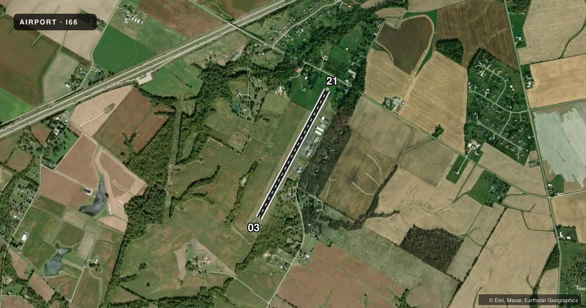
Airport sketch
Runways drawn to scale from FAA survey coordinates, rendered over satellite imagery. Not for navigation.
Approaches & charts
Services on the field
Fuel grades, oxygen, maintenance, ramp storage and lighting — as declared to the FAA by the airport operator.
Fuel & services
- Fuel
- 100LL
- Oxygen (bottled)
- Not available
- Oxygen (bulk)
- Not available
- Airframe repair
- Not available
- Power plant repair
- Not available
- Other services
- INSTR,RNTL
Ramp & ground
- Transient storage
- Tie-down
- Hangar
- Landing fee
- No fee published
- Customs
- Not available
- Lighting schedule
- SEE RMK
- Beacon schedule
- SS-SR
- Beacon
- White / Green (civil land)(WG)
- Wind indicator
- Lighted
- Segmented circle
- No
Fuel & FBOs
Cheapest 100LL and Jet A on the field and nearby. Always confirm with the FBO before taxi.
Airport notes
Surface conditions, obstructions, local procedures, lighting outages and other notes published with each FAA cycle.
General notes
- DEER & BIRDS ON & INVOF ARPT.
- FOR CD CTC COLUMBUS APCH AT 614-338-8537.
Lighting notes
- ACTVT MIRL RWY 03/21 - CTAF. PAPI RWY 03 & 21 OPR CONSLY.
Fuel notes
- 100LLAVBL SELF SVC VIA CREDIT CARD ONLY.
Approach & departure obstructions
- 21+70 FT TREE, 94 FT DIST, 220 FT L.
Other notes
- FOR AVBLTY CALL 937-382-2889.
- ROPES NOT PRVDD.
- MANAGERCLINTONCOUNTYAIRPORT@YAHOO.COM.
- MANAGERCELL 937-725-1946.
VFR map & nearby airports
VFR sectional. Tap any ICAO chip to open that airport.
Key facts · I66
Answer card- ICAO
- I66
- Name
- CLINTON FLD
- Location
- WILMINGTON, OHIO
- Elevation
- 1,033.1 ft MSL
- Traffic pattern altitude
- 2,033.1 ft MSL (1,000 AGL)
- Control tower
- Non-towered (use CTAF)
- Total runways
- 1
- Longest runway
- 03/21 · 3,579 ft
- Published ILS approaches
- 0
- Published frequencies
- 4
- Magnetic variation
- 5°
- Current flight rules
- VFR
- Current wind
- 290° at 4 kt
- Favored runway now
- RWY 21
Clinton Fld sits in Wilmington, Ohio. The field elevation is 1,033.1 ft MSL. It has one runway, 03/21, which is 3,579 ft long. There is no control tower. Pattern altitude is not published, so use the standard 1,000 ft AGL for light piston traffic unless the current Chart Supplement says otherwise.
No ILS approaches are published here. Runway 03/21 has medium intensity lights that you activate by CTAF. The PAPI on both ends runs continuously. Great Plain Enterprises is on the field. It carries 100LL. Self-serve fuel is available by credit card only. Call ahead at (937) 382-2889 if you need current availability.
A first-time arrival should pay attention to the published obstacle near runway 21. There is also deer and bird activity on and near the airport. For clearance delivery, contact Columbus Approach at 614-338-8537. CTAF and UNICOM are both 122.725. If you need current noise, traffic flow, or any airport-specific operating detail, check the current FAA Chart Supplement or call the airport operator directly before you launch.