METAR & TAF I73
I73 does not publish a METAR.
Showing the nearest reporting station: KMGY (DAYTON/WRIGHT BROTHERS) · 5.6 NM away. Conditions at I73 may differ.
METAR · KMGY
Observed 14:53Z
KMGY 271453Z AUTO 00000KT 10SM FEW002 26/22 A2995 RMK AO2 SLP134 T02560217 53003
- Wind
- 000° @ 0 kt
- Visibility
- 10 SM
- Temp / Dew
- 26°C / 22°C
- Altimeter
- 29.95 inHg
- Clouds
- FEW
- Density alt
- 2,176 ft
- Ceiling
- Unlimited
- Rules
- VFR
Airport info & contacts
Manager on record, flight service, ARTCC, attendance schedule and pattern altitude — published by the FAA and refreshed every 28 days.
Location
- From city
- 4 NM SW
- VFR sectional
- CINCINNATI
- ARTCC
- ZID · INDIANAPOLIS
- NOTAM facility
- DAY (NOTAM-D)
Airport manager
- Name
- J R SNYDER
- Phone
- 937-866-2489
- Address
- 3800 CLEARVIEW AVE, MORAINE OH 45439-1199
Flight service · Hours
- FSS DAY
- DAYTON1-800-WX-BRIEF
- Attendance
- DALGT
Frequencies
Tap any row to copy the frequency to your clipboard.
Runways & pattern
Full pagePattern entry · RWY 08
LEFT TRAFFICRunway end performance
| End | TORA | TODA | ASDA | LDA | VGSI | Approach lights | Obstruction |
|---|---|---|---|---|---|---|---|
| 08 | — | — | — | — | — | — | 15', berm, 201' from thr, 75' R of cntrln, slope 1 |
| 26 | — | — | — | — | — | — | 6', berm, 201' from thr, 60' R of cntrln, slope 1 |
Declared distances in feet. TORA = takeoff run available, TODA = takeoff distance, ASDA = accelerate-stop, LDA = landing distance.
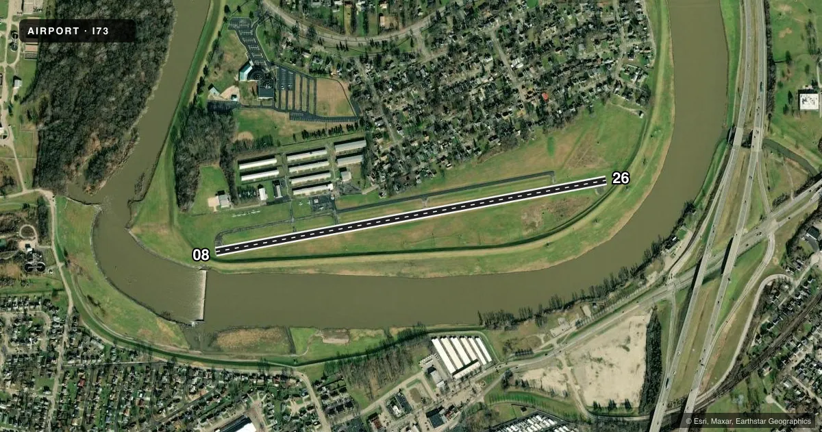
Airport sketch
Runways drawn to scale from FAA survey coordinates, rendered over satellite imagery. Not for navigation.
Approaches & charts
Services on the field
Fuel grades, oxygen, maintenance, ramp storage and lighting — as declared to the FAA by the airport operator.
Fuel & services
- Fuel
- 100LL
- Oxygen (bottled)
- Not available
- Oxygen (bulk)
- Not available
- Airframe repair
- Not available
- Power plant repair
- Not available
- Other services
- INSTR,RNTL
Ramp & ground
- Transient storage
- Tie-down
- Landing fee
- No fee published
- Customs
- Not available
- Lighting schedule
- SEE RMK
- Beacon schedule
- SS-SR
- Beacon
- White / Green (civil land)(WG)
- Wind indicator
- Yes
- Segmented circle
- No
Fuel & FBOs
Cheapest 100LL and Jet A on the field and nearby. Always confirm with the FBO before taxi.
Airport notes
Surface conditions, obstructions, local procedures, lighting outages and other notes published with each FAA cycle.
General notes
- 15 FT LEVEE SOUTH OF & PARL TO RWY. TREES NORTH OF RWY.
- PAEW ADJ TWYS.
- FOR CD CTC COLUMBUS APCH AT 614-338-8537.
- ULTRA-LIGHT ACTVTY.
- +75 FT TREE OVERHANGS PARL TWY BTN TRML & RWY END 26.
- MIL JETS OVR ARPT INBD & OUBD TO/FM KFFO AFB 12 NM NE.
- BIRDS INVOF ARPT.
Lighting notes
- INCR INTST MIRL RWY 08/26 - CTAF. MIRL RWY 08/26 OPR SS-SR LOW INTST.
Fuel notes
- 100LL100LL UNAVBL AFT ATNDD HRS.
Approach & departure obstructions
- 08+15 FT LGTD DIKE, 0-200 FT DIST, 75 FT L TO 85 FT R.
- 266 FT LGTD DIKE, 0-200 FT DIST, 125 FT L TO 120 FT R.
- 08APCH RATIO 16:1 TO DSPLCD THLD; +15 FT DIKE 245 FT FM 150 FT R.
- 26APCH RATIO 12:1 TO DTHR OVR 15 FT DIKE, 180 FT DIST, 140 FT L.
VFR map & nearby airports
VFR sectional. Tap any ICAO chip to open that airport.
Key facts · I73
Answer card- ICAO
- I73
- Name
- MORAINE AIR PARK
- Location
- DAYTON, OHIO
- Elevation
- 720 ft MSL
- Traffic pattern altitude
- 1,720 ft MSL (1,000 AGL)
- Control tower
- Non-towered (use CTAF)
- Total runways
- 1
- Longest runway
- 08/26 · 3,500 ft
- Published ILS approaches
- 0
- Published frequencies
- 5
- Magnetic variation
- 4°
- Current flight rules
- VFR
- Current wind
- 000° at 0 kt
- Favored runway now
- –
Moraine Air Park (I73) sits in Dayton, Ohio. The field elevation is 720 ft MSL. It has one runway, 08/26, which is 3,500 ft long. There is no control tower. Pattern altitude is not published, so use the standard 1,000 ft AGL for light piston aircraft unless the current Chart Supplement says otherwise.
No ILS approaches are published here. CTAF and UNICOM are both 122.7. Columbus Approach handles clearance delivery. The published remarks call out a few things that matter on arrival. There is a lighted dike near the 08 end. There is also a levee south of and parallel to the runway. Trees sit north of the runway. A tree overhangs the parallel taxiway near runway end 26. Birds are reported in the area. Military jets also operate overhead inbound and outbound to KFFO, which is 12 NM northeast.
Moraine Airpark is the on-field FBO. It carries 100LL. Fuel is not available after attended hours. Runway 08/26 has medium intensity lights that are activated by CTAF. They operate at low intensity from sunset to sunrise. For a first visit, pay close attention to the displaced-threshold obstacle notes on both ends. The airport is close enough to Dayton traffic and military activity that a careful radio scan is a good idea.