METAR & TAF I68
Current METAR
Observed 15:15Z
KI68 271515Z AUTO 00000KT 10SM CLR 27/22 A2994 RMK AO2
- Wind
- 000° @ 0 kt
- Visibility
- 10 SM
- Temp / Dew
- 27°C / 22°C
- Altimeter
- 29.94 inHg
- Clouds
- CLR
- Density alt
- 2,529 ft
- Ceiling
- Unlimited
- Rules
- VFR
Airport info & contacts
Manager on record, flight service, ARTCC, attendance schedule and pattern altitude — published by the FAA and refreshed every 28 days.
Location
- From city
- 3 NM NW
- VFR sectional
- CINCINNATI
- ARTCC
- ZID · INDIANAPOLIS
- NOTAM facility
- I68 (NOTAM-D)
Airport manager
- Name
- ALAN WOLFSON
- Phone
- 513-932-7966
- Address
- 2460 GREENTREE RD, LEBANON OH 45036-9604
Flight service · Hours
- FSS DAY
- DAYTON1-800-WX-BRIEF
- Attendance
- 0730-2200
Frequencies
Tap any row to copy the frequency to your clipboard.
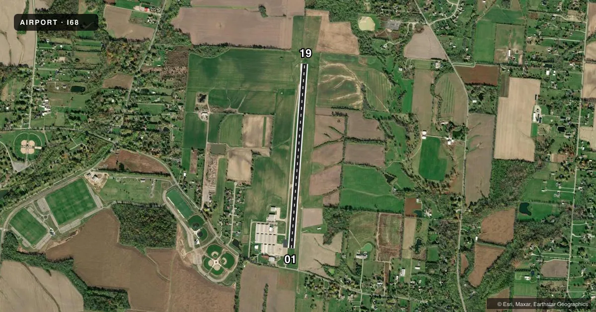
Runways & pattern
Full pagePattern entry · RWY 01
LEFT TRAFFICRunway end performance
| End | TORA | TODA | ASDA | LDA | VGSI | Approach lights | Obstruction |
|---|---|---|---|---|---|---|---|
| 01 | — | — | — | — | PAPI 4-box right(3.2°) | — | 8', crops, 201' from thr, 230' R of cntrln, slope 0 |
| 19 | — | — | — | — | PAPI 4-box left(3.5°) | — | 15', brush, 300' from thr, 90' R of cntrln, slope 6 |
Declared distances in feet. TORA = takeoff run available, TODA = takeoff distance, ASDA = accelerate-stop, LDA = landing distance.
Airport sketch
Runways drawn to scale from FAA survey coordinates, rendered over satellite imagery. Not for navigation.
Approaches & charts
Services on the field
Fuel grades, oxygen, maintenance, ramp storage and lighting — as declared to the FAA by the airport operator.
Fuel & services
- Fuel
- 100LLA+
- Oxygen (bottled)
- Low pressure
- Oxygen (bulk)
- Low pressure
- Airframe repair
- Major
- Power plant repair
- Major
- Other services
- INSTR,RNTL
Ramp & ground
- Transient storage
- Tie-down
- Hangar
- Landing fee
- No fee published
- Customs
- Not available
- Lighting schedule
- SEE RMK
- Beacon schedule
- SS-SR
- Beacon
- White / Green (civil land)(WG)
- Wind indicator
- Yes
- Segmented circle
- No
Fuel & FBOs
Cheapest 100LL and Jet A on the field and nearby. Always confirm with the FBO before taxi.
Airport notes
Surface conditions, obstructions, local procedures, lighting outages and other notes published with each FAA cycle.
General notes
- PAEW ADJ RWY & TWY INDEFLY.
- FOR CD CTC COLUMBUS APCH AT 614-338-8537.
- HOT AIR BLN OPS PSBL AT SR AND 1-2 HRS PRIOR TO SS.
- PFFD CALM WIND <5 KTS RWY 01
Lighting notes
- ACTVT REIL RWY 01 & 19; MIRL RWY 01/19 - 7 CLICKS CTAF.
Fuel notes
- 100LL100LL FULL SVC DURG ATNDD HRS; AVBL H24 SELF SVC VIA CREDIT CARD.
- A+JET A FULL SVC DURG ATNDD HRS.
Approach & departure obstructions
- 01+8 FT CROPS 200 FT FM EXTDNG TO DTHLD 230 FT R.
- 01RWY 01 PREFFERED CALM WIND LESS THAN 5 KTS.
- 01OBST CLNC SLP 0:1 TO DTHR.
- 01+5-15 FT BRUSH ALONG FENCE LINE 300 FT FM 90 FT R TO 270 FT L.
Other notes
- TNST HNGR PPR.
- MANAGERADNL CTC: 513-932-7966, FBO@WARRENCOUNTYAIRPORT.NET.
VFR map & nearby airports
VFR sectional. Tap any ICAO chip to open that airport.
Key facts · I68
Answer card- ICAO
- I68
- Name
- WARREN COUNTY/JOHN LANE FLD
- Location
- LEBANON, OHIO
- Elevation
- 897.9 ft MSL
- Traffic pattern altitude
- 1,897.9 ft MSL (1,000 AGL)
- Control tower
- Non-towered (use CTAF)
- Total runways
- 1
- Longest runway
- 01/19 · 4,505 ft
- Published ILS approaches
- 0
- Published frequencies
- 5
- Magnetic variation
- 5°
- Current flight rules
- VFR
- Current wind
- 000° at 0 kt
- Favored runway now
- –
Warren County/John Lane Fld (I68) sits in Lebanon, Ohio at 897.9 ft MSL. It has one asphalt runway. Runway 01/19 is 4,505 ft long, which is the longest runway on the field. The airport is non-towered. Pattern altitude is not published, so use the standard 1,000 ft AGL for light piston traffic unless the current Chart Supplement says otherwise.
No ILS approaches are published here. Clearance delivery is handled through Columbus Approach. The published remarks also note runway end identifier lights on 01 and 19. Medium intensity runway lights are available on 01/19 with seven clicks on CTAF. Runway 01 is listed as the preferred runway in calm winds under 5 knots.
Warren County Airport is the on-field FBO. It carries 100LL and Jet A. 100LL is available full service during attended hours. It is also available 24 hours self-serve by credit card. Jet A is full service during attended hours. Transient hangar use requires prior permission. There are also published obstructions near the 01 displaced threshold, including brush and crops close to the runway environment. Expect to brief the departure and arrival carefully if you are new to the field.