METAR & TAF KMGY
Current METAR
Observed 14:53Z
KMGY 271453Z AUTO 00000KT 10SM FEW002 26/22 A2995 RMK AO2 SLP134 T02560217 53003
- Wind
- 000° @ 0 kt
- Visibility
- 10 SM
- Temp / Dew
- 26°C / 22°C
- Altimeter
- 29.95 inHg
- Clouds
- FEW
- Density alt
- 2,469 ft
- Ceiling
- Unlimited
- Rules
- VFR
Airport info & contacts
Manager on record, flight service, ARTCC, attendance schedule and pattern altitude — published by the FAA and refreshed every 28 days.
Location
- From city
- 10 NM S
- VFR sectional
- CINCINNATI
- ARTCC
- ZID · INDIANAPOLIS
- NOTAM facility
- MGY (NOTAM-D)
Airport manager
- Name
- BRANDON ELLIS
- Phone
- 937-454-7897
- Address
- 3600 TERMINAL DR STE 300, VANDALIA OH 45377-1095
Flight service · Hours
- FSS DAY
- DAYTON1-800-WX-BRIEF
- Attendance
- 0700-2000
Frequencies
Tap any row to copy the frequency to your clipboard.
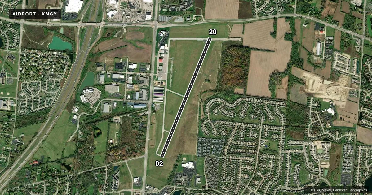
Runways & pattern
Full pagePattern entry · RWY 02
LEFT TRAFFICRunway end performance
| End | TORA | TODA | ASDA | LDA | VGSI | Approach lights | Obstruction |
|---|---|---|---|---|---|---|---|
| 02 | 5,000' | 5,000' | 4,700' | 4,700' | PAPI 2-box left(3°) | — | — |
| 20 | 5,000' | 5,000' | 5,000' | 4,410' | PAPI 4-box left(3°) | MALS | 25', road, 540' from thr, 300' R of cntrln, slope 13 |
Declared distances in feet. TORA = takeoff run available, TODA = takeoff distance, ASDA = accelerate-stop, LDA = landing distance.
Airport sketch
Runways drawn to scale from FAA survey coordinates, rendered over satellite imagery. Not for navigation.
Approaches & charts
ILS · 1
Services on the field
Fuel grades, oxygen, maintenance, ramp storage and lighting — as declared to the FAA by the airport operator.
Fuel & services
- Fuel
- 100LLAA+
- Oxygen (bottled)
- HIGH/LOW
- Oxygen (bulk)
- Not available
- Airframe repair
- Major
- Power plant repair
- Major
- Other services
- AFRT,CARGO,CHTR,INSTR,RNTL,SALES
Ramp & ground
- Transient storage
- Tie-down
- Hangar
- Landing fee
- No fee published
- Customs
- Not available
- Lighting schedule
- SEE RMK
- Beacon schedule
- SS-SR
- Beacon
- White / Green (civil land)(WG)
- Wind indicator
- Lighted
- Segmented circle
- No
Fuel & FBOs
Cheapest 100LL and Jet A on the field and nearby. Always confirm with the FBO before taxi.
Airport notes
Surface conditions, obstructions, local procedures, lighting outages and other notes published with each FAA cycle.
General notes
- DEER, BIRDS, & OTR WILDLIFE ON & INVOF ARPT.
- SFC CONDS UNMON 1530-0700 WKDAYS & ALL DAY WKENDS/HOLS.
- FULL PWR MAINT RUNUPS PROHIBITED IN THE HLDG APN AT THE NW CORNER OF TWY A 0800-1700 WKDAYS.
Lighting notes
- ACTVT MALS RWY 20; PAPI RWY 02 & 20; MIRL RWY 02/20 - CTAF. TWY LGTS OPR CONSLY SS-SR.
Approach & departure obstructions
- 20PAPI UNUSBL BYD 7 DEGS RIGHT OF CNTRLN.
- 20APCH SLP 34:1 TO DTHR.
Other notes
- THIS AIRPORT HAS BEEN SURVEYED BY THE NATIONAL GEODETIC SURVEY.
- PRIOR CDN RQRD.
- MANAGERCELL 937-776-2194.
VFR map & nearby airports
VFR sectional. Tap any ICAO chip to open that airport.
Key facts · KMGY
Answer card- ICAO
- KMGY
- Name
- DAYTON/WRIGHT BROTHERS
- Location
- DAYTON, OHIO
- Elevation
- 956.6 ft MSL
- Traffic pattern altitude
- 1,956.6 ft MSL (1,000 AGL)
- Control tower
- Non-towered (use CTAF)
- Total runways
- 1
- Longest runway
- 02/20 · 5,000 ft
- Published ILS approaches
- 1
- Published frequencies
- 5
- Magnetic variation
- 4°
- Current flight rules
- VFR
- Current wind
- 000° at 0 kt
- Favored runway now
- –
Dayton/Wright Brothers Airport sits in Dayton, Ohio. Field elevation is 956.6 ft MSL. The airport has one runway, 02/20, which is 5,000 ft long. There is no control tower. Towered services are handled through Columbus approach and departure on the published frequencies. One ILS is available for runway 20.
Pattern altitude is not published. Use 1,000 ft AGL for light piston traffic unless the current Chart Supplement says otherwise. The field has one on-field FBO, First Flight Aviation. It carries 100LL, Jet A and Jet A Prist. Call ahead at (937) 885-5580 x122. Prior coordination is required. That matters here.
A few remarks are worth planning around. Full power runups are prohibited in the holding apron at the northwest corner of taxiway A from 0800 to 1700 on weekdays. Surface conditions are unmonitored from 1530 to 0700 on weekdays. They are also unmonitored all day on weekends and holidays. Runway 20 has a displaced threshold with a steep approach slope to the threshold. The PAPI on runway 20 is unusable beyond 7 degrees right of centerline. Wildlife is also reported on and near the airport. Check the current Chart Supplement before departure for any current restrictions or changes.