METAR & TAF KSGH
Current METAR
Observed 15:56Z
KSGH 271556Z AUTO 27005KT 10SM CLR 27/21 A2994 RMK AO2 SLP133 T02720211
- Wind
- 270° @ 5 kt
- Visibility
- 10 SM
- Temp / Dew
- 27°C / 21°C
- Altimeter
- 29.94 inHg
- Clouds
- CLR
- Density alt
- 2,719 ft
- Ceiling
- Unlimited
- Rules
- VFR
Airport info & contacts
Manager on record, flight service, ARTCC, attendance schedule and pattern altitude — published by the FAA and refreshed every 28 days.
Location
- From city
- 5 NM SSW
- VFR sectional
- CINCINNATI
- Pattern altitude
- 1,049 ft AGL · 2,100 ft MSL
- ARTCC
- ZID · INDIANAPOLIS
- NOTAM facility
- SGH (NOTAM-D)
Airport manager
- Name
- DRAKE HUFFMAN
- Phone
- 937-325-6108
- Address
- 1251 W BLEE RD, SPRINGFIELD OH 45502-8729
Flight service · Hours
- FSS DAY
- DAYTON1-800-WX-BRIEF
- Attendance
- MON-FRI · 0730-1600
Frequencies
Tap any row to copy the frequency to your clipboard.
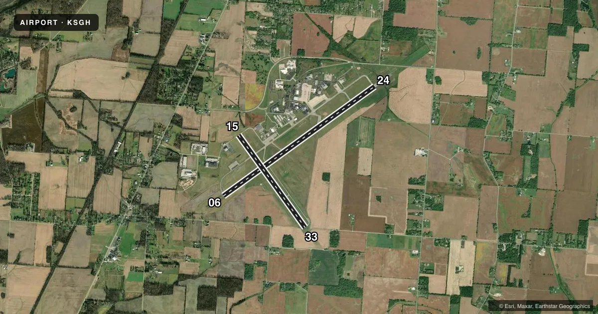
Runways & pattern
Full pagePattern entry · RWY 24
LEFT TRAFFIC| Runway | Heading (°M) | Length | Surface | Traffic |
|---|---|---|---|---|
| 06/24Favored | 50° / 230° | 9,010 ft | ASPH-CONC | Standard L |
| 15/33 | 140° / 320° | 5,498 ft | ASPH | Standard L |
Runway end performance
| End | TORA | TODA | ASDA | LDA | VGSI | Approach lights | Obstruction |
|---|---|---|---|---|---|---|---|
| 06 | 9,009' | 9,009' | 9,009' | 9,009' | PAPI 4-box left(3°) | — | 58', trees, 1697' from thr, 161' R of cntrln, slope 25 |
| 24 | 9,009' | 9,009' | 9,009' | 9,009' | PAPI 4-box left(3°) | SSALR | 70', tree, 1939' from thr, 462' R of cntrln, slope 24 |
| 15 | 5,499' | 5,499' | 5,499' | 5,499' | PAPI 4-box left(3°) | — | 7', crops, 287' from thr, 131' R of cntrln, slope 12 |
| 33 | 5,499' | 5,499' | 5,499' | 5,499' | PAPI 4-box left(3°) | — | 55', trees, 1450' from thr, 154' R of cntrln, slope 22 |
Declared distances in feet. TORA = takeoff run available, TODA = takeoff distance, ASDA = accelerate-stop, LDA = landing distance.
Airport sketch
Runways drawn to scale from FAA survey coordinates, rendered over satellite imagery. Not for navigation.
Approaches & charts
Services on the field
Fuel grades, oxygen, maintenance, ramp storage and lighting — as declared to the FAA by the airport operator.
Fuel & services
- Fuel
- 100LLA+
- Oxygen (bottled)
- Low pressure
- Oxygen (bulk)
- High pressure
- Airframe repair
- Major
- Power plant repair
- Major
- Other services
- AVNCS,INSTR,SALES
Ramp & ground
- Transient storage
- Tie-down
- Hangar
- Landing fee
- No fee published
- Customs
- Not available
- Lighting schedule
- SEE RMK
- Beacon schedule
- SS-SR
- Beacon
- White / Green (civil land)(WG)
- Wind indicator
- Lighted
- Segmented circle
- No
Fuel & FBOs
Cheapest 100LL and Jet A on the field and nearby. Always confirm with the FBO before taxi.
Airport notes
Surface conditions, obstructions, local procedures, lighting outages and other notes published with each FAA cycle.
General notes
- OCNL DEER, BIRDS, & OTR WILDLIFE ON & INVOF ARPT.
- HVY BIRD ACT DRG FALL & WINTER MONTHS.
- NOISE ABATEMENT: AVOID OVERFLYING YELLOW SPRINGS 2 NM SW BLW 4000 FT.
- AVOID OVERFLYING ANG RAMP.
- FOR CD CTC COLUMBUS APCH AT 614-338-8537.
Lighting notes
- ACTVT WIND CONE; SSALR RWY 24; REIL RWY 06, 15, & 33; HIRL RWY 06/24; MIRL RWY 15/33 - CTAF. PAPI RWY 06, 24, 15, & 33 OPR CONSLY.
Approach & departure obstructions
- 24ALS UNMON INDEFLY.
- 24CALM WIND RWY.
- 15PAPI UNUSBL BYD 9 DEGS RIGHT OF CNTRLN.
Other notes
- OHD TPA 1549 FT AGL.
- PRIOR CDN RQRD.
- MANAGERSGH.FBO@SPRINGFIELDOHIO.GOV.
- MANAGEROR 937-323-5804.
- 06/24NE 980 FT CONC, SW 1200 FT CONC, 6830 FT ASPH BTN.
VFR map & nearby airports
VFR sectional. Tap any ICAO chip to open that airport.
Key facts · KSGH
Answer card- ICAO
- KSGH
- Name
- SPRINGFIELD/BECKLEY MUNI
- Location
- SPRINGFIELD, OHIO
- Elevation
- 1,051.3 ft MSL
- Traffic pattern altitude
- 2,100.3 ft MSL (1,049 AGL)
- Control tower
- Non-towered (use CTAF)
- Total runways
- 2
- Longest runway
- 06/24 · 9,010 ft
- Published ILS approaches
- 0
- Published frequencies
- 4
- Magnetic variation
- 4°
- Current flight rules
- VFR
- Current wind
- 270° at 5 kt
- Favored runway now
- RWY 24
Springfield/Beckley Muni is in Springfield, Ohio. Field elevation is 1,051.3 ft MSL. The airport has two runways. The longest is 06/24 at 9,010 ft. Runway 15/33 is 5,498 ft. There is no control tower, so plan to use CTAF 122.95 and coordinate as needed. No ILS approaches are published here.
The pattern altitude is 1,549 ft AGL. That puts the overhead traffic pattern at 2,100.3 ft MSL. The field sits in a busy part of western Ohio, so expect normal midcontinent traffic flow and pay attention to the published noise note. Avoid overflying Yellow Springs 2 NM southwest below 4,000 ft. Wildlife is also a real factor here. The Chart Supplement notes occasional deer and birds on or near the airport. Heavy bird activity is common in fall and winter.
Springfield-Beckley Municipal Airport is the on-field FBO. It carries 100LL and Jet A Prist. Prior coordination is required. Contact the manager before arrival if you need handling or want to confirm current field details. Lighting is straightforward for a non-towered field. Runway 06/24 has high intensity lights. Runway 15/33 has medium intensity lights. PAPI is published on all four runway ends. The PAPI on 15 is unusable beyond 9 degrees right of centerline. Runway 24 also has an approach lighting system that is unmonitored indefinitely.