METAR & TAF 38I
38I does not publish a METAR.
Showing the nearest reporting station: KUYF (MADISON COUNTY) · 14.1 NM away. Conditions at 38I may differ.
METAR · KUYF
Observed 17:15Z
KUYF 271715Z AUTO 22003KT 10SM SCT075 SCT090 SCT120 26/21 A2991 RMK AO2
- Wind
- 220° @ 3 kt
- Visibility
- 10 SM
- Temp / Dew
- 26°C / 21°C
- Altimeter
- 29.91 inHg
- Clouds
- SCT
- Density alt
- 2,758 ft
- Ceiling
- Unlimited
- Rules
- VFR
Airport info & contacts
Manager on record, flight service, ARTCC, attendance schedule and pattern altitude — published by the FAA and refreshed every 28 days.
Location
- From city
- 3 NM ESE
- VFR sectional
- DETROIT
- ARTCC
- ZID · INDIANAPOLIS
- NOTAM facility
- DAY (NOTAM-D)
Airport manager
- Name
- CHRISTOPHER COOK
- Phone
- 937-360-5308
- Address
- 8761 WILDLANE DR, SOUTH CHARLESTON OH 45368-7787
Flight service · Hours
- FSS DAY
- DAYTON1-800-WX-BRIEF
- Attendance
- Unattended
Frequencies
Tap any row to copy the frequency to your clipboard.
Runways & pattern
Full pagePattern entry · RWY 27
LEFT TRAFFICRunway end performance
| End | TORA | TODA | ASDA | LDA | VGSI | Approach lights | Obstruction |
|---|---|---|---|---|---|---|---|
| 09 | — | — | — | — | — | — | 70', trees, 48' from thr, 67' R of cntrln, slope 0 |
| 27 | — | — | — | — | — | — | 10', crops, 60' from thr, 125' R of cntrln, slope 6 |
Declared distances in feet. TORA = takeoff run available, TODA = takeoff distance, ASDA = accelerate-stop, LDA = landing distance.
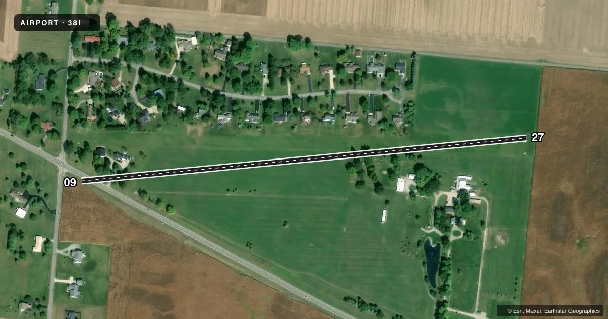
Airport sketch
Runways drawn to scale from FAA survey coordinates, rendered over satellite imagery. Not for navigation.
Approaches & charts
Services on the field
Fuel grades, oxygen, maintenance, ramp storage and lighting — as declared to the FAA by the airport operator.
Fuel & services
- Fuel
- Not available
- Oxygen (bottled)
- Not available
- Oxygen (bulk)
- Not available
- Airframe repair
- Not available
- Power plant repair
- Not available
Ramp & ground
- Transient storage
- Tie-down
- Landing fee
- No fee published
- Customs
- Not available
- Wind indicator
- Yes
- Segmented circle
- No
Fuel & FBOs
Cheapest 100LL and Jet A on the field and nearby. Always confirm with the FBO before taxi.
Airport notes
Surface conditions, obstructions, local procedures, lighting outages and other notes published with each FAA cycle.
General notes
- FOR CD CTC COLUMBUS APCH AT 614-338-8537.
Approach & departure obstructions
- 09RWY OUTLINED WITH YELLOW TIRES; RWY END MKD WITH YELLOW CONC PANELS.
- 27RWY OUTLINED WITH YELLOW TIRES; RWY END MKD WITH YELLOW CONC PANELS.
- 09CTLG OBSTN EXCEEDS A 45 DEG SLP.
Other notes
- VFR ONLY.
- FOR LCTN OF TIEDOWN AREAS CALL AMGR.
- MANAGERARPT PHYS LCTN: JUST NORTH OF 3138 E STATE ROUTE 29, URBANA OH 43078.
VFR map & nearby airports
VFR sectional. Tap any ICAO chip to open that airport.
Key facts · 38I
Answer card- ICAO
- 38I
- Name
- COOK
- Location
- URBANA, OHIO
- Elevation
- 1,150 ft MSL
- Traffic pattern altitude
- 2,150 ft MSL (1,000 AGL)
- Control tower
- Non-towered (use CTAF)
- Total runways
- 1
- Longest runway
- 09/27 · 2,650 ft
- Published ILS approaches
- 0
- Published frequencies
- 2
- Magnetic variation
- –
- Current flight rules
- VFR
- Current wind
- 220° at 3 kt
- Favored runway now
- RWY 27
COOK (38I) sits in Urbana, Ohio. The field elevation is 1,150 ft MSL. It has one runway. Runway 09/27 is 2,650 ft of turf, so plan for soft-field technique and check the surface before you go. No control tower is published here. CTAF and UNICOM are both 123.0. No ILS approaches are published.
Pattern altitude is not published. Use the standard 1,000 ft AGL pattern unless the current Chart Supplement or the airport operator tells you otherwise. The published remarks say this is VFR only. That matters here. There is also a cataloged obstruction near runway 09 that exceeds a 45 degree slope, so give yourself a careful look at departure and arrival paths. Runway 09 and runway 27 are both outlined with yellow tires. The runway ends are marked with yellow concrete panels.
No on-field FBOs are listed. For tiedown locations, call the airport manager. The airport physical location is just north of 3138 E State Route 29 in Urbana. If you need clearance delivery, contact Columbus Approach at 614-338-8537. For a first-time arrival, verify current field condition and any local procedures before you launch.