METAR & TAF I54
I54 does not publish a METAR.
Showing the nearest reporting station: KSGH (SPRINGFIELD/BECKLEY MUNI) · 10.8 NM away. Conditions at I54 may differ.
METAR · KSGH
Observed 12:56Z
KSGH 261256Z AUTO 35004KT 10SM OVC028 21/19 A3000 RMK AO2 SLP153 T02060189
- Wind
- 350° @ 4 kt
- Visibility
- 10 SM
- Temp / Dew
- 21°C / 19°C
- Altimeter
- 30.00 inHg
- Clouds
- OVC
- Density alt
- 1,809 ft
- Ceiling
- 2,800 ft AGL
- Rules
- MVFR
Airport info & contacts
Manager on record, flight service, ARTCC, attendance schedule and pattern altitude — published by the FAA and refreshed every 28 days.
Location
- From city
- 1 NM NE
- VFR sectional
- DETROIT
- Pattern altitude
- 845 ft AGL · 1,803 ft MSL
- ARTCC
- ZID · INDIANAPOLIS
- NOTAM facility
- DAY (NOTAM-D)
Airport manager
- Name
- JEREMIAH BROWN
- Phone
- 618-351-9768
- Address
- 6488 UPPER VALLEY PIKE, URBANA OH 43078-9100
Flight service · Hours
- FSS DAY
- DAYTON1-800-WX-BRIEF
- Attendance
- Unattended
Frequencies
Tap any row to copy the frequency to your clipboard.
Runways & pattern
Full pagePattern entry · RWY 27
LEFT TRAFFICRunway end performance
| End | TORA | TODA | ASDA | LDA | VGSI | Approach lights | Obstruction |
|---|---|---|---|---|---|---|---|
| 09 | — | — | — | — | — | — | 25', pole, 0' from thr, 60' R of cntrln, slope 0 |
| 27 | — | — | — | — | — | — | 15', pole, 0' from thr, 60' R of cntrln, slope 0 |
Declared distances in feet. TORA = takeoff run available, TODA = takeoff distance, ASDA = accelerate-stop, LDA = landing distance.
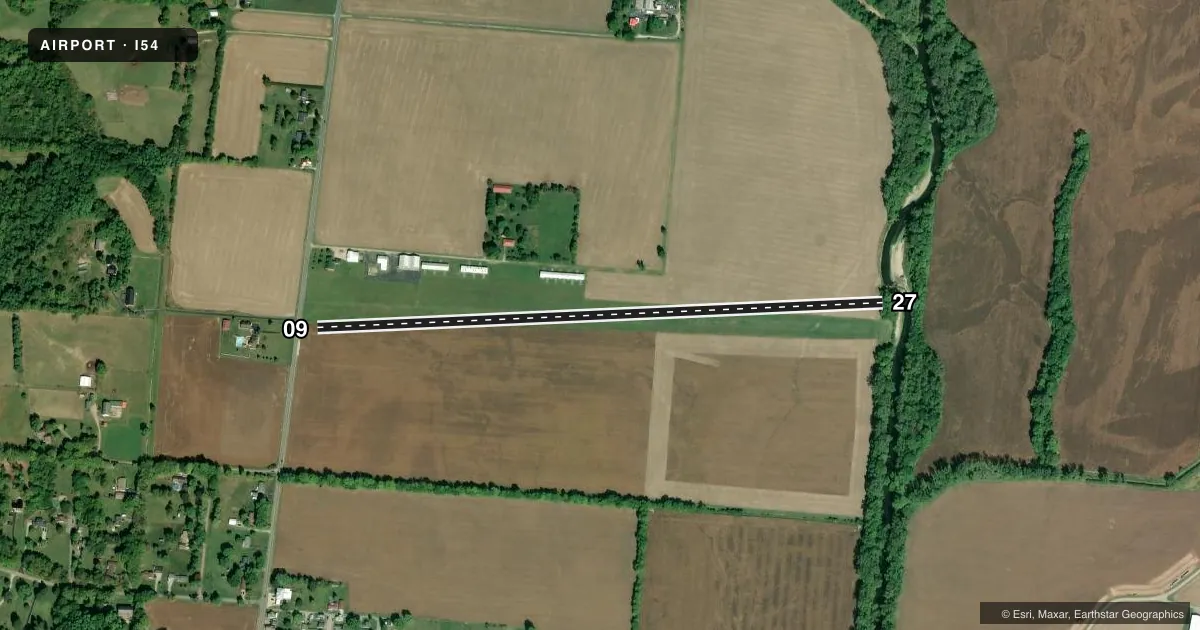
Airport sketch
Runways drawn to scale from FAA survey coordinates, rendered over satellite imagery. Not for navigation.
Approaches & charts
Services on the field
Fuel grades, oxygen, maintenance, ramp storage and lighting — as declared to the FAA by the airport operator.
Fuel & services
- Fuel
- Not available
- Oxygen (bottled)
- Not available
- Oxygen (bulk)
- Not available
- Airframe repair
- Not available
- Power plant repair
- Not available
Ramp & ground
- Transient storage
- Tie-down
- Hangar
- Landing fee
- No fee published
- Customs
- Not available
- Lighting schedule
- SEE RMK
- Wind indicator
- Yes
- Segmented circle
- No
Fuel & FBOs
Cheapest 100LL and Jet A on the field and nearby. Always confirm with the FBO before taxi.
Airport notes
Surface conditions, obstructions, local procedures, lighting outages and other notes published with each FAA cycle.
General notes
- FOR CD CTC COLUMBUS APCH AT 614-338-8537.
Lighting notes
- ACTVT NSTD LIRL RWY 09/27 - 122.8.
Runway surface & condition
- 09/27NSTD LIRL DUE TO ONLY 2165 FT LGTD BTN DTHRS.
- 09/27MID 50 FT MOWED.
Approach & departure obstructions
- 09WEST 340 FT & EAST 900 FT NOT MKD; ONLY 2560 FT MKD WITH WHITE CONES; DTHR MKD WITH ONE CONE & GREEN LGT EACH SIDE OF RWY.
- 27WEST 340 FT & EAST 900 FT NOT MKD; ONLY 2560 FT MKD WITH WHITE CONES; DTHR MKD WITH ONE CONE & GREEN LGT EACH SIDE OF RWY.
- 09APCH SLP 9:1 TO DTHR OVR 201 FT WOODED HILL, 1955 FT DIST.
- 27APCH SLP 10:1 TO DTHR OVR 109 FT TREES, 1100 FT DIST, 125 FT R.
Other notes
- VFR ONLY.
VFR map & nearby airports
VFR sectional. Tap any ICAO chip to open that airport.
Key facts · I54
Answer card- ICAO
- I54
- Name
- MAD RIVER AIRPARK
- Location
- TREMONT CITY, OHIO
- Elevation
- 958 ft MSL
- Traffic pattern altitude
- 1,803 ft MSL (845 AGL)
- Control tower
- Non-towered (use CTAF)
- Total runways
- 1
- Longest runway
- 09/27 · 3,405 ft
- Published ILS approaches
- 0
- Published frequencies
- 4
- Magnetic variation
- –
- Current flight rules
- MVFR
- Current wind
- 350° at 4 kt
- Favored runway now
- RWY 27
Mad River Airpark sits near Tremont City, Ohio. Field elevation is 958 ft MSL. This is a small VFR-only field with one runway. The runway is 09/27 and it is 3,405 ft long on turf. The airport has no control tower. Traffic pattern altitude is 845 ft AGL, which is 1,803 ft MSL.
There are no published ILS approaches here. If you need IFR clearance delivery, the Chart Supplement lists Columbus Approach at 614-338-8537. The published remarks matter here. Runway 09/27 has displaced thresholds. Only 2,560 ft is marked with white cones. The west 340 ft and east 900 ft are not marked. The runway lighting is nonstandard low-intensity lighting. It is activated on 122.8. The middle 50 ft of the runway is mowed.
The airport has no on-field FBOs listed. Plan on confirming services directly with the airport operator or by calling the field on CTAF or UNICOM before you go. The approach paths also have notable obstacles. Runway 09 has a wooded hill on approach. Runway 27 has trees off the right side near the threshold. For a first-time arrival, treat this as a short-field planning airport with turf, displaced thresholds and limited marked runway length. Verify current conditions before departure, especially after rain or during soft-field season.