METAR & TAF I74
Current METAR
Observed 05:55Z
KI74 260555Z AUTO 00000KT 4SM BR SCT039 16/16 A2999 RMK AO2
- Wind
- 000° @ 0 kt
- Visibility
- 4 SM
- Temp / Dew
- 16°C / 16°C
- Altimeter
- 29.99 inHg
- Clouds
- SCT
- Density alt
- 1,357 ft
- Ceiling
- Unlimited
- Rules
- MVFR
Airport info & contacts
Manager on record, flight service, ARTCC, attendance schedule and pattern altitude — published by the FAA and refreshed every 28 days.
Location
- From city
- 1 NM N
- VFR sectional
- DETROIT
- ARTCC
- ZID · INDIANAPOLIS
- NOTAM facility
- I74 (NOTAM-D)
Airport manager
- Name
- DRAKE HUFFMAN
- Phone
- 937-652-4319
- Address
- 1636 N MAIN ST, URBANA OH 43078-5001
Flight service · Hours
- FSS DAY
- DAYTON1-800-WX-BRIEF
- Attendance
- MON-FRI · 0800-1600
Frequencies
Tap any row to copy the frequency to your clipboard.
Runways & pattern
Full pagePattern entry · RWY 02
LEFT TRAFFIC| Runway | Heading (°M) | Length | Surface | Traffic |
|---|---|---|---|---|
| 02/20 | 14° / 194° | 4,400 ft | ASPH | Standard L |
| 01/19 | 4° / 184° | 3,000 ft | TURF | Standard L |
Runway end performance
| End | TORA | TODA | ASDA | LDA | VGSI | Approach lights | Obstruction |
|---|---|---|---|---|---|---|---|
| 02 | — | — | — | — | PAPI 4-box right(3°) | — | — |
| 20 | — | — | — | — | PAPI 4-box left(3°) | — | — |
Declared distances in feet. TORA = takeoff run available, TODA = takeoff distance, ASDA = accelerate-stop, LDA = landing distance.
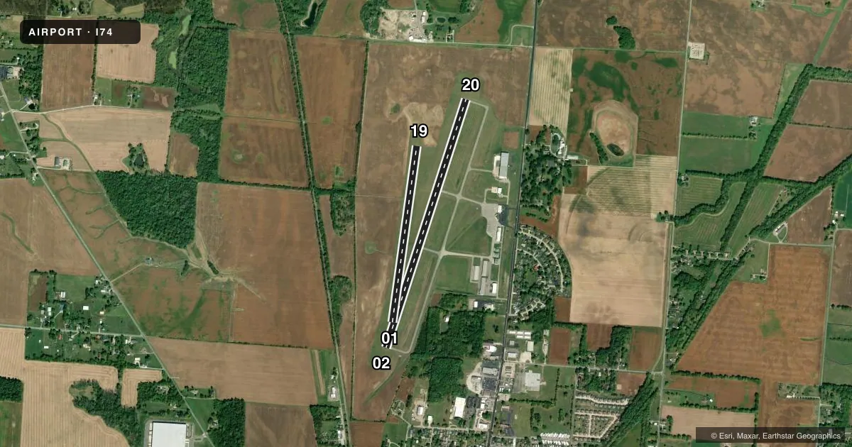
Airport sketch
Runways drawn to scale from FAA survey coordinates, rendered over satellite imagery. Not for navigation.
Approaches & charts
Services on the field
Fuel grades, oxygen, maintenance, ramp storage and lighting — as declared to the FAA by the airport operator.
Fuel & services
- Fuel
- 100LLA+
- Oxygen (bottled)
- Not available
- Oxygen (bulk)
- Not available
- Airframe repair
- Minor
- Power plant repair
- Minor
- Other services
- AGRI,AMB,CHTR,INSTR
Ramp & ground
- Transient storage
- Tie-down
- Hangar
- Landing fee
- Yes
- Customs
- Not available
- Lighting schedule
- SEE RMK
- Beacon schedule
- SS-SR
- Beacon
- White / Green (civil land)(WG)
- Wind indicator
- Lighted
- Segmented circle
- No
Fuel & FBOs
Cheapest 100LL and Jet A on the field and nearby. Always confirm with the FBO before taxi.
Airport notes
Surface conditions, obstructions, local procedures, lighting outages and other notes published with each FAA cycle.
General notes
- FOR CD CTC COLUMBUS APCH AT 614-338-8537.
- BIRDS & DEER ON & INVOF ARPT.
- 125 FT WATER TWR, 1 NM SOUTH.
Lighting notes
- ACTVT REIL RWY 02 & 20; MIRL RWY 02/20 - CTAF.
Fuel notes
- 100LL100LL & JET A+ AVBL H24 SELF SVC VIA CREDIT CARD.
Approach & departure obstructions
- 20CALM WIND RWY.
- 01YELLOW CONES.
- 19YELLOW CONES.
Other notes
- ESTABD BFR 1959.
- LDG FEE FOR ACFT WITH MAX LDG WT 6000 LB OR GTR - WAIVED WITH MNM FUEL PURCHASE.
- PRIOR CDN RQRD FOR HNGR.
- 1UNATNDD MAJOR HOLS.
- MANAGERCELL 740-995-9919.
VFR map & nearby airports
VFR sectional. Tap any ICAO chip to open that airport.
Key facts · I74
Answer card- ICAO
- I74
- Name
- GRIMES FLD
- Location
- URBANA, OHIO
- Elevation
- 1,067.9 ft MSL
- Traffic pattern altitude
- 2,067.9 ft MSL (1,000 AGL)
- Control tower
- Non-towered (use CTAF)
- Total runways
- 2
- Longest runway
- 02/20 · 4,400 ft
- Published ILS approaches
- 0
- Published frequencies
- 4
- Magnetic variation
- 4°
- Current flight rules
- MVFR
- Current wind
- 000° at 0 kt
- Favored runway now
- –
Grimes Field sits in Urbana, Ohio. The field elevation is 1,067.9 ft MSL. It has two runways. The longest is 4,400 ft asphalt runway 02/20. Runway 01/19 is 3,000 ft turf. The airport is non-towered. No ILS approaches are published here.
Pattern altitude is not published. Use 1,000 ft AGL for light piston operations unless the current Chart Supplement says otherwise. The field carries CTAF and UNICOM on 122.7. Columbus Approach handles approach and departure services on 134.45 and 294.5. For clearance delivery, contact Columbus Approach at 614-338-8537.
Grimes Field has one on-field FBO. Grimes Field carries 100LL and Jet A+ and offers 24-hour self-serve fuel by credit card. The airport remarks also note birds and deer in the area. A 125-foot water tower sits about 1 NM south of the airport. Runway 20 is the calm wind runway. Runway end identifier lights are on 02 and 20. Medium intensity runway lights on 02 and 20 are controlled by CTAF. Yellow cones mark the ends of 01 and 19.
For a first-time arrival, plan for a quiet non-towered field with local wildlife and a nearby tower obstacle. Check the current Chart Supplement for any changes before you go. The airport is unattended on major holidays. Prior coordination is required for hangar use.