METAR & TAF 1WF
1WF does not publish a METAR.
Showing the nearest reporting station: KDAY (JAMES M COX DAYTON INTL) · 6.8 NM away. Conditions at 1WF may differ.
METAR · KDAY
Observed 16:56Z
KDAY 271656Z 27005KT 10SM FEW025 SCT150 BKN180 28/21 A2992 RMK AO2 SLP123 T02780206
- Wind
- 270° @ 5 kt
- Visibility
- 10 SM
- Temp / Dew
- 28°C / 21°C
- Altimeter
- 29.92 inHg
- Clouds
- BKN
- Density alt
- 2,573 ft
- Ceiling
- 18,000 ft AGL
- Rules
- VFR
Airport info & contacts
Manager on record, flight service, ARTCC, attendance schedule and pattern altitude — published by the FAA and refreshed every 28 days.
Location
- From city
- 2 NM S
- VFR sectional
- DETROIT
- ARTCC
- ZID · INDIANAPOLIS
- NOTAM facility
- DAY (NOTAM-D)
Airport manager
- Name
- RUSSELL BERRY
- Phone
- 937-405-7183
- Address
- 1865 S COUNTY ROAD 25A, TROY OH 45373-4251
Flight service · Hours
- FSS DAY
- DAYTON1-800-WX-BRIEF
- Attendance
- MON-TUE · 0900-1330
- SAT-SUN · 1200-1700
- THU-FRI · 0900-1330
Frequencies
Tap any row to copy the frequency to your clipboard.
Runways & pattern
Full pagePattern entry · RWY 36
LEFT TRAFFICRunway end performance
| End | TORA | TODA | ASDA | LDA | VGSI | Approach lights | Obstruction |
|---|---|---|---|---|---|---|---|
| 18 | — | — | — | — | — | — | 45', bldg, 400' from thr, 85' R of cntrln, slope 8 |
| 36 | — | — | — | — | — | — | 75', tree, 1020' from thr, 178' R of cntrln, slope 13 |
Declared distances in feet. TORA = takeoff run available, TODA = takeoff distance, ASDA = accelerate-stop, LDA = landing distance.
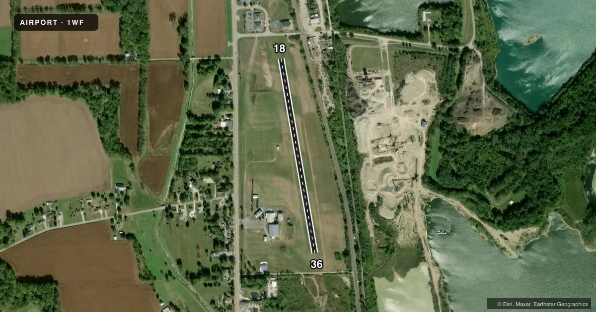
Airport sketch
Runways drawn to scale from FAA survey coordinates, rendered over satellite imagery. Not for navigation.
Approaches & charts
Services on the field
Fuel grades, oxygen, maintenance, ramp storage and lighting — as declared to the FAA by the airport operator.
Fuel & services
- Fuel
- Not available
- Oxygen (bottled)
- Not available
- Oxygen (bulk)
- Not available
- Airframe repair
- Not available
- Power plant repair
- Not available
Ramp & ground
- Transient storage
- Tie-down
- Wind indicator
- Yes
- Segmented circle
- No
Fuel & FBOs
Cheapest 100LL and Jet A on the field and nearby. Always confirm with the FBO before taxi.
Airport notes
Surface conditions, obstructions, local procedures, lighting outages and other notes published with each FAA cycle.
General notes
- UAS OPS ON THE FLD ANNC INTNS ON CTAF & OVERFLY THE FLD; UAS SHOULD LND CNSTNT WITH LOA ON FILE WITH ARPT.
- OCNL DEER, BIRDS, & OTR WILDLIFE ON & INVOF ARPT.
- FOR CD CTC COLUMBUS APCH AT 614-338-8537.
Approach & departure obstructions
- 18THR & DTHR MKD WITH WHITE BARRELS.
- 36THR MKD WITH WHITE BARRELS.
- 18OBST CLNC SLP 20:1 TO DTHR DUE TO +45 FT UNMKD/UNLGTD BLDG, 400 FT DIST, 85 FT L OF CL; +40 FT MKD PLINE/POLE, 334 FT DIST, ON CL.
Other notes
- PRVDD CLEAR 20:1 APCHS; CLEAR OBST FREE ZONE; CLEAR RWY SAFETY AREA.
- TIEDOWN ANCHORS & ROPES NOT PRVDD.
- OWNERADMIN@WACOAIRMUSEUM.ORG.
VFR map & nearby airports
VFR sectional. Tap any ICAO chip to open that airport.
Key facts · 1WF
Answer card- ICAO
- 1WF
- Name
- WACO FLD
- Location
- TROY, OHIO
- Elevation
- 817 ft MSL
- Traffic pattern altitude
- 1,817 ft MSL (1,000 AGL)
- Control tower
- Non-towered (use CTAF)
- Total runways
- 1
- Longest runway
- 18/36 · 2,385 ft
- Published ILS approaches
- 0
- Published frequencies
- 1
- Magnetic variation
- 5°
- Current flight rules
- VFR
- Current wind
- 270° at 5 kt
- Favored runway now
- RWY 36
WACO FLD sits in Troy, Ohio at 817 ft MSL. It has one runway, 18/36, which is 2,385 ft of turf. The field is not towered. CTAF is 122.9. No ILS approaches are published here.
Pattern altitude is not published. Use the standard 1,000 ft AGL for light piston operations unless the current Chart Supplement says otherwise. The runway headings are magnetic at 170° and 350°. The airport sits under 5° magnetic variation.
There are no on-field FBOs listed. Plan for self-sufficiency on arrival. Tiedown anchors and ropes are not provided. The published remarks also note UAS activity on the field. Pilots should listen on CTAF and overfly as needed to stay clear of drone operations. Clearance delivery can be coordinated with Columbus Approach at 614-338-8537.
Runway 18 has white barrel markings at the threshold and departure threshold. The departure end also has a published obstacle issue. A building and a power line or pole sit off the departure path, so performance and climb planning matter here. Wildlife can also be present. Expect deer or birds near the airport. If you are new to the field, review the current Chart Supplement before you go and keep your departure and arrival planning conservative.