METAR & TAF I17
I17 does not publish a METAR.
Showing the nearest reporting station: KVES (DARKE COUNTY) · 10.5 NM away. Conditions at I17 may differ.
METAR · KVES
Observed 17:15Z
KVES 271715Z AUTO VRB06KT 10SM CLR 28/23 A2987 RMK AO2 PRESFR
- Wind
- VAR @ 6 kt
- Visibility
- 10 SM
- Temp / Dew
- 28°C / 23°C
- Altimeter
- 29.87 inHg
- Clouds
- CLR
- Density alt
- 2,853 ft
- Ceiling
- Unlimited
- Rules
- VFR
Airport info & contacts
Manager on record, flight service, ARTCC, attendance schedule and pattern altitude — published by the FAA and refreshed every 28 days.
Location
- From city
- 3 NM NW
- VFR sectional
- DETROIT
- ARTCC
- ZID · INDIANAPOLIS
- NOTAM facility
- DAY (NOTAM-D)
Airport manager
- Name
- BRADYN RANSDELL
- Phone
- 937-778-5742
- Address
- 1 PROPELLER PL, PIQUA OH 45356-2655
Flight service · Hours
- FSS DAY
- DAYTON1-800-WX-BRIEF
- Attendance
- MON-FRI · 0800-1700
Frequencies
Tap any row to copy the frequency to your clipboard.
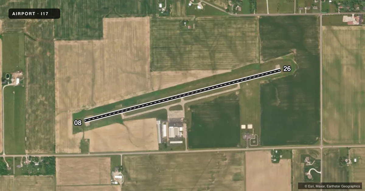
Runways & pattern
Full pagePattern entry · RWY 08
LEFT TRAFFICRunway end performance
| End | TORA | TODA | ASDA | LDA | VGSI | Approach lights | Obstruction |
|---|---|---|---|---|---|---|---|
| 08 | — | — | — | — | PAPI 2-box left(3°) | — | 8', crops, 201' from thr, 200' R of cntrln, slope 0 |
| 26 | — | — | — | — | PAPI 2-box left(3°) | — | 3', crops, 201' from thr, 135' R of cntrln, slope 0 |
Declared distances in feet. TORA = takeoff run available, TODA = takeoff distance, ASDA = accelerate-stop, LDA = landing distance.
Airport sketch
Runways drawn to scale from FAA survey coordinates, rendered over satellite imagery. Not for navigation.
Approaches & charts
Services on the field
Fuel grades, oxygen, maintenance, ramp storage and lighting — as declared to the FAA by the airport operator.
Fuel & services
- Fuel
- 100LLA+A1+
- Oxygen (bottled)
- Not available
- Oxygen (bulk)
- Not available
- Airframe repair
- Minor
- Power plant repair
- Minor
Ramp & ground
- Transient storage
- Tie-down
- Hangar
- Landing fee
- No fee published
- Customs
- Not available
- Lighting schedule
- SEE RMK
- Beacon schedule
- SS-SR
- Beacon
- White / Green (civil land)(WG)
- Wind indicator
- Lighted
- Segmented circle
- No
Fuel & FBOs
Cheapest 100LL and Jet A on the field and nearby. Always confirm with the FBO before taxi.
Airport notes
Surface conditions, obstructions, local procedures, lighting outages and other notes published with each FAA cycle.
General notes
- AEROBATIC BOX LCTD WI 1 NMR OF ARPT, BLW 4500 FT MSL, SR-SS.
- ARPT CONDS UNMON MON-FRI 1600-0800, SAT-SUN, & HOLS.
- FOR CD CTC COLUMBUS APCH AT 614-338-8537.
Lighting notes
- ACTVT REIL RWY 08 & 26; MIRL RWY 08/26 - CTAF. PAPI RWY 08 & 26 OPR CONSLY.
Fuel notes
- 100LLFUEL AVBL H24 VIA CREDIT CARD.
Approach & departure obstructions
- 08+8 FT CROPS, 0-200 FT DIST, 210 FT L & 200 FT R.
- 26+3 FT CROPS, 0-200 FT DIST, 135 FT L.
- 26CALM WIND RWY.
- 08PAPI UNUSBL BYD 6 DEGS RIGHT OF CNTRLN.
- 08+8 FT CROPS, 201 FT DIST, 210 FT L & 200 FT R, 0:1 OBSTN CLNC SLP.
- 26+3 FT CROPS, 201 FT DIST, 135 FT L, 0:1 OBSTN CLNC SLP.
Other notes
- PROP RPRS.
- PRIOR CDN RQRD FOR TSNT HNGR.
- ROPES NOT PRVDD.
- 1UNATNDD MAJOR HOLS.
VFR map & nearby airports
VFR sectional. Tap any ICAO chip to open that airport.
Key facts · I17
Answer card- ICAO
- I17
- Name
- PIQUA/HARTZELL FLD
- Location
- PIQUA, OHIO
- Elevation
- 993.1 ft MSL
- Traffic pattern altitude
- 1,993.1 ft MSL (1,000 AGL)
- Control tower
- Non-towered (use CTAF)
- Total runways
- 1
- Longest runway
- 08/26 · 3,998 ft
- Published ILS approaches
- 0
- Published frequencies
- 5
- Magnetic variation
- 6°
- Current flight rules
- VFR
- Current wind
- 000° at 6 kt
- Favored runway now
- RWY 08
PIQUA/HARTZELL FLD (I17) sits in Piqua, Ohio. Field elevation is 993.1 ft MSL. The airport has one runway. Runway 08/26 is 3,998 ft long with asphalt surface. There is no control tower. Clearance delivery goes through Columbus Approach. No ILS approaches are published here.
Pattern altitude is not published. Use the standard 1,000 ft AGL pattern unless local procedures or current airport information say otherwise. The field is served by Hartzell Propeller Service Center on the airport. It carries 100LL and Jet A Prist. 100LL is available 24 hours by credit card.
A few operational items matter here. Runway 26 is listed as the calm wind runway. Runway end identifier lights are active on 08 and 26. Medium intensity runway lights are on 08/26 and are controlled by CTAF. The PAPI on both ends operates continuously. The PAPI on runway 08 is unusable more than 6 degrees right of centerline. There are crops near the runway 08 end. Give that departure end a close look. The airport is unattended on major holidays. Airport conditions are unmonitored from 1600 to 0800 Monday through Friday. They are unmonitored all day Saturday, Sunday and holidays. An aerobatic box also sits within 1 NM north of the airport below 4,500 ft MSL from sunrise to sunset.