METAR & TAF KCQA
KCQA does not publish a METAR.
Showing the nearest reporting station: KAXV (NEIL ARMSTRONG) · 11.9 NM away. Conditions at KCQA may differ.
METAR · KAXV
Observed 05:35Z
KAXV 270535Z AUTO 00000KT 10SM SCT042 20/19 A2991 RMK AO2
- Wind
- 000° @ 0 kt
- Visibility
- 10 SM
- Temp / Dew
- 20°C / 19°C
- Altimeter
- 29.91 inHg
- Clouds
- SCT
- Density alt
- 1,721 ft
- Ceiling
- Unlimited
- Rules
- VFR
Airport info & contacts
Manager on record, flight service, ARTCC, attendance schedule and pattern altitude — published by the FAA and refreshed every 28 days.
Location
- From city
- 4 NM S
- VFR sectional
- DETROIT
- ARTCC
- ZID · INDIANAPOLIS
- NOTAM facility
- DAY (NOTAM-D)
Airport manager
- Name
- JONATHAN JEFFERIES
- Phone
- 419-586-2190
- Address
- 6177 STATE ROUTE 219, CELINA OH 45822-9512
Flight service · Hours
- FSS DAY
- DAYTON1-800-WX-BRIEF
- Attendance
- MON-FRI · 0800-1700
- SAT-SUN · IREG
Frequencies
Tap any row to copy the frequency to your clipboard.
Runways & pattern
Full pagePattern entry · RWY 08
LEFT TRAFFICRunway end performance
| End | TORA | TODA | ASDA | LDA | VGSI | Approach lights | Obstruction |
|---|---|---|---|---|---|---|---|
| 08 | — | — | — | — | PAPI 4-box left(3°) | — | — |
| 26 | — | — | — | — | PAPI 4-box left(3°) | — | — |
Declared distances in feet. TORA = takeoff run available, TODA = takeoff distance, ASDA = accelerate-stop, LDA = landing distance.
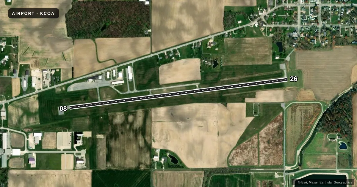
Airport sketch
Runways drawn to scale from FAA survey coordinates, rendered over satellite imagery. Not for navigation.
Approaches & charts
Services on the field
Fuel grades, oxygen, maintenance, ramp storage and lighting — as declared to the FAA by the airport operator.
Fuel & services
- Fuel
- 100LLA
- Oxygen (bottled)
- Not available
- Oxygen (bulk)
- Not available
- Airframe repair
- Not available
- Power plant repair
- Not available
Ramp & ground
- Transient storage
- Tie-down
- Hangar
- Landing fee
- No fee published
- Customs
- Not available
- Lighting schedule
- SEE RMK
- Beacon schedule
- SS-SR
- Beacon
- White / Green (civil land)(WG)
- Wind indicator
- Yes
- Segmented circle
- No
Fuel & FBOs
Cheapest 100LL and Jet A on the field and nearby. Always confirm with the FBO before taxi.
Airport notes
Surface conditions, obstructions, local procedures, lighting outages and other notes published with each FAA cycle.
General notes
- FOR CD CTC COLUMBUS APCH AT 614-338-8537.
- BIRDS & WILDLIFE ON & INVOF ARPT.
Lighting notes
- ACTVT REIL RWY 08 & 26; MIRL RWY 08/26 - 123.3.
Fuel notes
- 100LL100LL & JET A AVBL H24 SELF SVC VIA CREDIT CARD.
Approach & departure obstructions
- 2610-12 FT BRUSH, 75 FT DIST, 175 FT R.
Other notes
- MANAGERLAKEFIELD.CQA@GMAIL.COM.
- MANAGEROR 419-268-2190.
VFR map & nearby airports
VFR sectional. Tap any ICAO chip to open that airport.
Key facts · KCQA
Answer card- ICAO
- KCQA
- Name
- LAKEFIELD
- Location
- CELINA, OHIO
- Elevation
- 894.3 ft MSL
- Traffic pattern altitude
- 1,894.3 ft MSL (1,000 AGL)
- Control tower
- Non-towered (use CTAF)
- Total runways
- 1
- Longest runway
- 08/26 · 4,400 ft
- Published ILS approaches
- 0
- Published frequencies
- 4
- Magnetic variation
- 4°
- Current flight rules
- VFR
- Current wind
- 000° at 0 kt
- Favored runway now
- –
Lakefield is in Celina, Ohio. Field elevation is 894.3 ft MSL. The airport has one runway, 08/26, at 4,400 ft asphalt. It is an untowered field. CTAF and UNICOM are both 122.8. Columbus Approach handles the area on 134.45 and 352.05. No ILS approaches are published here.
Pattern altitude is not published. Use 1,000 ft AGL for light piston traffic unless local guidance says otherwise. The field has 100LL and Jet A available on the field at Lakefield Airport. Fuel is self-serve 24 hours a day by credit card. Runway end identifier lights are available for 08 and 26. Medium intensity runway lights are available on 123.3.
A first-time pilot should plan for wildlife on and near the airport. There is also brush near runway 26. It sits about 75 ft from the runway and about 175 ft right of centerline. For clearance delivery, contact Columbus Approach at 614-338-8537. If you need current operational details, check the current FAA Chart Supplement or call the airport operator directly. The airport manager can be reached at lakefield.cqa@gmail.com or 419-268-2190.