METAR & TAF KAXV
Current METAR
Observed 16:35Z
KAXV 271635Z AUTO 22005KT 10SM SCT010 SCT050 SCT070 25/23 A2991 RMK AO2
- Wind
- 220° @ 5 kt
- Visibility
- 10 SM
- Temp / Dew
- 25°C / 23°C
- Altimeter
- 29.91 inHg
- Clouds
- SCT
- Density alt
- 2,344 ft
- Ceiling
- Unlimited
- Rules
- VFR
Airport info & contacts
Manager on record, flight service, ARTCC, attendance schedule and pattern altitude — published by the FAA and refreshed every 28 days.
Location
- From city
- 8 NM SW
- VFR sectional
- DETROIT
- Pattern altitude
- 990 ft AGL · 1,902 ft MSL
- ARTCC
- ZID · INDIANAPOLIS
- NOTAM facility
- AXV (NOTAM-D)
Airport manager
- Name
- TED BERGSTROM
- Phone
- 419-753-2810
- Address
- PO BOX 400, NEW KNOXVILLE OH 45871-0400
Flight service · Hours
- FSS DAY
- DAYTON1-800-WX-BRIEF
- Attendance
- MON-FRI · 0700-1700
- SAT-SUN · ON CALL
Frequencies
Tap any row to copy the frequency to your clipboard.
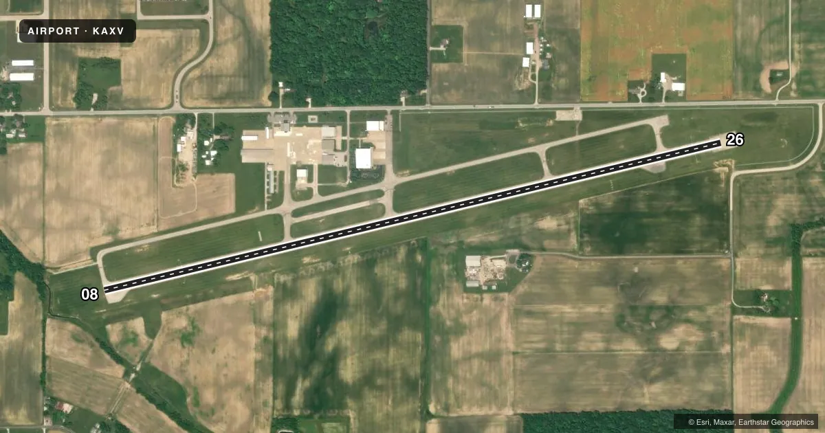
Runways & pattern
Full pagePattern entry · RWY 26
LEFT TRAFFICRunway end performance
| End | TORA | TODA | ASDA | LDA | VGSI | Approach lights | Obstruction |
|---|---|---|---|---|---|---|---|
| 08 | — | — | — | — | PAPI 4-box left(4°) | — | 89', trees, 485' from thr, 238' R of cntrln, slope 3 |
| 26 | — | — | — | — | PAPI 4-box left(3°) | — | 15', road, 330' from thr, 275' R of cntrln, slope 8 |
Declared distances in feet. TORA = takeoff run available, TODA = takeoff distance, ASDA = accelerate-stop, LDA = landing distance.
Airport sketch
Runways drawn to scale from FAA survey coordinates, rendered over satellite imagery. Not for navigation.
Approaches & charts
Services on the field
Fuel grades, oxygen, maintenance, ramp storage and lighting — as declared to the FAA by the airport operator.
Fuel & services
- Fuel
- 100LLA1+
- Oxygen (bottled)
- High pressure
- Oxygen (bulk)
- Not available
- Airframe repair
- Major
- Power plant repair
- Major
- Other services
- INSTR
Ramp & ground
- Transient storage
- Tie-down
- Landing fee
- No fee published
- Customs
- Not available
- Lighting schedule
- SEE RMK
- Beacon schedule
- SS-SR
- Beacon
- White / Green (civil land)(WG)
- Wind indicator
- Lighted
- Segmented circle
- No
Fuel & FBOs
Cheapest 100LL and Jet A on the field and nearby. Always confirm with the FBO before taxi.
Airport notes
Surface conditions, obstructions, local procedures, lighting outages and other notes published with each FAA cycle.
General notes
- FOR CD CTC COLUMBUS APCH AT 614-338-8537.
- WILDLIFE ON & INVOF ARPT.
Lighting notes
- ACTVT REIL RWY 08 & 26; MIRL RWY 08/26 - 122.7.
Fuel notes
- 100LL100LL & JET A1+ AVBL H24 SELF SVC VIA CREDIT CARD.
Approach & departure obstructions
- 268 FT FENCE, 65-200 FT DIST, 220-230 FT L.
- 08APCH SLP 13:1 TO DTHR DUE TO +89 FT TREE, 1168 FT DIST, 238 FT L.
- 26APCH SLP 20:1 TO DTHR
Other notes
- 2FOR SVC & FUEL CALL AMGR.
VFR map & nearby airports
VFR sectional. Tap any ICAO chip to open that airport.
Key facts · KAXV
Answer card- ICAO
- KAXV
- Name
- NEIL ARMSTRONG
- Location
- WAPAKONETA, OHIO
- Elevation
- 912.3 ft MSL
- Traffic pattern altitude
- 1,902.3 ft MSL (990 AGL)
- Control tower
- Non-towered (use CTAF)
- Total runways
- 1
- Longest runway
- 08/26 · 5,500 ft
- Published ILS approaches
- 0
- Published frequencies
- 4
- Magnetic variation
- 4°
- Current flight rules
- VFR
- Current wind
- 220° at 5 kt
- Favored runway now
- RWY 26
NEIL ARMSTRONG is in Wapakoneta, Ohio. The field elevation is 912.3 ft MSL. It has one runway. Runway 08/26 is 5,500 ft of asphalt. The airport is not towered. CTAF and UNICOM are both 122.8. Pattern altitude is 990 ft AGL, which is 1,902.3 ft MSL.
There are no published ILS approaches here. The on-field FBO is Auglaize County Airport Authority. It carries 100LL, Jet A and Jet A Prist. Published remarks say 100LL and Jet A1+ are available 24 hours self-serve by credit card. That is useful if you are planning an early arrival or a late departure. Wildlife is reported on and near the airport. Keep a sharp scan on taxi, takeoff and landing.
Runway lighting is available on 08 and 26. Runway end identifier lights are also active. For clearance delivery, contact Columbus Approach at 614-338-8537. Published remarks also note obstructions near both ends. Runway 26 has a displaced-threshold approach slope note tied to an 8 ft fence near the left side. Runway 08 has a steeper approach slope note tied to a tree left of centerline. If you are new to the field, plan for a careful stabilized approach. Verify current details in the FAA Chart Supplement before you go.