METAR & TAF KVNW
Current METAR
Observed 13:35Z
KVNW 271335Z AUTO 23005KT 10SM CLR 24/24 A2993 RMK AO2
- Wind
- 230° @ 5 kt
- Visibility
- 10 SM
- Temp / Dew
- 24°C / 24°C
- Altimeter
- 29.93 inHg
- Clouds
- CLR
- Density alt
- 2,043 ft
- Ceiling
- Unlimited
- Rules
- VFR
Airport info & contacts
Manager on record, flight service, ARTCC, attendance schedule and pattern altitude — published by the FAA and refreshed every 28 days.
Location
- From city
- 1 NM WSW
- VFR sectional
- DETROIT
- Pattern altitude
- 812 ft AGL · 1,599 ft MSL
- ARTCC
- ZAU · CHICAGO
- NOTAM facility
- VNW (NOTAM-D)
Airport manager
- Name
- JAMES BLACK
- Phone
- 419-232-4500
- Address
- 901 ELKS DR, VAN WERT OH 45891-8202
Flight service · Hours
- FSS DAY
- DAYTON1-800-WX-BRIEF
- Attendance
- MON-FRI · 0730-1600
- SAT-SUN · BY PRIOR ARNGMT
Frequencies
Tap any row to copy the frequency to your clipboard.
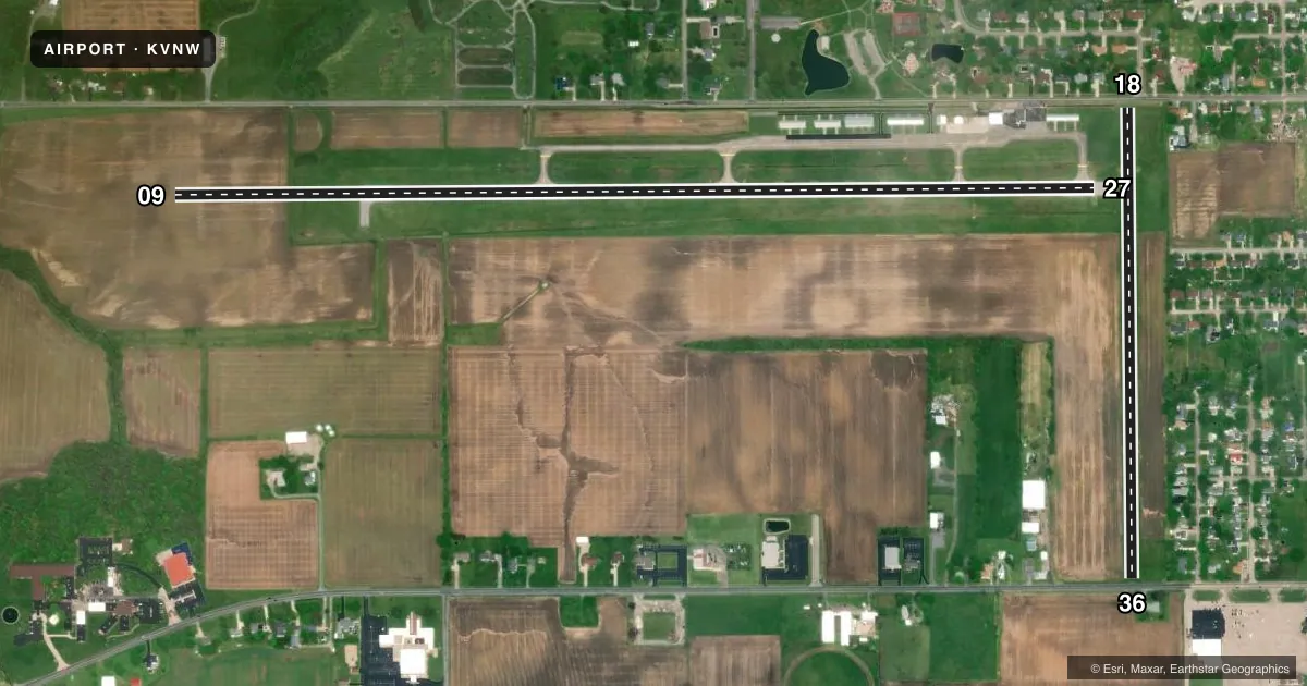
Runways & pattern
Full pagePattern entry · RWY 27
LEFT TRAFFIC| Runway | Heading (°M) | Length | Surface | Traffic |
|---|---|---|---|---|
| 09/27Favored | 85° / 265° | 5,005 ft | ASPH | Standard L |
| 18/36 | 174° / 354° | 2,558 ft | TURF | Standard L |
Runway end performance
| End | TORA | TODA | ASDA | LDA | VGSI | Approach lights | Obstruction |
|---|---|---|---|---|---|---|---|
| 09 | — | — | — | — | PAPI 4-box left(3°) | — | — |
| 27 | — | — | — | — | PAPI 4-box left(3.5°) | — | 3', crops, 201' from thr, 245' R of cntrln, slope 0 |
| 18 | — | — | — | — | — | — | 60', tree, 220' from thr, 45' R of cntrln, slope 3 |
| 36 | — | — | — | — | — | — | 15', road, 20' from thr, 125' R of cntrln, slope 1 |
Declared distances in feet. TORA = takeoff run available, TODA = takeoff distance, ASDA = accelerate-stop, LDA = landing distance.
Airport sketch
Runways drawn to scale from FAA survey coordinates, rendered over satellite imagery. Not for navigation.
Approaches & charts
Services on the field
Fuel grades, oxygen, maintenance, ramp storage and lighting — as declared to the FAA by the airport operator.
Fuel & services
- Fuel
- 100LLA+
- Oxygen (bottled)
- Not available
- Oxygen (bulk)
- Not available
- Airframe repair
- Minor
- Power plant repair
- Minor
- Other services
- INSTR,RNTL
Ramp & ground
- Transient storage
- Tie-down
- Landing fee
- No fee published
- Customs
- Not available
- Lighting schedule
- SEE RMK
- Beacon schedule
- SS-SR
- Beacon
- White / Green (civil land)(WG)
- Wind indicator
- Lighted
- Segmented circle
- No
Fuel & FBOs
Cheapest 100LL and Jet A on the field and nearby. Always confirm with the FBO before taxi.
Airport notes
Surface conditions, obstructions, local procedures, lighting outages and other notes published with each FAA cycle.
General notes
- FOR CD CTC CHICAGO ARTCC AT 630-906-8921.
- ULTRALIGHTS OPR EVES, WKENDS, & IN NO-WIND CONDS.
Lighting notes
- ACTVT REIL RWY 09 & 27; PAPI RWY 09 & 27; MIRL RWY 09/27 - CTAF. TWY LGTS AT ENTRANCE TO RWY 09/27.
Approach & departure obstructions
- 27OBSTN CLNC SLP 0:1 TO THR OVR +3 FT CROPS, 0-200 FT DIST, 245 FT L.
- 18DTHR MKD.
- 36DTHR MKD.
- 18OBSTN CLNC SLP 8:1 TO DTHR OVR +60 FT TREE, 521 FT DIST, 45 FT L.
- 27OBSTN CLNC SLP 0:1 TO THR OVR + 3FT CROPS, 201 FT DIST, 245 FT L.
- 36OBST CLNC SLP 0:1 TO DTHR DUE TO +3 FT CROPS, 40 FT L/R.
- 18ALSO ROAD, TREES, & BLDGS.
- 36ALSO ROADS, TREES, & BLDGS.
VFR map & nearby airports
VFR sectional. Tap any ICAO chip to open that airport.
Key facts · KVNW
Answer card- ICAO
- KVNW
- Name
- VAN WERT COUNTY
- Location
- VAN WERT, OHIO
- Elevation
- 786.9 ft MSL
- Traffic pattern altitude
- 1,598.9 ft MSL (812 AGL)
- Control tower
- Non-towered (use CTAF)
- Total runways
- 2
- Longest runway
- 09/27 · 5,005 ft
- Published ILS approaches
- 0
- Published frequencies
- 7
- Magnetic variation
- 5°
- Current flight rules
- VFR
- Current wind
- 230° at 5 kt
- Favored runway now
- RWY 27
Van Wert County Airport sits in Van Wert, Ohio. Field elevation is 786.9 ft MSL. The airport has two runways. The longest is 09/27 at 5,005 ft on asphalt. Runway 18/36 is 2,558 ft on turf. There is no control tower. Pattern altitude is 812 ft AGL, which is 1,598.9 ft MSL.
No ILS approaches are published here. For IFR work, plan with the current Chart Supplement and the Fort Wayne approach frequencies in hand. The on-field FBO is Van Wert County Airport. It carries 100LL and Jet A with Prist. Call (419) 232-4500 for current service details before arrival.
Runway lighting is pilot-controlled on 09/27. REIL and PAPI are published for 09 and 27. Taxiway lights are at the entrance to runway 09/27. The remarks also call out displaced thresholds on 18 and 36. They also note obstacle issues near those ends. Runway 18 has trees, roads and buildings nearby. Runway 27 has crops close to the approach path. Ultralights operate evenings, weekends and in no-wind conditions. If you are new to the field, brief the runway 09/27 lighting, the displaced thresholds and the surrounding obstacles before you go.