METAR & TAF KDFI
Current METAR
Observed 09:53Z
KDFI 270953Z AUTO 00000KT 6SM BR CLR 19/18 A2989 RMK AO2 SLP115 T01890183
- Wind
- 000° @ 0 kt
- Visibility
- 6 SM
- Temp / Dew
- 19°C / 18°C
- Altimeter
- 29.89 inHg
- Clouds
- CLR
- Density alt
- 1,394 ft
- Ceiling
- Unlimited
- Rules
- VFR
Airport info & contacts
Manager on record, flight service, ARTCC, attendance schedule and pattern altitude — published by the FAA and refreshed every 28 days.
Location
- From city
- 4 NM NW
- VFR sectional
- DETROIT
- ARTCC
- ZOB · CLEVELAND
- NOTAM facility
- DFI (NOTAM-D)
Airport manager
- Name
- TONY SAXTON
- Phone
- 419-658-4444
- Address
- 20399 AIRPORT RD, DEFIANCE OH 43512-6763
Flight service · Hours
- FSS CLE
- CLEVELAND1-800-WX-BRIEF
- Attendance
- MON-FRI · 0800-1800
- SAT · 0800-1200
Frequencies
Tap any row to copy the frequency to your clipboard.
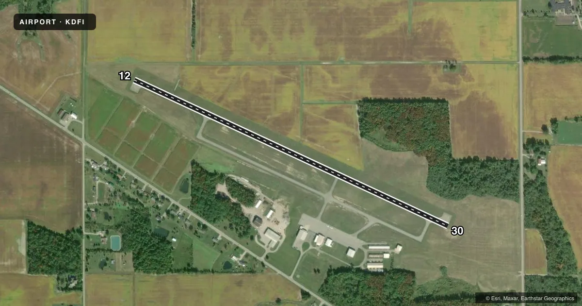
Runways & pattern
Full pagePattern entry · RWY 12
LEFT TRAFFICRunway end performance
| End | TORA | TODA | ASDA | LDA | VGSI | Approach lights | Obstruction |
|---|---|---|---|---|---|---|---|
| 12 | — | — | — | — | PAPI 4-box left(3°) | — | 60', trees, 1445' from thr, 103' R of cntrln, slope 20 |
| 30 | — | — | — | — | PSIL | — | 75', trees, 1385' from thr, 252' R of cntrln, slope 15 |
Declared distances in feet. TORA = takeoff run available, TODA = takeoff distance, ASDA = accelerate-stop, LDA = landing distance.
Airport sketch
Runways drawn to scale from FAA survey coordinates, rendered over satellite imagery. Not for navigation.
Approaches & charts
Services on the field
Fuel grades, oxygen, maintenance, ramp storage and lighting — as declared to the FAA by the airport operator.
Fuel & services
- Fuel
- 100LLA+
- Oxygen (bottled)
- Low pressure
- Oxygen (bulk)
- Not available
- Airframe repair
- Major
- Power plant repair
- Major
- Other services
- INSTR,RNTL
Ramp & ground
- Transient storage
- Tie-down
- Hangar
- Landing fee
- No fee published
- Customs
- Not available
- Lighting schedule
- SEE RMK
- Beacon schedule
- SS-SR
- Beacon
- White / Green (civil land)(WG)
- Wind indicator
- Lighted
- Segmented circle
- No
Fuel & FBOs
Cheapest 100LL and Jet A on the field and nearby. Always confirm with the FBO before taxi.
Airport notes
Surface conditions, obstructions, local procedures, lighting outages and other notes published with each FAA cycle.
General notes
- DEER, BIRDS, & WILDLIFE ON & INVOF ARPT.
- FOR CD CTC TOLEDO APCH AT 419-865-1495.
- FOR AFT HRS ACES TO LOBBY SEE SIGN ON TRML DOOR.
Lighting notes
- ACTVT OR INCR INTST REIL RWY 12 & 30; PAPI RWY 12; MIRL RWY 12/30 - CTAF. MIRL RWY 12/30 PRESET LOW INTST.
Fuel notes
- 100LL100LL & JET A+ AVBL H24 SELF SVC VIA CREDIT CARD.
Other notes
- ESTABD BFR 1959.
- PRIOR CDN RQRD FOR HNGR.
- ROPES NOT PRVDD.
- MANAGERTONY@TAS-AVIATION.COM.
VFR map & nearby airports
VFR sectional. Tap any ICAO chip to open that airport.
Key facts · KDFI
Answer card- ICAO
- KDFI
- Name
- DEFIANCE MEML
- Location
- DEFIANCE, OHIO
- Elevation
- 706.9 ft MSL
- Traffic pattern altitude
- 1,706.9 ft MSL (1,000 AGL)
- Control tower
- Non-towered (use CTAF)
- Total runways
- 1
- Longest runway
- 12/30 · 4,199 ft
- Published ILS approaches
- 0
- Published frequencies
- 4
- Magnetic variation
- 5°
- Current flight rules
- VFR
- Current wind
- 000° at 0 kt
- Favored runway now
- –
Defiance Meml sits in Defiance, Ohio. Field elevation is 706.9 ft MSL. The airport has one runway. Runway 12/30 is 4,199 ft asphalt, with magnetic headings of 115° and 295°. There is no control tower. Check current procedures before arrival if you need ATC support. No ILS approaches are published here.
Pattern altitude is not published. Use 1,000 ft AGL for light piston operations unless the current Chart Supplement says otherwise. The field is served by TAS Aviation on the field. TAS carries 100LL and Jet A+ fuel. Self-serve fuel is available 24 hours a day by credit card. Prior coordination is required for hangar. Ropes are not provided.
Runway lighting and PAPI on runway 12 are activated on CTAF. The medium intensity runway lights on 12 and 30 are preset to low intensity. Deer, birds and other wildlife are reported on and near the airport. That matters here, especially for night or low-level traffic. For clearance delivery, contact Toledo Approach. If you need after-hours lobby access, check the sign on the terminal door. This is a small non-towered field with one runway. Keep your scan tight. Verify the latest Chart Supplement before you go.